An Archaeological Evaluation of Site CG19 (44JC659) at Carter's Grove Plantation, Williamsburg, Virginia
Colonial Williamsburg Foundation Library Research Report Series - 1673
Colonial Williamsburg Foundation Library
Williamsburg, Virginia
2009
An Archaeological Evaluation of Site CG19 (44JC659) at Carter's Grove Plantation, Williamsburg, Virginia
Principal Investigator
Marley R. Brown III
Colonial Williamsburg Foundation
Department of Archaeological Research
January 1996
Re-issued
April 2001
Table of Contents
| Page | |
| List of Figures | iii |
| Chapter 1. Introduction and Setting | 1 |
| Chapter 2. Methods | 5 |
| Chapter 3. Prehistoric Overview | 7 |
| Chapter 4. Results | 11 |
| Chapter 5. Interpretation and Recommendations | 27 |
| References Cited | 31 |
| Appendix 1. Oyster Shell Analysis by J. Michael Bradshaw | 33 |
| Appendix 2. Artifact Inventory | 77 |
List of Figures
| Page | |
| 1. Project area location | 2 |
| 2. Location of Site CG19, Carter's Grove Plantation | 3 |
| 3. 1991 and 1992 shovel test locations, Site CG19 | 11 |
| 4. Typical soil profile (Shovel Test 375N 500E) | 12 |
| 5. Potts point (Shovel Test 395N 500E) | 13 |
| 6. Surfer map showing artifact concentrations at CG19 based on combined results of 1991 and 1992 shovel tests | 14 |
| 7. Location of excavation units, Site CG 19 | 15 |
| 8. Feature 2 (Context 606), Test Unit 1 | 16 |
| 9. Test Unit 2, shell deposits and midden | 18 |
| 10. Potts point Test Unit 3 | 19 |
| 11. Plan view, Test Unit 4 | 20 |
| 12. Midden profile, Test Unit 4 | 21 |
| 13. Lithic tools, Test Unit 5 | 22 |
Chapter 1.
Introduction and Setting
Site CG19 is a prehistoric archaeological site located on the Locust Grove Tract of Carter's Grove Plantation, near Williamsburg, Virginia (Figure 1). Between April and July 1992, the Colonial Williamsburg Foundation's Department of Archaeological Research (DAR) conducted test excavations on the site. Site CG19 was discovered and its location recorded in 1978 by Ivor Noël Hume, then Resident Archaeologist for the Colonial Williamsburg Foundation. In 1991 the Department of Archaeological Research, under the direction of Marley R. Brown III, undertook a comprehensive archaeological survey of the Locust Grove Tract (Moodey 1992). At that time CG19 was revisited and surveyed in order to establish the period and nature of the occupation there. That work indicated that the site dated from the Woodland period and that it was a small camp either occupied repeatedly, or occupied for an extended period of time (Moodey 1992:74). Intact features included two oyster shell deposits or middens, and a hearth feature. The site was recommended for further testing, and in the summer of 1992, the DAR went back to Site CG19. This report presents the results of that investigation.
The testing project was carried out under the general direction of Marley R. Brown III, Director of the Department of Archaeological Research, and Staff Archaeologist David Muraca. Project Archaeologist John Metz supervised the field effort. Staff members Cara Harbecke, Gunnar Brockett, Martha Moore and Audrey Horning-Kossler assisted in the field. Recovered artifacts were washed, numbered, and coded by Pegeen McLaughlin-Pullens, who identified the lithic material from the site. Audrey Horning-Kossler identified the prehistoric pottery and Michael Bradshaw analyzed the oyster shells (see Appendix A). Kimberly Wagner provided the maps for this report and rendered all artifact illustrations. Leslie McFaden prepared this report.
Project Area Description and Environmental Setting
CG19 is located approximately eight miles southeast of Williamsburg, on the Locust Grove Tract of Carter's Grove Plantation. Carter's Grove is a 1000-plus acre property sandwiched between the north bank of the James River and Route 60. The focal point of the plantation is the mansion house, built during the 1750s overlooking the James River. Situated on high ground that is separated from the adjoining countryside by ravines and swamps, the property is ideally suited for agricultural activity. The Locust Grove Tract encompasses the western 230 acres of the plantation lands, and it is bounded on the north by Route 60, on the east by Ball Metal plant properties, and on the south by Grice's Run, a small tributary stream that empties into the James River.
Site CG19 is located in the southern part of the Locust Grove Tract, overlooking Grice's Run (Figure 2). It is situated on a level terrace that terminates in a gently sloped finger ridge. The terrace and ridge are flanked on the east and west by ravines that are seasonally wet drainages of Grice's Run; a broad upland field extends to the north. Elevation of the site area is about 25 feet above mean sea level. Traveling southward from the
2
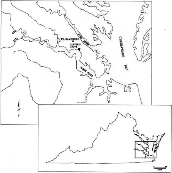 Figure 1. Project area location.
site, one finds wetlands stretching for a distance of about 200 meters (650 feet) from the base of the ridge to Grice's Run, which divides here into an east and west branch. The stream empties into the James River a quarter of a mile further south. Mature stands of mixed loblolly pine, oak, sycamore, spruce, fir, cedar and holly cover the site area, with an understory of honeysuckle, ivies, and greenbriar. A modern logging road cuts through the site, but the terrace has not suffered repeated plowing. The upland field adjacent to the north was once cultivated, but now is planted in loblolly pine for commercial harvest.
Figure 1. Project area location.
site, one finds wetlands stretching for a distance of about 200 meters (650 feet) from the base of the ridge to Grice's Run, which divides here into an east and west branch. The stream empties into the James River a quarter of a mile further south. Mature stands of mixed loblolly pine, oak, sycamore, spruce, fir, cedar and holly cover the site area, with an understory of honeysuckle, ivies, and greenbriar. A modern logging road cuts through the site, but the terrace has not suffered repeated plowing. The upland field adjacent to the north was once cultivated, but now is planted in loblolly pine for commercial harvest.
The project area lies geographically in the Atlantic Coastal Plain. In Virginia, this region is known as the Tidewater, and it extends from the Atlantic coastline into the interior as far west as the Fall Line. The topography is generally flat and ranges from low-lying wet areas to well-drained uplands. There are many tidal creeks and marshes; those along the James River tend to contain brackish or fresh water (Hodges et al. 1985:3). Near major drainages, the land is deeply dissected by steep, seasonally wet ravines. The result is a
3
 Figure 2. Location of Site CG19, Carter's Grove Plantation.
series of small, level terraces that terminate in narrow but fairly level ridges. In prehistoric times, these dissected terraces and ridge tops often provided seasonal camp sites from which to exploit local food resources. The adjacent uplands tend to be ideally suited for agriculture and most have been cultivated during the historic period. The region is an area of moderate climate with mild winters and warm summers; the average winter temperature is 41 degrees Fahrenheit and the average spring/summer temperature is 76 degrees (Hodges et al. 1985:1). Prevailing winds are generally strong (over 15 mph) and originate mostly from the southwest.
Figure 2. Location of Site CG19, Carter's Grove Plantation.
series of small, level terraces that terminate in narrow but fairly level ridges. In prehistoric times, these dissected terraces and ridge tops often provided seasonal camp sites from which to exploit local food resources. The adjacent uplands tend to be ideally suited for agriculture and most have been cultivated during the historic period. The region is an area of moderate climate with mild winters and warm summers; the average winter temperature is 41 degrees Fahrenheit and the average spring/summer temperature is 76 degrees (Hodges et al. 1985:1). Prevailing winds are generally strong (over 15 mph) and originate mostly from the southwest.
Carter's Grove plantation is situated geologically on the Kingsmill scarp, an ancient beachhead that forms a distinct, east-west trending high-ground topographic feature that fronts onto the James River. This high ground gently slopes to an ancient river terrace approximately 30 feet above sea level. Most of the modern river frontage consists of steep, eroded bluffs. Erosion appears to have been a significant process in the development of existing topography, with the slopes of the scarp receiving the greatest impact. The severe storms characteristic of the James River are probably the most significant, natural earth-moving factors.
Soils along CG19's ridge and terrace top belong to the Craven-Uchee complex that is found on slopes of 6-10 percent grade. These soils are moderately well-drained and typically are found on wooded, narrow ridge tops and side slopes. On the site one finds Craven soils, which are characterized by a surface layer of dark grayish brown fine sandy loam about four inches thick, underlain by a pale olive fine sandy loam some five inches thick; the subsoil extends to a depth of about 42 inches and is a yellowish brown clay that becomes a sandy clay loam (Hodges et al. 1985:20-21). While the Craven-Uchee complex is acidic and poorly suited for cultivation, trees such as pine, sweetgum, and oak grow well there. The upland field north of the site is composed of Peawick silt loam, only moderately well suited to cultivation or pasturage but a good soil for loblolly pine (Hodges et al. 1985:33-34). The steep slopes that descend from the ridge top to the marshes of Grice's Run belong to the Emporia complex found on grades of 25-50 percent. These are deep, well-drained soils that are formed over layers of fossil shells (Hodges et al. 1985:26). The marsh itself is composed of Bohicket muck. These tidal marshes have a very high organic content and natural fertility. Besides providing a habitat for a variety of wildlife, the marsh provides nutrients for shellfish (Hodges et al. 1985:16).
Chapter 2.
Methods
The goal of the Department of Archaeological Research (DAR) in undertaking the 1992 excavations at Site CG19 was to assess the site by further defining its boundaries, the density and size of its features, and its overall integrity, or the degree to which the site lay undisturbed and intact. The excavation proceeded in two stages towards this end. First, the crew dug a series of shovel test units designed to complete the grid pattern of tests excavated in 1991. Most of the shovel tests measured 75 × 75 centimeters (cm) across; about a third were 50 × 50 cm units. The tests were placed at ten meter (m) intervals. When full coverage of the site was thus obtained, artifacts recovered from both the 1991 and 1992 excavations were plotted to identify areas of concentration. The second stage of work was based on this spacial analysis. Excavation units measuring two square meters in plan were placed in the areas of artifact concentration determined by the shovel tests, and over the shell middens.
A grid imposed over the site area during the Phase II testing continued to be used for the 1992 excavations. It was aligned with magnetic North and served to divide the site area into measured units for maximum horizontal control. The grid coordinates were tied to a single datum point that was marked with an iron reinforcing bar. Grid coordinate 400N/495E was chosen for the datum.
All test units were excavated by stratigraphic layers using shovels and trowels, and were taken down to sterile subsoil. Each quadrant of the 2 × 2 m units was removed separately, again following natural stratigraphy. Soils were screened through ¼-inch mesh, except where otherwise indicated, and all artifacts were collected. Features were exposed, recorded, and drawn in plan. Each feature then was bisected and one half removed so that a profile drawing could be made, after which the second half was excavated. Physical descriptions of both layers and features were recorded using the DAR's standardized context recording form. Context numbers were assigned sequentially to each unit by layer. All measurements were recorded using the metric system. A sketch map showing terrain, modern disturbances, and unit locations was produced for the site. Photography was used to chronicle the overall testing process, and color slides and black and white photographs were taken of selected units and features.
All finds were washed, sorted, and inventoried using a standard descriptive typology. Artifacts in need of immediate stabilization were sent to Colonial Williamsburg's Department of Conservation. All other material, along with the documentation, was stored at the laboratory and offices of the Department of Archaeological Research.
6Chapter 3.
Prehistoric Overview
Native Americans first occupied eastern Virginia some 12,000 years ago, hunting on and cultivating the land long before the arrival of European settlers. Archaeologists and ethnohistorians traditionally have divided this long history into three, rough chronological periods that mirror changes in material technology. These basic periods—the Paleo-Indian (9500-8000 B.C.), Archaic (8000-1200 B.C.), and Woodland (1200 B.C.-1560 A.D.)—are based on classificatory descriptions of projectile points and ceramic types; the Archaic and Woodland Periods are further broken down into Early, Middle, and Late subdivisions. Recently, researchers that include Gardner (1980) and Custer (1984) have refined this system, offering a behaviorally-based interpretive scheme based on changes in subsistance strategies. Although material culture still provides the means of identifying chronological periods in this new scheme, the focus has shifted to the ways in which native populations adapted to changes in the environment across the millenia. This new scheme is described below in reference to the earlier, or traditional system.
The earliest phase of occupation defined by the new classificatory system (9500-6500 B.C.) includes those periods traditionally referred to as the Paleo-Indian and the Early Archaic. Most archaeologists regard cultural evolution during this period as a direct adaptation to the rigors of Pleistocene and post-Pleistocene environments. Though a variety of food resources were available and used, large game animals provided the main basis for subsistence for a mobile population of hunters. Social groups most likely organized themselves at the band level, an alliance of several family groups that remained flexible enough to adapt to the changes in land and resource availability that were brought on by seasonal cycles and, later, by long-term environmental changes.
These earliest hunters selected high-quality lithic materials from which to produce their tools. Non-local cryptocrystallines, especially jasper and chert, were chosen to make double-sided, multi-purpose implements called bifaces. The sole diagnostic tool type for this period is a finely-crafted, fluted projectile point. These fluted points and bifaces made up a simple, high-quality tool kit that was versatile and easily transported, both important considerations for a semi-nomadic population. The preference for non-local lithic materials may have limited a band's range despite their dependence on game animals. At the same time, the use of high quality, non-local materials promoted long-term curation of those tools. The result archaeologically is that fluted points are quite rare, and sites are correspondingly difficult to find. In most cases, a single fluted point is deemed sufficient to prove Paleo-Indian occupation.
The transition from a colder Pleistocene environment to a slightly more temperate Holocene climate in the latter part of this phase probably reduced the numbers of "megafauna" such as mammoths, forcing greater reliance on elk and deer as the main food source. A shift away from scarce cryptocrystallines to locally-available materials such as quartz and quartzite for tool production also began during the latter part of this phase.
8The settlement patterns of the early hunters remain unclear. This is due primarily to the near absence of available data. No one has yet reported the discovery of an undisturbed early hunter site on the lower James-York peninsula. The few discoveries within other parts of Virginia's Coastal Plain do suggest possibly higher population densities than the data suggests. Robert Hunter has proposed a preliminary model for these early hunter sites. Paleo and early Archaic bands, he has suggested, would have located on "Late Pleistocene-Early Holocene landforms that provided a water source and game attracting capability. Anticipated site types for the area would include small, short duration campsites and possibly kill and butchering sites" (Hunter 1986:39) . Still, the scarcity of research on the nature of paleo-environments makes site prediction difficult at best.
The second chronological period of the new scheme (6500-2000 B.C.) falls entirely within the period commonly referred to as the Middle Archaic. Significant environmental changes occurred over this long time period. Warmer climates, together with an increase in annual rainfall and the growth of deciduous forests, produced an ever greater diversity in both plant and animal communities. This allowed a corresponding shift in the lifeways of aboriginal groups. The estuarine environment probably stabilized during the last part of this phase, ca.3000-2000 B.C.
Important changes in tool production and use occurred during this second phase. The production of tools from locally-available lithic materials such as quartz and quartzite, a trend that had begun late in the first phase, supplanted the earlier reliance on non-local cryptocrystallines. Responding to changes in the variety of food resources, Native Americans also developed an increasingly specialized tool kit that included ground stone tools such as axes, grinding stones, and other plant-processing tools.
Gardner (1980) and Custer (1984) have provided a classification system for sites that date from this period. Permanent sites, whose locations were linked to the availability of food resources and thus to the carrying capacity of the ecosystem, include macroband (large) and microband (small) base camps. Hunting and gathering forays were conducted from transient or procurement sites in order to exploit specific resources.
The third phase in the new scheme (2000 B.C.-1000 A.D.) includes the periods traditionally known as the Late Archaic/Transitional (2000-1200 B.C.), the Early Woodland (1200-500 B.C.), and the Middle Woodland (500 B.C.-1000 A.D.). This grouping, according to Robert Hunter (1986), not only emphasizes cultural continuity, but also affords a more pragmatic solution to the multi-component and non-discrete nature of sites in this area. A large quantity of archaeological and environmental data has allowed archaeologists to study this phase in greater detail than the others. Though much of the environmental data has been extrapolated from other disciplines, it is believed that several important environmental changes—a stabilized sea level, an increase in the salinization of coastal rivers, and an increase in the numbers of anadromous fish and shellfish, particularly oysters—helped initiate the shift to a more sedentary economy, one based increasingly on estuarine and riverine resources. Accordingly, groups established and maintained larger camps for longer periods, and in response to these changing conditions developed new technologies for the acquisition, storage, and preparation of food. Despite this more sedentary lifestyle, however, seasonal forays into the interior zones for game, particularly deer and turkey, and other foodstuffs would have continued.
9The number and variety of diagnostic artifacts increases on sites of this phase. Bowls made of steatite, a non-local material, appeared early but were quickly replaced by a ceramic technology whose range of variability in form, tempering agents, and surface treatments and decorations provides archaeologists with another possible means of classifying cultural change and determining exchange systems. The settlement pattern proposed by Gardner (1980) and Custer (1984) for this phase is similar to that for the previous period. Groups established base camps on "elevated landforms adjacent to a high productivity, riverine or estuarine setting," while procurement sites were likely situated "along interior watercourses in areas varying from small rises along streams to high hilltops" (Hunter 1986:53) .
The final phase of the new scheme corresponds roughly with the period traditionally known as the Late Woodland. It extends from 1000-1560 A.D., the latter date being considered the genesis of contact with Europeans. During this phase, occupation sites became increasingly permanent. European accounts of aboriginal lifeways late in this period indicate that groups had settled more intensively within Inner Coastal areas. The greater diversity of natural resources farther upstream would have supported broader-based consumption. It seems clear also that groups were becoming more reliant on agricultural products like beans, maize, and squash. Thus a desire to locate near agriculturally-productive areas probably would have influenced site location.
Significant changes in the manufacture of ceramics occur during this phase. The use of shell as a tempering agent becomes predominant, and various types of exterior decoration appear more commonly. Style and form in both ceramics and lithics seem to have become increasingly localized. This has made it possible for archaeologists to better identify and understand the movements and distributions of various groups, though it is by no means well-understood. One thing seems clear, however—within the Mid-Atlantic region, the network of exchange and interaction grew in size and intricacy during this period.
10Chapter 4.
Results
Colonial Williamsburg's Department of Archaeological Research (DAR) completed the 1992 testing project at Site CG19 in two stages. The first stage was designed to obtain full coverage of the site area by filling in the pattern of grid-oriented test units begun in 1991 (cf. Moodey 1992). Accordingly, thirty-five shovel test units were excavated at ten meter (m) intervals; forty-five had been dug the previous year (Figure 3). Artifacts recovered from both the 1991 and 1992 excavations were then plotted to identify areas of concentration. Based on those results, a second stage of work was implemented in which larger test units were excavated in the areas of artifact concentration.
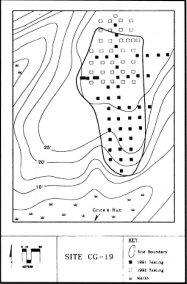 Figure 3. 1991 and 1992 shovel test locations, Site CG19.
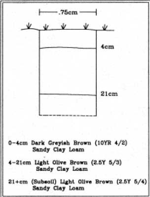 Figure 4. Typical soil profile (Shovel Test 375N 500E).
Stratigraphy
The site is situated atop a small, level terrace that terminates in a gently sloped finger ridge overlooking the marshlands that border Grice's Run. Stratigraphy was fairly uniform across both ridge and terrace (Figure 4). The topsoil averaged ten centimeters (four inches) in depth and was a dark grayish brown (10YR 4/2) sandy clay loam. Topsoil was designated Layer 1. Beneath the topsoil, a layer of light olive brown (2.5Y 5/3) sandy clay loam extended some ten to twelve centimeters. This strata, designated Layer 2, contained prehistoric artifacts. Subsoil that consisted of a light yellowish brown (2.5Y 6/4) sandy clay lay beneath Layer 2. Naturally-occurring ferrous concretions, commonly termed "bog iron" by archaeologists, were found as occasional inclusions in all the soil layers.
Previous Work
Forty-five test units, each measuring 50 × 50 cm, were placed at ten meter intervals across the site area during the 1991 Phase II testing (see Figure 3). This work fully covered the southern half of the site area, which extends from the level terrace onto the slightly sloped ridge overlooking the marsh. Less than half of these units yielded artifacts. Two oyster shell middens were discovered on the northern half of the site. The first had been impacted and exposed by a logging road which cut through the deposit of shells; the second was encountered in a shovel test unit. A stone hearth feature lay at the base of this midden. The conclusions drawn from this work were that prehistoric activity was confined to the northwest quadrant of the site, and to the southern tip, on the ridge top. Lithic 13 debitage, fire-cracked rock, and Middle and Late Woodland ceramic wares were found in both areas. It was recommended that excavation units be dug in the undisturbed midden area in the northwest part of the site and on the ridge top to the south (Moodey 1992:74-75).
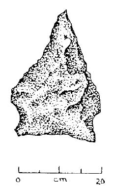 Figure 5. Potts point (Shovel Test 395N 500E).
1992 Field Evaluation
The thirty-five shovel tests excavated during the current project were confined to the northern half of the site, since the southern area had been fully covered the year before (see Figure 3). The tests were dug at ten meter intervals, though they were offset five meters from those of the earlier phase. Twenty-five of the shovel tests measured 75 × 75 cm; ten measured 50 × 50 cm. Seventeen of the total of thirty-five yielded artifacts (see Appendix A). Aborginal pottery recovered from the shovel tests included shell-tempered, Middle Woodland (500 B.C.-900 A.D.) Mockley ware; shell-tempered, Late Woodland (900 A.D.-1560 A.D.) Townsend ware; and sand/grit tempered wares that probably date from the Middle Woodland period. Most of the lithic material was quartzite, with a small percentage of quartz. Flakes and flake fragments, or "shatter," comprised nearly all of the lithic artifacts, though one Middle Woodland, Potts hafted biface was recovered from Shovel Test 395N 500E (Figure 5).
With this stage of the work completed, the combined results of both seasons' testing projects were entered into a Surfer® computer program designed to demonstrate artifact frequency across the site. Borrowing the conventions of a topographic map, Surfer® produces a map using contour-interval lines to signify increasing and decreasing numbers of artifacts. All artifact types from CG19 were entered into the program. The Surfer map revealed five areas of artifact concentration across the site (Figure 6). Four clustered on the northern half of the area that had been tested; the fifth lay on the small finger ridge at the extreme southern end of the area. The first concentration was located just west of the northernmost shell midden, which had been disturbed by the logging road. The second centered over the shell midden that lay along the western edge of the central portion of the site and that was associated with a hearth. Another artifact concentration was located in the center of the site and a fourth lay southwest of that one. The last concentration was located on the ridge in the southernmost area of the site; it was also the least dense in terms of artifact quantity. The concentrations were not purely general in nature, that is, representing a more or less even mixture of artifact types; rather, each signaled a localized concentration of a specific group, such as debitage, pottery, or fire-cracked rock.
Six 2 × 2 meter (m) excavation units were placed in the areas of artifact concentration as defined by the Surfer map (Figure 7). Test Unit 1 centered over a concentration of lithic debitage and was located at grid coordinate 384N 500E (NW), in the center of the site area. Test Unit 2 did not coincide with one of the five concentrations, but was placed over the northernmost shell midden, at grid coordinate 414N/500E (NW). Although the midden appeared on the map, it did not show up as an area of artifact density. Test Unit 3 was
14
 Figure 6. Surfer map showing artifact concentrations at CG19 based on combined results of 1991 and 1992 shovel tests.
15
Figure 6. Surfer map showing artifact concentrations at CG19 based on combined results of 1991 and 1992 shovel tests.
15
 Figure 7. Location of excavation units, Site CG 19.
situated nearby at grid coordinate 417N/493E (NW). It centered over a concentration of prehistoric pottery. Unit 4, at 384N/464.5E (NW), was placed over the western shell midden, which did appear as one of the artifact concentrations on the Surfer map. Unit 5 lay south of there, at coordinate 362N 485E (NW), where a collection of lithic artifacts appeared. Test Unit 6 was located on the ridgetop in the southernmost area of the site, at grid coordinate 324N/495E (NW).
Figure 7. Location of excavation units, Site CG 19.
situated nearby at grid coordinate 417N/493E (NW). It centered over a concentration of prehistoric pottery. Unit 4, at 384N/464.5E (NW), was placed over the western shell midden, which did appear as one of the artifact concentrations on the Surfer map. Unit 5 lay south of there, at coordinate 362N 485E (NW), where a collection of lithic artifacts appeared. Test Unit 6 was located on the ridgetop in the southernmost area of the site, at grid coordinate 324N/495E (NW).
Test Unit 1
Test Unit 1 measured 2 × 2 m in plan and was located in the approximate center of the site area; the northwest corner was placed at grid coordinate 384N 500E. The unit centered over a concentration of lithic debitage, and yielded Middle and Late Woodland (500 B.C.-1560 A.D.) pottery as well. Two features were encountered during the course of excavation; both were in Layer 2. The first was an irregular, bowl-shaped pit located in the northwest quadrant of the test unit against the west wall. After examination, it was determined a tree hole. No artifacts were found in the fill. The second feature, Context 606, was located in the southwest quadrant (Figure 8). Circular (roughly 1 m diameter) in plan and having a shallow (18 cm deep), basin-like profile, Feature 2 contained one fragment of quartzite shatter, two sherds of aboriginal pottery, and numerous bits of burned clay. Layer 2 was subdivided into arbitrary levels for additional vertical control in the northeast and southeast unit quadrants; no further features were encountered, however, and no distinctions were noted between the subdivided strata.
The lithic concentration was light. A few artifacts were recovered from the topsoil layer (Layer 1), but most came from Layer 2. The topsoil yielded two fragments of fire-cracked
 Figure 8. Feature 2 (Context 606), Test Unit 1.
17
rock, two secondary flakes, and one unmodified stone. Layer 2 yielded one fire-cracked rock, four unmodified stones, one primary flake, two secondary flakes, and three flake fragments, or shatter. Cortex was present on the primary flake, and on one secondary flake and one flake fragment (none exhibited more than 74% cortex). All of the flakes and shatter recovered from the unit were quartzite.
Figure 8. Feature 2 (Context 606), Test Unit 1.
17
rock, two secondary flakes, and one unmodified stone. Layer 2 yielded one fire-cracked rock, four unmodified stones, one primary flake, two secondary flakes, and three flake fragments, or shatter. Cortex was present on the primary flake, and on one secondary flake and one flake fragment (none exhibited more than 74% cortex). All of the flakes and shatter recovered from the unit were quartzite.
No ceramic sherds were recovered from the topsoil in Test Unit 1. The sherds found in Feature 2 included one sand-tempered, cordmarked fragment and one unidentified fragment. Layer 2 yielded ten pottery fragments. One was a sherd of shell-tempered, fabric impressed Townsend ware that dated from the Late Woodland period. The remaining sherds dated from the Middle Woodland period; they included one shell-tempered sherd with cord-marked exterior surface treatment, identified as Mockley ware; four other shell-tempered sherds, three sand/grit tempered sherds, and one unidentified sherd. The surface treatment of the latter sherds could not be determined.
Test Unit 2
Test Unit 2 also measured 2 × 2 m, with grid coordinate 414N/500E marking the northwest corner. The unit was centered over the oyster shell midden located in this northern section of the site area. The midden did not coincide with one of the five artifact concentrations defined by the Surfer data, but its location was known due to having been impacted and exposed by a logging road that had previously been cut across the site area. A 50 × 50 cm shovel test excavated in 1991 fell within the northwest quadrant of Test Unit 2, while the logging road obliterated most of the southeast quadrant and a portion of the northeast quadrant. Little remained of Layer 2, as three features cut this layer (Figure 9). Feature 5 (Context 634/635) was shallow (10-20 cm) and amorphous in plan, and consisted of a dark olive brown (2.5Y 3/3) sandy clay loam that contained lithic debitage, Middle Woodland ceramic sherds, and oyster shells. This feature encompassed most of the intact unit area. Features 3 and 4 were two small deposits of oyster shell that lay within Feature 5. Feature 3 (Context 630/631) was encountered in the northwest and southwest quadrants. The oyster shells lay within a matrix of dark brown (10YR 3/3) sandy clay loam that contained several sherds of Middle Woodland pottery and one piece of debitage. The feature was sub-rectangular in plan and 7 cm deep. Feature 4 (Context 632) lay almost entirely within the southeast quadrant. This was the deposit of oyster shell that had been exposed by the road cut. It was comparable to Feature 3 in shape and composition; there were no artifacts. Several smaller pockets of shell also were included within the larger, amorphous feature. This complex of features was interpreted as a refuse midden containing discrete but incidental deposits of discarded oyster shells.
Oyster shells were mixed throughout the soils of the entire test unit. Tools, flakes, and flake fragments all were quartzite. Most of the lithic artifacts were found in the topsoil; they included the tip of a hafted biface, a Stage 1 biface (the least specialized tool type), 38 pieces of shatter, fourteen secondary flakes, and one primary flake. One third of the debitage was cortical (1-74%). A few unmodified stones and fire-cracked rock also were recovered, and one sherd of net-impressed, Mockley ware and one unidentified shell-tempered sherd were found in Layer 1. Feature 5, the large feature that underlay most of the topsoil
18
 Figure 9. Test Unit 2, shell deposits and midden.
in the unit, contained one sherd of Mockley ware, also net-impressed, two sherds of unidentified shell-tempered pottery, three sand/grit tempered sherds, and six pieces of burned clay. Nine fragments of shatter, three secondary flakes, two primary flakes, and a fragment of a Stage 2 biface were recovered from Feature 5, along with two pieces of fire-cracked rock and one unmodified stone. Both primary flakes and one piece of shatter were cortical (1-74%). Feature 3 included one piece of shatter, two fragments of burned clay, three pieces of net-impressed Mockley ware, and one unidentified shell-tempered sherd. Feature 4 contained only shell.
Figure 9. Test Unit 2, shell deposits and midden.
in the unit, contained one sherd of Mockley ware, also net-impressed, two sherds of unidentified shell-tempered pottery, three sand/grit tempered sherds, and six pieces of burned clay. Nine fragments of shatter, three secondary flakes, two primary flakes, and a fragment of a Stage 2 biface were recovered from Feature 5, along with two pieces of fire-cracked rock and one unmodified stone. Both primary flakes and one piece of shatter were cortical (1-74%). Feature 3 included one piece of shatter, two fragments of burned clay, three pieces of net-impressed Mockley ware, and one unidentified shell-tempered sherd. Feature 4 contained only shell.
 Figure 10. Potts point Test Unit 3.
Test Unit 3
Test Unit 3 was placed a few meters west of Test Unit 2, at grid coordinate 417N 493E (NW corner). The data showed this area to be the locus of a concentration of prehistoric pottery (see Figure 6), and excavation of Test Unit 3 verified that fact. Moderate amounts of quartzite debitage, fire-cracked rock, and shell-tempered pottery were recovered from Layer 1, or topsoil. Layer 2, however, included a total of 113 sherds from the four quadrants of the 2 × 2 m unit. A hammerstone fragment and a Middle Woodland (500 B.C.-900 A.D.), Potts projectile point were also recovered from Layer 2, along with lithic debitage and fire-cracked rock (Figure 10). Stratigraphy in Test Unit 3 included a third soil layer beneath Layer 2, sealing subsoil. Layer 3 was a brown (10YR 5/3) sandy clay loam that was 8-10 cm thick. Moderate quantities of lithic debitage and shell-tempered pottery were included in this layer. No features were encountered in Test Unit 3.
Test Unit 4
Test Unit 4 was located at grid coordinate 384N 464.5E (NW corner), near the western edge of the terrace and over the second shell midden. The unit initially measured 2 × 2 m, but it was expanded to ten square meters during the course of excavation to encompass more of the shell midden; ultimately, some three square meters of midden fill were exposed (Figure 11). The shovel test excavated during the 1991 evaluation was incorporated in Test Unit 4. The topsoil, Layer 1, was a very dark grayish brown (10YR 3/2) in this area. This was not surprising given the organic nature of the feature directly beneath. The midden both cut and sealed Layer 2. Only the midden was removed; the soil surrounding and underlying it (Layer 2) was not excavated. Two layers made up the midden fill (Figure 12). The upper layer ranged from a very dark grayish brown (10YR 3/2) sandy clay loam to a dark brown (10YR 3/3) clay loam. It was distinguished from the overlying topsoil by texture, sometimes by color, and by a noticeable increase in artifact and oyster shell content. The lower midden layer was a dark grayish brown (10YR 4/2) sandy clay loam.
In addition to oyster shells, both midden layers contained Mockley and other shell tempered wares, sand/grit tempered pottery, bits of burned clay, quartzite debitage, fire-cracked rock, faunal bones, including a large antler fragment, and charred and uncharred seeds. While shells were present throughout the midden, several dense pockets of oyster shell were discernable in the fill. These discrete deposits were given Feature Numbers 6-10 (see Figure 11). Each feature was visible in the upper midden layer, and all but one extended into the lower midden layer. They were amorphous in plan, and nearly all were shallow (6-10 cm), containing mostly shell. A flotation sample from Feature 6 (Context 669/670) included charred nut fragments.
20 Figure 11. Plan view, Test Unit 4.
Test Unit 5
Test Unit 5 centered over a concentration of lithic material, with its northwest corner at grid coordinate 362N 485E. Excavation of this 2 × 2 m test unit revealed a dense concentration of debitage that included over 1400 quartzite flakes and flake fragments. Twelve tools, including several hafted bifaces, were also recovered from this test unit, along with 32 fragments of unworked stone and one large cobble. Middle Woodland pottery sherds
21
 Figure 12. Midden profile, Test Unit 4.
and one Late Woodland, Townsend sherd were recovered as well. No features were encountered in the test unit.
Figure 12. Midden profile, Test Unit 4.
and one Late Woodland, Townsend sherd were recovered as well. No features were encountered in the test unit.
Test Unit 5 was located on the southern half of the terrace, approaching the sloped ridge; consequently, the topsoil layer was relatively thin: about 5 cm in depth. Both debitage and pottery were found in this layer, along with a hafted biface of quartzite and a bifacial tool of sandstone. The hafted biface was a Middle Woodland, triangular type called Yadkin. Layer 2 was divided into arbitrary levels for maximum vertical control: 5 cm were removed from the upper portion of the stratum and labeled Layer 2a; the rest of the layer extended to sterile subsoil and averaged from 5-8 cm in depth. There were no artifactual distinctions between the levels; artifact counts were slightly greater in the upper level. Debitage from Layer 2a numbered 746, and from Layer 2b, 649. Middle Woodland pottery was recovered from both levels (32 sherds from 2a, and 16 sherds from 2b). Tools included four unidentified hafted biface fragments from level 2b. Level 2a yielded a Potts hafted biface, a Yadkin hafted biface, and four bifacially-worked tools (Figure 13).
Test Unit 6
Test Unit 6 was located at the extreme southern tip of the site, on the gently sloped finger ridge that overlooks the Grice's Run marshland. The lithics here were not as numerous as at other concentrations on the site (at Test Unit 5, for example), but it was a moderately dense assemblage. Following the procedure used in excavating Test Unit 5, Layer 2 was divided into arbitrary, 5 cm levels. In addition, all soils from Layer 2 were screened through 1/8" mesh. Soils from the northwest quadrant of Level 1 also were passed through 1/8" mesh; the remainder of the topsoil was screened through ¼" mesh. Aboriginal pottery and lithic debitage were recovered from all levels. No features were encountered.
22 Figure 13. Lithic tools, Test Unit 5.
Twenty-four fragments of fire-cracked rock were recovered from Layer 2, most of it being found in the northwest quadrant of the unit. The fire-cracked rock was deposited in the upper level of the layer (2a); there was no discernable hearth feature resting on top of subsoil. Two quartzite cores, bifacially reduced, were also recovered from Layer 2a along with a quartz, bipolar flake and one quartzite, primary flake. There was one unmodified cobble beneath the plowzone. Of a total of 35 secondary flakes recovered from Layer 2, all but two were quartzite; 11% retained 1-74% cortex. Over 75% of the aboriginal pottery found in the unit was recovered from beneath the plowzone: 22 of 29 sherds; all but three of those sherds were found in Layer 2a. None of the pottery was unidentifiable, with the exception of two shell-tempered sherds in the plowzone and one fragment of Middle Woodland, Mockley ware in Layer 2a.
Artifact Analyses
After the field work was completed and the artifacts were inventoried, intensive analyses of the oyster shells, prehistoric pottery, and lithic material recovered from the test units were begun. The oyster shell report is presented in its entirety in Appendix A (Bradshaw 1992).
23Oyster Shells. Samples from both middens were examined for the oyster shell analysis. The northern midden exposed in Test Unit 2 provided two samples, one each from the dense deposits of shell found within the larger midden (Context 630/Feature 3 and Context 632/Feature 4). Five samples were taken from the western shell midden exposed in Test Unit 4. Of those five samples, two came from the upper midden layer (Contexts 653 and 695), two from the lower layer (Contexts 673 and 696), and one from a dense pocket of shell within the larger midden (Context 671/Feature 7). The analysis indicated that the majority of oysters grew densely clustered on flats in Grice's Run. Moreover, the shellfish were harvested between late Fall and early Spring; more specifically, between February and early March. All of the oysters had been shucked, meaning that they were opened raw, as opposed to having been steamed or roasted open. There are several methods of shucking, but the breaks on these shells indicate that most were cracked open, probably with a flat, bifacially worked stone tool. The presence of scorched valves in the middens indicate that the shell heaps were burned periodically to reduce stench, not that the oysters had been roasted.
The analysis showed that the middens were deposited over time. The two samples from the lower layer of the western midden were very similar and might have been contemporaneous. The two samples from the upper layer likewise seemed contemporaneous but later in date. A number of those shells had been stabbed, a shucking technique that probably required more refined tools than did cracking, the only shucking method evident in the shells from the bottom layer. Context 653, one of the two samples from the upper midden layer, was probably the latest accumulation since more of its shells were intact, not having been subjected to intense compaction. The shells from the upper layer samples were probably collected nearer the James River shoreline at the mouth of Grice's Run as there was more variety in the basic shape of the shell, a factor influenced by the environment in which the bivalve grows. It is possible that the upper and lower layers of the midden represent two distinct episodes, or years of harvesting. The shells from the northernmost midden also seemed to have been harvested later than the lower shells of the western midden. Stabbing was evident in the samples from the northern midden, and they too had more of a mixture of shell types (Bradshaw 1992). It seems, then, that the westernmost midden was the older of the two, and that it was deposited over at least two occupation episodes. The northern midden appears to postdate the western midden.
Lithic Artifacts. Lithic artifacts included fire-cracked rock, worked tools, and debitage. The debitage was divided into primary reduction flakes; secondary thinning flakes; tertiary retouch flakes; and flake fragments, or shatter. Each flake category was also indentified as to cortical or non-cortical pieces; the former were classed in terms of the relative percentage of cortex present on the flake (1-74 percent, >75 percent). Angular, blocky fragments that probably were by-products of stone working were counted, as were unmodified stones and cobbles. Utilized and retouched flakes were recognized, and formal tools were assigned to stages of reduction, with stage one exhibiting the least amount of flake reduction, and stage four being a finished, hafted biface.
After identifying the lithic artifacts according to the categories described above, the formal and informal tools were evaluated using Peter Pagoulatos' formula for site interpretation. 24 Pagoulatos presented a model of site types based on lithic tool analysis in his article, "Native American Land-Use Patterns of New Jersey: Some Testable Hypotheses" (1992). Using a Coefficient of Variation (CV) to measure site activities as represented by the types and frequencies of formal and informal stone tools, the author defined four different site types. Base I Locations are "characterized by a wide range of artifact types [and features], indicative of manufacturing, maintenance, and procurement activities" (Pagoulatos 1992:62). The largest social population gathered together during the year—the macroband—would inhabit Base I Locations. Base II Locations also are represented by a wide range of artifact types, but densities are moderate and types of features more restricted; Base II Locations describe sites that saw seasonal re-use by microbands of related families. Target I Locations were the focus of more specialized activities such as hunting or nut processing carried out by task groups or families, and would be found close to a specific resource. Target II Locations are characterized by few artifact types and very low artifact density; they represent "brief occupations of a specialized nature" designed to exploit "a single [resource] commodity" by a task group or even an individual (Pagoulatos 1992:62).
Pagoulatos' formula for site interpretation was applied to the lithic material recovered from Site CG19. The CV value calculated for the site, 91.82, indicated that the site was either a Base II or Target I location. Those two locational models describe areas that were seasonally occupied or designed to exploit a specific resource or resources. Pagoulatos predicts features associated with cooking activities, trash disposal, and household areas for Base II; features on Target I locations would be expected to be limited to processing, cooking, and related work areas. Target I locations are further defined as areas where resources are processed prior to transport back to Base I or II locations, with shorter occupation spans than Base II sites.
Site CG19 appears more closely related to Base II locations rather than to Target I camps, despite the fact that it was occupied for the purpose of exploiting a specific, localized resource. Evidence suggests that the site was used repeatedly on a seasonal basis, and that the oysters collected nearby were consumed on-site, not smoked or in other ways processed for later consumption in another, larger camp. Indeed, one possible hearth feature has already been identified on the site, beneath the western shell midden. The middens themselves qualify as trash disposal features. One might expect with further excavation to find additional hearth features as well as features associated with structures, especially patterned postholes.
Aboriginal Pottery. Most of the pottery recovered from the test units dated from the Middle Woodland period (500 B.C.-900 A.D.) and was either shell-tempered or sand tempered. The shell-tempered pottery included sherds of Mockley Ware. It is likely that a large percentage of the remaining shell-tempered sherds were also Mockley, but most were too small or eroded for positive identification. Shell-tempered sherds outnumbered sand tempered ware. Both cordmarked and net impressed surface treatments were noted. A few sherds of a Late Woodland (900 A.D.-1560 A.D.) shell-tempered pottery, Townsend Ware, were also identified. No discernable pattern of distribution could be ascertained at this stage of the site investigation.
Summary
The 1992 archaeological evaluation of site CG19 suggests that this was a seasonal camp occupied during late winter/early spring for the purpose of exploiting local environmental resources, particularly the oyster beds in Grice's Run creek. Secondary activities included tool maintanence and the production of finished tools from rough blanks, often called preforms. Diagnostic artifacts date mostly from the Middle Woodland period (500 B.C.-900 A.D.) and include Potts and Yadkin hafted bifaces and sherds of Mockley ware. A few sherds of Late Woodland (900-1560 A.D.) Townsend ware were also recovered, but the archaeological evidence indicates that the main period of occupation took place during the Middle Woodland period. Analysis of the oyster shells deposited in the middens suggests that the site was revisited over a period of time.
Chapter 5.
Interpretation and Recommendations
The 1992 archaeological investigation of Site CG19 consisted of five test units excavated on the northern half of the site, and a sixth placed 40 m to the south on a small projecting ridge. The test units were laid out according to a pattern of artifact dispersal revealed by earlier shovel testing. The first five incorporated two small oyster shell middens, a concentration of prehistoric pottery sherds, and two lithic concentrations; the last unit also centered over a concentration of lithic debitage. Diagnostic artifacts included stone tools and pottery that date from the Middle Woodland period (500 B.C.-900 A.D.): Potts and Yadkin hafted bifaces and sherds of Mockley ware. A few sherds of Late Woodland (900-1560 A.D.) Townsend ware were also recovered, but the archaeological evidence suggests the main period of occupation took place during the Middle Woodland period.
Few artifacts were found between the northern and southern site areas. The smaller artifact concentration on the south-projecting ridge might represent a camp of short duration unrelated to the occupation on the larger terrace to the north. The lithic artifacts suggest that biface reduction activities took place there, and the reduced numbers of pottery sherds might indicate an earlier date of occupation than that of the northern terrace. An alternate possibility is that the southern concentration simply represents an outlying point of the larger camp. Should that be the case, there might have been structures in the intervening area that yielded so few artifacts between the terrace and ridge. The following discussion is an interpretation of the larger site area as represented by the terrace occupation; it would also pertain to the ridge location if it is associated with the larger area.
The landform that is the location of Site CG19 is protected from the weather conditions of the open river by a series of wooded ridges. Grice's Run, however, provides easy access to the James River. Because the main site area is set back on the terrace, it does not directly overlook Grice's Run and its adjacent marshland, which is a broad expanse also open to weather. The ravine that forms the western perimeter of the site affords an excellant, natural descent to the marsh, where shellfish were gathered. The marsh is also home to muskrat and waterfowl, and various vegetative resources. Deer roamed the woodlands of the upland terrace to the north. The main focus of the site, however, was probably the harvesting of shellfish available in Grice's Run, as indicated by the shell middens revealed in Test Units 2 and 4. Secondary activities included tool maintanence and the production of finished tools from rough blanks, often called preforms. The location of Test Unit 5 was a locus of this activity.
Excavation and analysis of the oyster shell middens on the site suggest that CG19 was a seasonal camp occupied during late winter/early spring for the purpose of exploiting local environmental resources, particularly the oyster beds in Grice's Run creek. Oysters are most nutritionally valuable during this season, which most likely was a lean time for prehistoric peoples. Stores of mast and smoked or dried meat presumably were becoming depleted by late winter, and the growing season for vegetative resources had not yet 28 begun. Analysis of the shells collected from the middens suggests that the site was occupied over a period of time. The western midden predates the northernmost midden; moreover, it was deposited over at least two different occupation episodes.
The oysters of Grice's Run were notably small in size, yet they were harvested anyway. Other oyster shell middens found on Carter's Grove lands are similar to the ones at CG19: all have been comprised of small, relatively inferior specimens. The subtidal streams of the area are low in salinty and therefore marginal enviroments for oyster growth. Severe winters, followed by melting snows that introduced influxes of fresh water caused environmental stress that not only impeded oyster growth, but probably also killed large numbers of the shellfish. The fact that these inferior beds were harvested at all is an indication of the extreme environmental pressures experienced during the time that the site was occupied.
Although the CG19 middens were of moderate size and depth, and represent repeated visits, they are not extensive. The locale might have been visited only in years of extreme scarcity. If a main focus of the encampment was to harvest these inferior oysters, and presumably it was, one might also make a deduction concerning population density and range of Middle Woodland peoples. Extensive oyster beds currently are not found in the James River west of Deep Water Shoals, a situation that probably has changed little since the Middle Woodland period. Native Americans living in the Carter's Grove area did not travel that distance to get those better oysters, but made do with resources closer to home. It is possible that they traded with groups who lived in proximity to heartier oyster populations for smoked or dried oyster meat, but if times were hard, local bands may have been forced to resort to the inferior oysters of nearby subtidal creeks for subsistence. Alternately, such trade networks may not have developed until much later.
Still, it is not a given that CG19 was visited only in years of extreme hardship. Occupation could have been on a semiregular basis, in rotation with locations near other, nearby oyster beds. Site J, also located on Carter's Grove Plantation [distance] west of CG19, yielded similar oyster midden deposits. Most of the pottery found on the site dates from the Middle Woodland period, and annual or at least semiregular occupation might have been the norm during that period. Trade networks with bands living close to heartier oyster populations might not have been developed at that time. Intermittant occupation associated with years of hardship might have occurred during the Late Woodland period. By Late Woodland times, stored cultigens had been added to winter survival strategies, and trade networks may have operated. Both could have seen groups through the winter months in years of plenty, making visits to these sparse oyster beds unnecessary except in years of extreme want.
Recommendations
Further investigation of Site CG19 is likely to yield significant information about this seasonal camp. Additional field excavation is recommended for the area between Test Unit 6 and Test Units 1-5. Artifact density was lowest in this area, suggesting that structures on the site were situated at that location. Several large block excavation units, measuring at least 2 × 2 m each, would be necessary to reveal the patterns of small postholes associated with aboriginal structures. Other features, such as cooking hearths or storage/refuse 29 pits might also be located in this or other areas. Further site examination might also reveal further information about the range of activities pursued at the site, including the subsistance strategies that supplemented this seasonal reliance on oysters. Chemical analysis of feature fill such as middens and hearths would be an important aspect of this investigation. The above excavation strategies, as well as further, in-depth artifact analyses are highly likely to reveal the size of the band or bands that occupied CG19 those many winters ago, thus adding to our slender store of knowledge concerning population density and social structuring during the Middle Woodland period.
References Cited
- 1992
- The Morphological Analysis of the American Oyster Crassostrea virginica(Gmelin): A General Study of Shell Ecofacts from an Archaeological Context. Unpublished manuscript on file, Department of Archaeological Research, Colonial Williamsburg Foundation, Williamsburg, Virginia.
- 1984
- Delaware Prehistoric Archaeology. University of Delaware Press, London.
- 1980
- Subsistance-Settlement Strategies in the Middle and South Atlantic Portion of the United States During the Late Pleistocene and Early Holocene. Paper presented at the 1980 American Anthropology Association Conference, Washington, D.C.
- 1985
- Soil Survey of James City and York Counties and the City of Williamsburg, Virginia. United States Department of Agriculture, Soil Conservation Service and Virginia Polytechnic Institute and State University.
- 1986
- Study Units I, II, III, and IV. In "Towards a Resource Protection Process," Marley R. Brown III and Kathleen J. Bragdon, editors. Unpublished report on file, Department of Archaeological Research, Colonial Williamsburg Foundation, Williamsburg, Virginia.
- 1992
- Phase II Archaeological Investigation of the Locust Grove Tract, Carter's Grove Plantation. Unpublished report on file at the Department of Archaeological Research, Colonial Williamsburg Foundation, Williamsburg, Virginia.
- 1992
- Native American Land-Use Patterns of New Jersey: Some Testable Hypotheses. Journal of Middle Atlantic Archaeology (8): 57-70.
Appendix 1.
Oyster Shell Analysis
Archaeological Project CG-19 (44JC659)
Locust Grove Tract
Carter's Grove Plantation
OYSTER SHELL ANALYSIS
The Morphological Analysis of the American Oyster Crassostrea virginica (Gmelin):
A General Study of Shell Ecofacts from an Archaeological Context
J. Michael Bradshaw
Prepared for
The Colonial Williamsburg Foundation
Department of Archaeological Research
Williamsburg, Virginia
November, 1992
"Let us royster with the oyster - in the shorter days and moister,
That are brought by brown September, with its roguish final R;
For breakfast or for supper, on the under shell or upper,
Of dishes he's the daisy, and of shell-fish he's the star.
We try him as they fry him, and even as they pie him;
We're partial to him luscious in a roast;
We boil and broil him, we vinegar-and-oil him,
And O he is delicious stewed with toast.
We eat him with tomatoes, and the salad with potatoes,
Nor look him o'er with horror when he follows the coldslaw;
And neither does he fret us if he marches after lettuce
And abreast of cayenne pepper when his majesty is raw.
So welcome with September to the knife and glowing ember,
Juicy darling of our dainties, dispossessor of the clam!
To the oyster, then, a hoister, with him a royal royster
We shall whoop it through the land of heathen jam."
The Detroit Free Press
October 12, 1889
Introduction
Along the eastern coast of the United States, oysters are considered one of the most, if not the most significant bivalve. A valuable food source, the oyster has been privately and commercially exploited by humans from prehistoric time to present. The oyster is not only an important food source but a natural resource for building material, agricultural products, and industrial applications (Adams, 1984:29; Alexandrowicz, 1989:1; Bradshaw, 1989:1; Fincham, 1981:2; McHugh and Baily, 1957:43; Sieling, 1950:3; Truitt, 1945:1-3). The aboriginal inhabitants of eastern America used oysters as a dietary supplement and the shells as tools, or for ornamentation, pottery-making, and possibly as a means of barter (Biggs, 1970:423-427; Edwards and Merrill, 1977:32; Truitt, 1945:1-3). The Tidewater area of Virginia allows immediate access to oyster populations by its close proximity to the primary beds and reefs of Chesapeake Bay and its tributaries (Ingersoll, 1881:511; Pearson, 1942:213). Virginia's oyster industries derive mainly from the local waters of the Potomac, Rappahannock, York, James, Nansemond, and Pagen rivers (Richmond, 1930:7).
The availability of oyster meats as a food supplement in Virginia has contributed to successful human habitation through time. Because of its use as a dietary supplement and the subsequent use of discarded oyster valves for lime, roadstone, etc., oyster shells have become important ecofacts in the interpretation of archaeological sites from which they are found (Bradshaw, 1989:1).
Archaeological excavations undertaken on the Locust Grove Tract of Carter's Grove Plantation; specifically site CG-19, revealed extensive data pertaining to occupation(s) spanning the Middle Woodland Period (200-900 A.D.). Material culture associated with various features were recovered, including an assemblage of oyster shell.
Since oyster shells generally retain a record of ecological information, an analysis that contributes to the understanding of human exploitation of oysters is an integral part of interpreting the archaeological record (Kent, n.d.:1). Oyster shell analysis, when used as an interpretive tool in archaeology, is a relatively new specialization. Following the techniques described by Kent (n.d.) as applied by Doms and Custer (1983) and Bradshaw (1989), an attempt has been made to put together a variety of scenarios depicting oyster use through time on site 44JC659.
The scenarios are based on inferences derived from the ecological information of the oyster shells. Consequently, the results of the analyses suggest possible trends and are not definitive conclusions.
Limitations
As in many analytical projects requiring in-depth research and the application of scientific methods, there are limitations to the degree of study. However, in a positive design these methods do provide a basis for future research of the data. Methods of preparation and analyses not undertaken in this study include:
- 1.Preservation of oyster shells: excavated valves are not in equilibrium with their environment once they are removed from a buried context. The shells used in this 36 analysis were cleaned, yet they were not checked for salt recrystallization (Kent, n.d.:16). Additionally, none of the valves were hardened by plastic infiltration or gelatin-formalin infiltration (Kent, n.d.:17) to retard degradation of the more fragile shells. Stabilization of the valves to retard salt recrystallization and/or conchiolin destruction require lengthy and in some cases difficult and dangerous processes. Since the time lapse between excavation and laboratory analysis was minimal, these preservation steps were deemed unnecessary. Also, preserved valves can actually hinder attempts at sclerochronological analyses.
- 2.Estimating human population based on the amount of support from oysters as a food source and/or supplement (Bradshaw, 1990:2).
- 3.Although several analytic methods were not undertaken (i.e. Carbon-14 dating; advanced salinity testing procedures) because of time constraints, standard analyses were performed. For example, microgrowth analysis was attempted using the process of acetate peel preparation, as well as selected analysis of growth check and season of death. Because of poor shell condition and limited expertise in hinge-growth interpretation, there is the possibility of some margin of error in either the tests, results, or both. Therefore, information concerning growth check and season of death should be used as a general guideline with the understanding that other variables could exist that would alter the evidence derived from this analysis.
- 4.Carbon-14 dating and/or growth history determinations based upon stable isotopes, as well as seasonality and mean annual sea surface temperatures from isotopic and sclerochronological records were unnecessary for this project. Also eliminated were salinity tests based on Oxygen-18 to Oxygen-16 and Carbon-13 to Carbon-12 ratios.
Methodologies
Taphonomic Processes
To assess site changes through time and to insure the reliability of data derived from the oyster valve (Kent, n.d.:9), shell conditions were individually noted and then compared with one another. Feature-shell relationships, if any, were examined and the application of historic and oceanographic probability incorporated. Criteria for evaluating the taphonomic processes were limited to two primary destructive mechanisms: physical or mechanical degradation and chemical alteration.
Morphometric Analysis of Shell Shape
Measurement of dorsal-ventral/anterior-posterior dimensions to determine height-length ratios (Gunter, 1938:546-547; Kent, n.d.:28; and Galtsoff, 1964:18-22) provided a means to quantify and statistically analyze shell shape differences per context. Frequency and distribution of lower valves, as well as growth types were examined.
Epibiont Analysis
Many marine organisms attach to and/or bore into oyster shells while the oysters are alive in their natural habitat or the shells are remnants of dead oysters, where the shells serve as a permanent part of the reef or bed substrate. The variety, presence or absence and distribution of these organisms can aid in the interpretation of environmental conditions such as bottom character, water movement, salinity and temperature ranges, food supplies, sedimentation, pollution and disease. In this study the main objective of epibiont identification and analysis is to determine salinity regimes (Galtsoff, 1964:420-430; Kent, n.d.:39).
Harvesting Intensity
An attempt to provide a qualitative estimate of harvesting intensity was made based on shell height and shape similarities. The human factor as well as fluctuations in oyster abundance, distribution and growth rates were considered. Other factors evaluated included differences in harvesting methods (spatial or temporal), proximity and accessibility of oyster flats, and when possible, dietary preference (Kent, n.d.:48-51).
Harvesting Techniques
To understand the technological and cultural patterns used in oyster procurement and preparation for consumption during prehistoric time is difficult since no documentation for harvesting methods and oyster processing exist. However, inferred methods used to collect oysters allows some determination of what habitats could readily be exploited. Coupled with other physical evidence on the shell, seasons of harvest can be suggested. Oyster preparation (shucking and cooking) also lends to the interpretation of seasonality as well as diet, spoilage, etc. (Kent, n.d.:52-59).
Analysis of Shell Microgrowth Patterns
Shell deposition and dissolution is responsible for fine banding or layering generally found in the ligostracum (Carriker, et al, 1980); a thin shell layer covering the valve hinge (Kent, n.d.:52-59). The microgrowth increments are believed to contain an accurate record of freeze-shock, heat-shock, spawning, neap tides, storms and other details of environmental change in the course of a bivalve's existence. Acetate peels of the microgrowth patterns were prepared from a selection of valves that represented a complete HLR range from the sampling of each context.
Distribution Patterns
Comparison of salinity regimes for each context, as well as an overall distribution of saline concentrations was examined. Shells from each context were compared by salinity regime, clustering, physical burning, coloring, and ribbing.
Historical Analysis
Review of records of oystering and oyster use during historic periods was conducted to aid in formulating models and trends of human possiblity for a period of time when written records did not exist. In addition, consultation with marine scientists, biologists, geologists, and archaeologists was used as a means of reconstructing possible environmental conditions back in time.
Analysis
A total sample of 6,207 oyster shells from seven archaeological contexts was collected from the Locust Grove site CG-19 (44JC659). One hundred percent of this assemblage was examined, regardless of shell size, shape or condition.
Four of the contexts from which oyster shells were retrieved were from the main midden area, collected from two arbitrary levels (#653, 673, 695, 696). Context #671 is a feature that cuts the main midden. Contexts 630 and 632 are independant features. Descriptions and locations of these contexts can be found in the site report.
Total Number and Overall Breakdown of Oyster Valves
The overall condition of the shells precludes an exact determination of lower and upper valves. Erosion and solution by ground water has obliterated certain characteristics of many shells in the collection that are used to make these determinations. An estimate, however, has been made. It appears that less than 12% of the assemblage are uppper valves. Both upper and lower valves were subject to analysis even though the lower valve generally yields the most significant ecological information.
In sampling oyster shells from an excavation, valves are catergorized into three groups (Kent, n.d.:19):
- INTACT: This is a valve where both height and length can be measured.
- BROKEN: For this classification, only the height or the length can be measured or neither measurement can be made, yet the valve has a complete hinge.
- FRAGMENT: This is a broken shell that lacks a complete hinge.
Using these catergories, the total quantity obtained from the contexts studied can be grouped as follows:
| Intact | Broken | Fragments |
|---|---|---|
| 1,249 | 1,986 | 2,972 |
Percentages per context are as follows:
| Context # | Intact | Broken | Fragments |
|---|---|---|---|
| 630 | 27.0% | 32.3% | 40.7% |
| 632 | 15.0% | 47.0% | 38.0% |
| 653 | 20.9% | 34.9% | 44.2% |
| 671 | 15.4% | 36.8% | 47.8% |
| 673 | 3.8% | 40.4% | 55.8% |
| 695 | 13.6% | 23.0% | 63.4% |
| 696 | 11.6% | 22.3% | 66.1% |
Oyster Valve Condition
The overall condition of the collected oyster valves is poor, in that 3-27% of the valves in the representative sampling of each context are intact (Figure 1). Broken specimens, which range in quantity between 22-47%, remain analytically useful. Fragments range between 38-66% of the contexts. These fragments were excluded from analysis.
Many factors can account for the degradation of oyster shells on an archaeological site and are generally categorized into two groups: physical and chemical. Most of the damage to the representative sample's microstructures and superstructures appears to be limited to the alteration of mineralization and erosion.
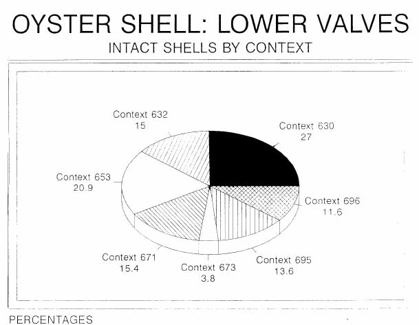 Figure 1.
This limited degradation applies to all specimens in the sampling, whether intact, broken or fragmented. The quantity of broken shells exhibit damage characteristic of:
- 1.Excessive shucking: use of the "cracking" method (Kent, n.d.:55).
- 2.Frost heaving: repeated freezing and thawing while buried in the ground.
- 3.Careless handling at the time of harvest and later when shells were disposed of.
Oysters are commonly categorized by geographic location, particularly in the commercial industries of today. Terms such as "Blue Point," "Cotuit," "Chincoteague," "East Rivers," etc., are examples of marketing classifications. Geographically, the region from which an oyster originates has no bearing on shell shape, although regional variance does appear to affect the interior pigmentation of the valve (Galtsoff, 1964:20). Erosion has destroyed any pigmentation that may have been present in the specimens analyzed. The shell shape variance of the oyster species Crassostrea virginica can be correlated to the environment in which the bivalve lives (Galtsoff, 1964:18).
Kent (n.d.:30) categorizes growth form into four varieties but cautions that habitat can result in some crossover between the groups. The height/length ratio (HLR) of the oyster valves is the primary determining factor for placement within these groups; however, other variables such as ribbing, coloring and extent of clustering are necessary considerations when making these distinctions (Kent, n.d.:28-32).
Of the oyster valves excavated from the contexts represented in the lab sampling, the breakdown of groups in percentages is as follows:
| Context # | Bed | Sand | Channel | Reef |
|---|---|---|---|---|
| 630 | 82.2% | 17.8% | 0.0% | 0.0% |
| 632 | 86.8% | 10.5% | 2.6% | 0.0% |
| 653 | 88.2% | 10.7% | 1.1% | 0.0% |
| 671 | 81.2% | 18.0% | 0.8% | 0.0% |
| 673 | 100% | 0.0% | 0.0% | 0.0% |
| 695 | 84.9% | 9.5% | 5.6% | 0.0% |
| 696 | 100% | 0.0% | 0.0% | 0.0% |
Figure 2 illustrates the extent of valve growth type (in percentages) per context. Bed oysters are the most frequently occurring type followed by sand oysters and channel oysters - in that order. No reef type oysters were present in the assemblages.
Bed oysters generally occur on a mixed muddy sand and can be clustered or individually separated (Kent, n.d.:30). The HLR for bed oysters has been determined to fall between 1.3 and 2.0 cm. Consequently, the mean HLR of oyster valves collected from every context subject to this analysis falls within these parameters (Figure 3). In comparison, the Bassett Hall Woods site, 40BA (BW 40), located near the James River upstream from CG-19, yielded a significant amount of oyster shell, of which the bed oyster was the type most commonly found (Bradshaw, 1990:11).
One determinant of oyster valve growth type is the height/length ratio (HLR) of the shell (Kent, n.d.:30). The mean HLR of the shell ecofacts from the lab samples (See
41
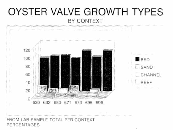 Figure 2.
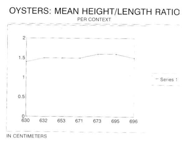 Figure 3.
42
Figure 3), was determined from measurements recorded in Tables I-VII. Each shell, context-by-context, was measured from the dorsal end to the ventral edge to determine height. Length was established from measurements of the anterior-posterior dimension. The individual HLR is derived by using the following equation:
Figure 3.
42
Figure 3), was determined from measurements recorded in Tables I-VII. Each shell, context-by-context, was measured from the dorsal end to the ventral edge to determine height. Length was established from measurements of the anterior-posterior dimension. The individual HLR is derived by using the following equation:
HLR = H/L
(with H being height and L being length)

Ribbing and Coloring
Oyster valves exposed to sunlight characteristically develop "ribs" and undergo color changes depending on the amount of sunlight and duration of exposure. It is generally assumed that intertidal areas yield a greater quantity of sand oysters (and possibly bed oysters), thus, being of a shallow water environment they are much more likely to develop strong radial ribs and exhibit a variety of colorings.
Nevertheless, even oysters which are usually found in deeper water can also display various degrees of ribbing and coloring. Grier (1920:247-285), suggests that color variation can be related to "aging, water acidity and water silt content" (Rhoads and Lutz, 1980:317) , which, coupled with changes in water level, salinity concentrations, bed or reef expansion, etc., could account for this.
The presence or absence of radial, concentric or intersecting ridges on the periostracum of each valve in the sampling was examined and assigned degrees of intensity ranging from slight to moderate, to heavy. Relationships with environmental growth types were calculated context-by-context. The distribution of ribbing for each growth type (by context) is illustrated in Figure 4.
43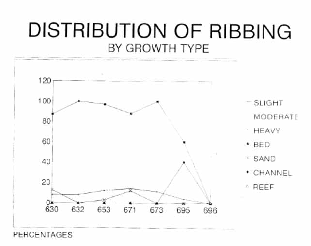 Figure 4.
Bed oysters, the dominant growth type collected (89%), show only a very low percentage of slight ribbing (8.1%). This is unusual in comparison to oyster valves generally associated with historic and prehistoric archaeological sites in the Mid-Atlantic region (Bradshaw, 1989:21; 1990:13; 1990b:12; Egloff, et al, 1988:37; Doms and Custer, 1983:5). The prominent oyster beds located and recorded in historic time (i.e., Hampton Flats, Horsehead Rock, Point of Shoals, Nansemond Ridge, etc.), were subjected to low water levels and tidal shifts. Such action would allow for periodic exposure of the valves to the sun (Bradshaw, 1989:11). Primary oyster beds have been traced into the James River but tend to diminish at Deep Water Shoals near Fort Eustis (Haven and Fritz, 1985:272; Barber, 1992 Personal Communication). Assuming that most, if not all of the oysters harvested by the inhabitants of CG-19 derived from clustered beds in or near Grice's Run; an area that would have had limited tidal shifts, then the existing stressful environment could have prevented the development of periostracal ribbing.1
Galtsoff (1964), notes that rapid sedimentation is quite destructive to an oyster community. Organic or inorganic solids suspended in coastal waters tend to settle to the bottom, depending on environmental conditions and water activity at the time. Water flows 44 can cause both erosion and accretion of sediments. When the direction and speed of tidal currents in an estuary change, the alternating processes of erosion and deposition occur:
"Depending on the configuration of the bottom, certain areas of an estuary are scoured, while vast quantities of sediments are deposited on others. This is typical on oyster grounds in many tidal streams (Galtsoff, 1964:410)."
The Grice's Run area is conducive to such sedimentation, particularly since that area has been significantly affected by tidal currents and changes in sea level through time (Berquist, Personal Communication, 1991). Moving sand or the deposition of mud (Möbius, 1881) or the accumulation of mud, leaves and twigs (Orton, 1937), would prevent exposures to sunlight.
It must be noted that working a shallow bed consistently over time will reduce the bed slope, allowing for a deeper water environment (Mann, personal communication, 1989). Such an environment could possibly yield a lower percentage of ribbed oyster valves.2 In the case of oyster valves collected from CG-19, however, a deeper water environment is unlikely because of the size, condition, and salinity regime depicted by overall shell characteristics.
The affects of coloring in the sampling supports the argument of minimal or no exposure of the valves to the sun or variations in water depth, with little or no tidal fluctuations. The percentage of slight coloring and ribbing is identical in four of the contexts (630, 632, 671, 673). Shells from Context 696 have neither ribbing or coloring. Figure 5 defines the distribution of coloring by growth type. Periostracal color and surface textures are aspects of oyster shell analysis open for continued research into the ecological and evolutionary significance of each (Rhoads and Lutz, 1980:318).
Salinity and Environment
Salinity variability and circulation patterns in typical estuarine environments and between river and sea water is quite complex (Galtsoff, 1964:401). There can be many factors such as size, depth, bottom configuration, flow, etc., affecting salinity patterns and the convergence of water types in any specific estuary (Capper, et al, 1983:137; Galtsoff, 1964:401). Important to oyster survival and subsequently oyster shell analysis is the particular salinity regime in which the bivalve flourished. Reproductive success and continued survival of the oyster appears to be in areas of higher saline concentrations (Capper, et al, 1983:137; Haven and Fritz, 1985:271); however, the bivalve can tolerate a wide range of salinity (Alexandrowicz, 1989:4).
Since pests and parasites of oyster communities also depend on salinity variation Capper, et al (1983:137), Kent (n.d.:39), and Hopkins (1962:121-124) stress the importance of the analysis of such organisms as a salinity determinant. In theory, Kent demonstrates the possibility of salinity estimates by the identification of epibionts attached to the shell and suggests comparisons be made with living bivalves from different regimes as a part of
45
 Figure 5.
the analysis. Such comparisons would probably produce results on a more precise scale; however, access to and the study of living oysters for purposes of this study were not possible. Therefore, the salinity interpretations discussed here are general, yet provide adequate descriptions supported by existing epibionts present or absent on the valve samples.
Figure 5.
the analysis. Such comparisons would probably produce results on a more precise scale; however, access to and the study of living oysters for purposes of this study were not possible. Therefore, the salinity interpretations discussed here are general, yet provide adequate descriptions supported by existing epibionts present or absent on the valve samples.
The epibiont groups currently used as salinity indicators consist of the boring sponges in the genus Cliona, polychaete worms in the genus Polydora, and encrusting ectoprocts such as the bryozoan, boring clam and barnacle (Kent, n.d.:39). Cliona sponges, Polydora worms and boring clams appear to give the best interpretive evidence of salinity regime and oyster relationships. Consequently, only these three groups have been closely examined for this analysis. The presence or absence of bryozoan and barnacles was noted in the analysis.
Salinity levels have been categorized into four regimes appropriately identified as I, II, III, and IV. Regime I is the least saline with the salinity level in the water below ten parts per thousand (ppt) for at least half the year and seldom, if ever, exceeds twenty ppt. This is a stressful environment for most of the parasitic organisms (and oysters as well); therefore, oyster valves of this regime generally exhibit no boreholes (Doms and Custer, 1983:8; Kent, n.d.:41). Boring clams, Diplothyra smithii (Tryon), produce a large cavity within the oyster shell. Their presence would also indicate a fairly low salinity level.
46Regime II represents salinity levels below 10 ppt for at least one-fourth of the year and below 15 ppt for half the year - periodically rising above 20 ppt. Characteristic of shells from this environment would be boreholes with diameters of 0.2-0.5 mm (incurrent) and 0.6-1.6 mm (excurrent). Small borings of this type are usually from the Cliona trutti sponges.
Regime III increases significantly in salinity with the levels sometimes dropping below 15 ppt. However, for at least one-quarter to one-half of the year the salinity rises to over 20 ppt. Both Cliona celata and Cliona trutti sponges are found associated with oysters in this regime, although the boreholes from C. trutti will usually be dominant.
In Regime IV the salinity level rarely drops below 15 ppt and most of the time is well over 20 ppt. The sponge boreholes in this case measure 0.8-2.5 mm (incurrent) and 2.0-4.5 mm (excurrent). Polydora worms generally live in subtidal mud. They are detected by "mud blisters" on the inside of a valve and/or double boreholes around the edge. Boring clams produce a large cavity within the oyster shell. Their presence would indicate a fairly low salinity level.
Overall, salinity regime I is the type of environment from which these oysters were harvested (Figure 6). There were no indications of epibiont destruction characteristic of shells from regimes II, III, or IV. This may be reasoned in several ways. The fact that the
 Figure 6.
47
major tributaries of Chesapeake Bay and the bay itself have a two-layered circulation pattern would be one possibility. In the lower part of the water column can be found a dense, highly saline water type that travels in a net upstream flow. A net seaward flow of fresher, less dense water is found in the upper section (Capper, 1983:137-138). It is possible that the Grice's Run area suffered the influx of seasonal freshets. Freshets, streams of fresh water invading salt water, can occur during or after long periods of rain or as a result of melting snow (Orton, 1937). Möbius (1881) noted that a shallow water environment during a severe winter is quite destructive to oyster beds. Galtsoff (1964) found that "freshets sometimes kill oysters in the James River, Virginia." An influx of fresh water also kills predators.
Figure 6.
47
major tributaries of Chesapeake Bay and the bay itself have a two-layered circulation pattern would be one possibility. In the lower part of the water column can be found a dense, highly saline water type that travels in a net upstream flow. A net seaward flow of fresher, less dense water is found in the upper section (Capper, 1983:137-138). It is possible that the Grice's Run area suffered the influx of seasonal freshets. Freshets, streams of fresh water invading salt water, can occur during or after long periods of rain or as a result of melting snow (Orton, 1937). Möbius (1881) noted that a shallow water environment during a severe winter is quite destructive to oyster beds. Galtsoff (1964) found that "freshets sometimes kill oysters in the James River, Virginia." An influx of fresh water also kills predators.
It is highly probable that salinity levels were reduced dramatically in and around Grice's Run as a result of severe environmental conditions. "Shells of oysters grown under unfavorable conditions are often thin and fragile (Galtsoff, 1964) ." The condition of valves collected from the features of CG-19 may be attributed to this. One hundred percent of the shells analyzed from each context exhibits those characteristics described in Regime I, with either evidence of D. smithii or no trace of epibiont activity whatsoever.
Boring clams are generally found in water with low salinity levels. The relationships in this study between Boring clams, salinity regimes, and environment show the percentage of Boring clams found within a particular valve type from a given salinity level. The following is the distribution by context for these relationships:
| Percentage | Environment | Context | Salinity |
|---|---|---|---|
| <5 | Bed | 630 | I |
| >25 | Bed | 632 | I |
| <10 | Bed | 653 | I |
| <1 | Sand | 653 | I |
| <1 | Channel | 653 | I |
| <10 | Bed | 671 | I |
| >10 | Bed | 673 | I |
| <5 | Bed | 695 | I |
| —— | —— | 696 | I |
Based on the above data, it is assumed that most of the oystering within the periods covered by these contexts was conducted in a subtidal environment somewhere between the shore and river channel or within the cut of Grice's Run.
Season of Death and Growth Checks
An attempt was made to determine the season of death and growth checks through analysis of the shells' hinge area. The growth history of Crassostrea virginica (Gmelin) is preserved in visible morphological characteristics that developed in its shell. Seen as increments and discontinuities of growth, alternating layers of calcium carbonate and organic material produce a physiological pattern of growth history. These micro-bands are produced by the processes of shell deposition and dissolution on the ligostracum (Rhoads and Lutz, 1980).
48Acetate peels were made from a total of 36 shells. The shells were selected from each context on the basis of complete HLR range. Each shell's hinge was washed in water and then allowed to soak for 24 hours in sodium hypochlorite (to dissolve organic matter). Next, shell hinges were again washed in water and then saturated with acetone. Duco cement was applied to the entire hinge area of each shell. Upon drying, shell hinges were heated to release the cement peel. Peels were secured in 2" × 2" coin holders. By magnifying the peels, "relative measurements were made of the amount of hinge growth over the three previous years prior to growth" (Doms and Custer, 1983:6). Using the following formula, these relative measurements were converted to an index of percentage of yearly growth prior to death:
- IG = a/b × 3
- IG = Index of yearly growth
- a = Growth since last winter growth check prior to death
- b = Amount of growth over three years prior to death
The index of growth for each context is as follows:
| 630 | 632 | 653 | 671 | 673 | 695 | 696 |
| .037 | .111 | .104 | .083 | .125 | .128 | .074 |
| .166 | .111 | .066 | .074 | |||
| .083 | .111 | .090 | ||||
| .095 | .125 | .074 | ||||
| .148 | .083 | |||||
| .071 | .185 | |||||
| .111 | .111 | |||||
| .185 | .125 | |||||
| .140 | .074 | |||||
| .133 | .083 | |||||
| .102 | ||||||
| .166 | ||||||
| .055 | ||||||
| .055 | ||||||
| .142 | ||||||
| .083 | ||||||
| .066 |
The mean index of growth for the sample of shells from each context follows:
| .102 | .111 | .109 | .105 | .125 | .092 | .074 |
These figures can be interpreted as the amount of time (or percentage of elapsed year) between the end of the latest winter growth check and the season of death. The IG was then multiplied by 10 (representing the months of the year, excluding January and February when there is no growth):
| 1.02 | 1.11 | 1.09 | 1.05 | 1.25 | .92 | .74 |
If a late December, early January winter growth check is assumed, the season of death depicted by the sample of shells from each context would be as follows: 49
| 630: February | 673: February-Early/Mid March | ||
| 632: February-Early March | 695: Mid-February | ||
| 653: February-Early March | 696: Mid-February | ||
| 671: February-Early March |
The mean IG for the total of all contexts is .105. This would translate into a February-Early March season of death. The age at death for the oysters was determined from a growth ring count. The following is the mean age listing (in years) by context:
| 5.5 | 4.0 | 4.5 | 4.1 | 4.0 | 4.3 | 3.5 |
The shells from CG-19 are very small. Their size is inconsistent with the age at death average (4.3 years). It also indicates that the oysters were living in a very stressful environment.
Preparation of the peels was difficult for various reasons. In most cases, the quality of the shell prevented a readable peel from being produced (115 attempts with no results). Coupled with limited experience in this aspect of oyster shell analysis, the inferences made relative to season of death and age at death should be used only as a guide, since a margin of error in their interpretation may exist.
Valve Clustering
Valve clustering is important in determining habitat of some oysters, particularly those elongated forms with a height-length ratio of more than 2.0 cm. Shells of this type can be found in areas of soft mud or in large dense clusters characteristic of channels and also loosely clustered in shallow water.
Approximately 99.8% of the entire lab sampling show evidence of clustering. Context-by-context, this breaks down as follows:
| Context # | Extent of Clustering |
| 630 | 99.0% |
| 632 | 100.0% |
| 653 | 99.6% |
| 671 | 100.0% |
| 673 | 100.0% |
| 695 | 100.0% |
| 696 | 100.0% |
When clustered oysters were collected, the clusters had to be transported back to land. Since the makeup of clusters includes both live and "dead" shells, these required separation once on shore. It is very likely that the inconvenience of harvesting, transporting and separating clustered oyster types marked these types as the least desireable, yet because of desperation for survival, any inconvenience was tolerated. This also supports the theory that environmental conditions at the time or during a portion of the time CG-19 was inhabited reduced the reliance on hunting and gathering.
Preparation Techniques
The two general methods used for opening oysters depend largely on whether or not there is a preference to having the oyster meats cooked or raw (Kent, n.d.:55). A further breakdown of these two general methods involve the actual techniques used in either category. For instance, to open oysters without cooking them, various shucking techniques are employed individually or in combination with one another:
- 1.Stabbing
- 2.Hammering
- 3.Cracking
To open oysters while preparing a cooked meal at the same time, they can be roasted, steamed or boiled. Although a number of the shells examined were scorched (n=296), and roasting will leave scorch marks (Kent, n.d.:55), it was determined that none of the total valves had actually been prepared in this manner. All of the shells that were partiallly or totally burned were also shucked by either of the previously described mechanical methods. There would be no reason to employ these opening methods on roasted oysters since they would automatically open while cooking.
The cracking method appears to have been the most popular since 81.9% (n=769) of the total analyzed oyster shells were opened this way. Using the cracking method in prehistoric periods probably required a flat, reworked biface since round stones cannot produce the type of breaks noted in this sampling. Stabbing methods (knife, hatchet, etc.) were used on 7.7% (n=72) of the valves. The remaining 10.4% yielded no evidence of shucking. None of the shells showed signs of both stabbing and cracking. The following is a breakdown by context (in percentages) of shucking techniques:
| Context # | Stabbed | Cracked | Both | None |
|---|---|---|---|---|
| 630 | 5.9 | 83.2 | 0.0 | 10.9 |
| 632 | 5.3 | 63.2 | 0.0 | 31.6 |
| 653 | 9.0 | 77.8 | 0.0 | 13.2 |
| 671 | 9.0 | 86.1 | 0.0 | 4.9 |
| 673 | 0.0 | 100.0 | 0.0 | 0.0 |
| 695 | 2.4 | 94.4 | 0.0 | 3.2 |
| 696 | 0.0 | 81.8 | 0.0 | 18.2 |
Results of Analysis
Several trends emerge from the analysis of oyster shell sampled from 44JC659, including methods of preparation for consumption, use of discarded shell, condition of shell, habitat, and method of harvesting.
Careful analysis indicates that the majority of shells were shucked to retrieve the meat of the oyster. The serving of raw oysters is assumed since roasting or steaming does not require the process of shucking.3 Oysters used by the inhabitants of CG-19 were probably 51 collected between late Fall and early Spring. Summertime is the spawning period for oysters and meats are gritty and lack flavor (Jackson, 1988:62). Between August and November, oysters have a higher glycogen level that is stored during the previous summer months. This results in a higher energy-producing food than at any other time (Russell, 1923:9). Another factor that can be attributed to the seasonality of eating oysters is the bivalve's response to salinity levels. The lower the salinity, the more water is absorbed, causing the oyster to swell. In June through October, osmotic pressure causes an increase in salinity and the opposite effect occurs.
In the historic period, oyster shell has proven its worth agriculturally and industrially as a source of lime. Its use in fertilizer and as an agent for acidity reduction of the soil has been widespread (Ingersoll, 1881:563-64). Glassmaking efforts in the 17th and 18th centuries used oyster shell by-products as a flux, where the lime would be mixed with sand, soda ash, and potash (Hudson, 1967:89). Crushed and whole oyster shell has been popular in building construction, roadways, walkways, and drainage systems. Use of oyster shells in prehistoric periods can only be inferred based on some shell-type artifacts and the notion of human posibility. Since empirical evidence for shell use in any manner from the shells of these contexts is nonexistent, the research for this study falls short of delving into this interesting aspect of analysis.
The condition of shells from 44JC659 can be attributed to many factors, mechanical and chemical, through time. Most of the surface and structural degradation appears to be the results of mineralization and erosion. Causal factors for actual breakage can be derived from the excavation itself, reckless shucking techniques, freezing and thawing, careless handling at the time of harvest and handling during subsequent processes. Specifically, though not comprehensive, the following chart illustrates some possibilities for physical and chemical change through time (Bradshaw, 1989:12-15):
| During Growth Periods | During Harvest |
|---|---|
| Epibiont attack | Tonging |
| Effects from transportation | Dredging |
| Harvesting | |
| Tidal changes | |
| Sedimentation | |
| Clustering | |
| Processing | |
| Handling, moving | |
| Shucking | |
| Cooking (roasting, steaming) | |
| Discarding and Shell Deposition | Excavation |
| Erosion | Damage from Tools |
| Freezing and thawing | Packaging |
| Attack from plants and animals | Transportation |
| Human activities | Storage |
| Compaction | Processing |
| During Growth | Processing |
|---|---|
| Exposure to light and heat | Burning |
| Extreme temperature change | |
| Chemical composition of water (leaching) | |
| Discarded Shells | |
| Authigenesis (alteration of mineralization) | |
| Soil composition | |
| Ground water acidity | |
| Permineralization |
In many instances the information stored in the shell during the oyster's life is lost through physical degradation and/or chemical alteration (Kent, n.d.:9-16). Specifically, the physical breakdown of a shell begins the moment it is discarded and continues, depending on the subsequent mechanical activity it is exposed to. Kent (n.d.) cites continued human habitation and related processes such as "tramping, plowing, compaction [as in a midden or trash pit] and excavation" as examples of activities that tend to alter discarded valves without producing any chemical change.
Further physical destruction occurs with the activities of plants, animals, burrowing organisms and insects. Natural processes such as freezing, thawing, drying, wind and water erosion, are all factors that play an important role in the mechanical destruction of discarded oyster valves through time.
Chemical alteration of discarded oyster shells incorporates a complex combination of substance conversions, both organic and inorganic:
- 1.Organic
Mucopolysaccharides, polypeptides and scleroproteins which constitute conchiolin (Kent, n.d.:11). - 2.Inorganic
Mineralogical variation and alteration of calcareous prismatic microstructures. Rhoads and Lutz (1980:100) state that "virtually all mineralogical variations in bivalve shells are associated with at least minor changes in shell architecture or micro-structure."
These conversions occur through dissolution, bacterial decomposition, oxidation, combustion, permineralization, paramorphic substitution, paramorphic transformation and recrystallization (Kent, n.d.:11-16; Rhoads and Lutz, 1980:69-162). An understanding of the chemical modifications of oyster valves is integral to the complete and in-depth shell analysis, as is a complete mineralogical evaluation; however, a full discussion of these processes is beyond the scope of this study.
The reasons why shells may or may not remain intact through generations of time go well beyond those previously cited and are tricky, if not virtually impossible to determine. Since the accumulation of shell in all features of CG-19 were susceptible to the action of ground water and the ground water in and around that particular site is considerably acidic; coupled with the fragility of shells from a stressful environment, it is not unreasonable to 53 infer that the resultant leaching process was the primary cause of chemical alteration and subsequent shell degradation. Additionally, shell middens sometimes have a significant accumulation of human-made debris (broken pottery, lithic debitage and tools, etc., depending on the time period), which could account for some shell breakage during the time of disposal. Also, the overlying weight of additional accumulations could compact the shell midden or shell scatter, creating a degree of stress, thus promoting breakage. The condition of shells from CG-19 suggest that they were not structurally sound enough to withstand a substantial rate of compaction.
An average total of 89% of the valve sampling have been classified as the Bed oyster growth type, commonly found in an environment of mixed sand and mud. A muddy subtidal environment cannot be confirmed, however, since evidence of Polydora worm boreholes and "mud blisters" was nonexistent on the excavated shells. Slightly over 8% of the shells exhibited slight ribbing and coloring with 99.8% scarred from clustering. These factors tend to corroborate the suggestion of a change from the normal subtidal environment.
Only 9.5% (mean) of the total sampling was classified as Sand oysters, 1.4% as the Channel type and 0% as Reef oysters. This indicates that the majority of oysters were neither from the intertidal waters of the shoreline or from very deep waters.
Considering the termination of extensive oyster beds in the James River at or near Deep Water Shoals (a considerable distance from CG-19 on foot), unfavorable environmental conditions as depicted by shell characteristics, the dominance of Bed oyster valves in all archaeological contexts evaluated, and the HLR distribution, it can be argued that the source for most, if not all of the oysters collected by the inhabitants of site 44JC659 during the Middle Woodland Period, was a densely clustered flat - probably existing in the waters of Grice's Run.
Ingersoll (1881:512), noted that Sand oysters were probably the type most frequently acquired and used by Native Americans and colonists of the 17th century. This was because the oysters were plentiful and could be easily collected by hand along the shorelines. It is apparant, then, that at some point between 200-900 A.D., some type of environmental devastation occurred; otherwise, Sand oysters would have probably been preferred and their valves would dominate the midden and associated features.
Hand gathering was probably the only method used to harvest oysters from the Grice's Run flat(s). This method poses little difficulty since estimates show a group of 40-50 individuals can gather by hand approximately 60,000 oysters in 2 hours (Möbius, 1881:739).
Conclusion
Oysters are a highly prized food source whose use has been traced back to the Romans before 78 B.C. Not only did the Romans exploit the natural beds of the Atlantic seacoast, but experimented with the creation of artificial oyster beds, dredging operations and the use of oyster shell in curative powders and cement (Wennersten, 1981:4-5). The English have exploited their local oyster beds for centuries and by the mid-sixteenth century were threatened with the extinction of the valuable bivalve.
54This "king of the seafood industry" (Richmond, 1930:8), has been prevalent along the Atlantic seacoast of the eastern United States since before recorded time (McHugh and Bailey, 1957:42). A valuable source of nutrition from the meat and the useful by-products from the shell have made oysters a natural resource exploited by the American Indians (Hodges, 1988:46), colonists, and generations of people that followed. Little is known or has been recorded about oystering and the use of oysters in Virginia before 1865. Only inferences can be made of the oyster and its interrelationship with humanity prior to New World contact.
Discarded shells showing signs of food preparations by way of shucking marks and scorching from roasting processes are frequently found in prehistoric archaeological contexts as well as shell fragments fashioned into what appears to be ornaments, tools and other implements.
This was the case at site 44JC659 (with the exception of ornamental items or tools), where over 6,000 oyster shells and shell fragments were recovered from seven contexts. Of these shells, it was virtually impossible to calculate the percentage of lower and upper valves. The poor conditions and eroded surfaces obliterated many distinguishing characteristics. Both upper and lower valves are, however, important in shell analysis.
The shell sampling taken from two arbitrary levels of a large midden and three other features were, for the most part, in poor to very poor condition. Post-use shell degradation can be attributed to natural processes such as erosion, exposure to climatic changes, compaction, and leaching of chemicals from the surrounding soils and groundwater. Damage to the shells prior to harvesting was the result of attack by aquatic pests and parasites; specifically, the boring clam D. smithii. The process of harvesting probably also contributed to the overall shell condition. All of the shells were collected by hand (as simple technology like rakes and tongs did not exist). It is, however, virtually impossible to distinguish the origins of shell damage as it relates to harvesting.
The preparation of oysters for consumption damages the valves through opening and cooking procedures. The majority of the shells examined showed signs of shucking, with the cracking method being the most popular. A slightly less popular method, although one that was frequently used, involved stabbing. None of the shells appeared to have been opened by roasting, steaming, or boiling. Although many shells had signs of scorching, it is believed that this was the result of burning the midden periodically to eliminate stench. All or most of the scorched shells had also been shucked. This would not have been necessary if they were roasted since the heat would have opened the valves anyway.
The majority of the oyster valve growth types were Bed oysters, followed by Sand and Channel types, in that order. No Reef oysters could be identified in the assemblage. This would initially indicate that most of the harvesting was from a mixed muddy sand environment, characteristic of local river bottoms. The characteristics of the shells and the information derived from them indicates otherwise. The oysters of CG-19 were probably found clustered in an environment of changing sediments and natural debris. The extent of ribbing and coloring also confirms unfavorable habitat conditions. Möbius (1881:697-98) states in part that: 55
"Oysters cannot thrive where the ground is composed of moving sand, or where mud is being deposited. If currents and waves cover it [oyster bed] with sand, if, during tidal changes, the quiet water allows mud to sink down upon it, if plants luxuriate over it, then, being unable to work its way out into free water, and wander to a better place, it must remain as it is, and, from lack of air and nourishment, soon perish."
Oysters can withstand a variety of environmental changes, although less-than-desirable conditions prove quite stressful to oysters. "Environmental events such as storms and freezing conditions are especially severe on intertidal oyster populations (Hodges, 1988:52-53)." All of the oysters collected from CG-19 show they existed in waters where salinity levels were below ten parts per thousand (ppt) for at least half the year and seldom, if ever, exceeds twenty ppt (Regime I). This salinity regime suggests the influx of fresh water and the possibility of pooled brackish areas such as would probably have been characteristic of Grice's Run.
The size of the oyster shells are unusually small for their estimated ages. This can be attributed to one or a combination of the following:
- Slow rate of growth
- Salinity
- Marginal area for growing oysters
- Impact of fresh water
- Limited space for growth (clustering)
Möbius (1881:724) talked about the impeded growth of oysters when he wrote:
"Oyster beds are formed only upon firm ground which is free from mud, and if upon such ground the young swarming oysters become attached in great numbers close together, as happened upon the artificial receptacle in the Bay of Saint Brieux, their growth is very much impeded, since the shell of one soon comes in contact with that of another, and they are thus unable to grow with perfect freedom. Not only are they impeded in growth in this manner, but each oyster can obtain less nourishment when placed close together than when lying far apart. The reason for their small size is to be found in the fact that…they receive less nourishment daily…"Galtsoff (1964:406) states that "Although oysters were observed to feed in water of 5 [ppt] salinity their shell movement and water transport were abnormal and growth was inhibited.
The majority of the oyster valves indicate a February-March harvest. Russo (1991:206), states in part that "the most common argument favors winter exploitation and holds that oysters yield less nutrients and are subject to disease during the spawning months of summer. Therefore, oysters were most likely a cold weather resource and prehistoric people settled along the coast in winter, in part, to take advantage of the improved nutritional aspects of the oyster…" Of course this issue is still open to debate based on the possibility of "nutritionally beneficial" oysters in any season (Watt and Merrill, 1975; Larson, 1980:226).
It is doubtful that the midden of CG-19 represents one episode of collection and deposition. It is also possible that collecting areas varied in and around Grice's Run. In comparing data derived from this analysis, contexts 653 and 695 are probably contemporaneous. 56 Context 653 is probably the latest accumulation since more valves were intact and not subjected to intense compaction. Valves from both 653 and 695 could have been collected nearer the James River shoreline at the mouth of Grice's Run since there was a presence in the assemblages of Sand and Channel type oysters. Another indicator of a later episode of harvesting and preparation is a more varied use of shucking techniques. Evidence of stabbing, a process that probably required more refined tools, was only present in the shells from contexts 653 and 695. Contexts 673 and 696 are also considered to be contemporaneous. These four contexts could possibly reflect two distinct episodes of harvesting.
Contexts 630, 632, and 671 are probably the remains of later harvests conducted during an annual return to the area. The shells from all three of these contexts show evidence of shucking by the stabbing method. They too have some Sand and Channel type oyster shells in their assemblages (see Appendices for data compilation). Most of the shells indicated a four year (+ or -) life span. This was unexpected since the shells sampled were quite small (as compared to present day, year-old oysters).
CG-19 was very probably a short-term encampment used annually for hunting/gathering activities. The cobble deposits of Grice's Run provided an excellent source for raw lithic materials. The data suggests that oysters were harvested from the waters in and around Grice's Run during the late winter months. It is likely that severe winters and subsequent snow waters of early Spring introduced an influx of fresh water on local oyster beds. Consequently, this stressful environment ensured the oysters' growth rate was impeded and many probably died. A reliance by the inhabitants of CG-19 on local shellfish as a dietary supplement made these small, inferior oysters of Grice's Run a food priority anyway. It is probably correct to assume that severe climatic and environmental conditions impacted negatively on other local flora and fauna as well.
References Cited and Suggested Readings
- 1968
- Seashells of North America. New York: Golden Press.
- 1984
- Aboriginal Subsistence and Settlement Archaeology of the King's Bay Locality: Zooarchaeology. University of Florida.
- 1989
- Oyster Shell Analysis for Hampton University Project 44HT55. Williamsburg: Colonial Williamsburg Foundation, Department of Archaeological Research.
- 1987
- Use of Patent Tongs for Harvesting Oysters. Gloucester Point: Virginia Institute of Marine Science.
- 1940
- Tray Culture of Oysters in the York River, Virginia. In Fishing Gazette, December.
- 1910
- Travels and Works of Captain John Smith. Edinburgh: p. 1xii.
- 1992
- Marine Scientist - Virginia Institute of Marine Science. Personal Communication.
- 1980
- Markets and Merchants: Economic Diversification in Colonial Virginia 1700-1775. University of New Hampshire: Ph.D Thesis.
- 1991
- Research Associate Geology - USGS. Personal Communication.
- 1970
- Molluscs From Human Habitation Sites, and the Problem of Ethnological Interpretation. In Science in Archaeology, Edited by Brothwell and Higgs. New York: Praeger.
- 1990a
- Oyster Shell Analysis: Archaeological Project 44HT39, Hampton, Virginia Carousel Site. Report on File at The College of William and Mary Center for Archaeological Research, Williamsburg, Virginia.
- 1990b
- Oyster Shell Analysis: Archaeological Project 40BA (BW40), Bassett Hall Woods Site. Report on File at the Colonial Williamsburg Foundation Department of Archaeological Research, Williamsburg, Virginia.
- 1989
- The Morphological and Historical Analysis of the American Oyster Crassostrea virginica (Gmelin): A General Study of Shell Ecofacts From an Archaeological Context - Project 44HT38, Hampton Museum Site. Report on File at The College of William and Mary Center for Archaeological Research, Williamsburg, Virginia. 58
- 1980
- A Selected Bibliography of Worldwide Oyster Literature. Maryland Sea Grant, College Park, Maryland.
- 1828
- Account Books [Oystering]: 1828-1861. Williamsburg: College of William and Mary Rare Books and Manuscripts Collection.
- 1905
- The Oyster: A Popular Summary of a Scientific Study. Baltimore: The Johns Hopkins Press.
- 1983
- Chesapeake Waters: Pollution, Public Health and Public Opinion, 1607-1972. Virginia: Tidewater Publishers.
- 1980
- Functional Ultramorphology of the Disscconch Valves of the Oyster Crassostrea virginica. The Proceedings of the National Shellfish Association 70:139-183.
- 1979
- Ultrastructural Effect of Cleaning Molluscan Shell with Sodium Hypochlorite (Clorox). Nautilus 93:47-50.
- 1848
- Data on the Oyster Industry of Virginia 1848-1860. Williamsburg: College of William and Mary Rare Books and Manuscripts Collection.
- 1985
- Original Patent Tongs Discovered in an Old Virginia Chicken House. National Fisherman 66(1):54.
- 1977
- Seasonal Growth Variations in Bivalve Shells and Some Applications in Archaeology. Journal of Paleontology, 51:7.
- 1958
- Archaeological Excavations at Jamestown, Virginia. Washington: National Park Service, U.S. Department of the Interior. Archaeological Research Series #4.
- 1970
- Bivalve Growth Patterning as a Method of Seasonal Dating in Archeology. Nature 226:874.
- 1985
- Preliminary Report on Oyster Shells from the Peyton Randolph Site. University of Delaware, Center for Archaeological Research.
- 1983
- Analysis of Oyster Shell Remains and Other Ecofacts from a Late Woodland Pit at the Island Field Site (7K-F-17) Kent County, Delaware. University of Delaware, Center for Archaeological Research.
- 1881
- Review of the Oyster Industry. Geographical Review of the Fisheries. Washington: United States Government Printing Office. 59
- 1977
- A Reconstruction of the Continental Shelf Areas of Eastern North America for the Times 9,500 B.P. and 12,500 B.P. Archaeology of Eastern North America Massachusett, Vol. 5.
- 1988
- Archaeological Investigations at Croaker Landing - 44JC70 and 44JC71. Research Report Series #4. Richmond: Commonwealth of Virginia, Department of Conservation and Historic Resources - Division of Historic Landmarks.
- 1981
- Of Oysters and Estuaries: The Hinge of History. Maryland Sea Grant 4(1)2-3.
- 1964
- The American Oyster: Crassostrea virginica Gmelin. Washington: Government Printing Office.
- 1884
- The Fisheries and Fishery Industries of the United States. Washington: United States Government Printing Office.
- 1920a
- Variation in Nacreous Color of Certain Species of Naiades Inhabiting the Upper Ohio Drainage and Their Corresponding Ones in Lake Erie. Am. Midl. Nat. 6:211-243.
- 1920b
- Variation in Epidermal Color of Certain Species of Naiades Inhabiting the Upper Ohio Drainage and Their Corresponding Ones in Lake Erie. Am. Midl. Nat. 6:247-285.
- 1938
- Comments on the Shape, Growth, and Quality of the American Oyster. In Science 88:546-47.
- 1988
- The Imperilled Oyster Industry of Virginia. Gloucester Point: Virginia Institute of Marine Science.
- 1985
- Setting of the American Oyster Crassostrea virginica in the James River, Virginia, USA: Temporal and Spatial Distribution. In Marine Biology, Vol. 86.
- 1974
- Oyster and Hard Clam Distribution in the Lower York River. Gloucester Point: Virginia Institute of Marine Science.
- 1986
- The Oyster: The Life and Lore of the Celebrated Bivalve. Maryland: Tidewater Publishers.
- 1988
- Shellfish Remains. In Archaeological Investigations at Croaker Landing 44JC70 and 44JC71. Research Report Series #4, Keith Egloff, et al, editors. Richmond: Commonwealth of Virginia, Department of Conservation and Historic Resources, Division of Landmarks. 60
- 1962
- Distribution of Species of Cliona (Boring Sponge) on the Eastern Shore of Virginia in Relation to Salinity. In Chesapeake Science, Vol. 3: June.
- 1956
- Notes on the Boring Sponges in Gulf Coast Estuaries and Their Relation to Salinity. Bulletin of Marine Science of the Gulf and Caribbean, Vol. 6.
- 1967
- Seventeenth Century Glass Excavated at Jamestown, Virginia: With a Brief Account of Glassmaking at Jamestown (1608-09 and 1621-24) and Glass Used at Jamestown (1607-1700). Virginia: The Jamestown Foundation.
- 1881
- The Oyster Industry. Washington: United States Government Printing Office.
- 1895
- An Inventory and Appraisement of the Estate of Colonel Anthony Lawson. In The Lower Norfolk County Virginia Antiquary. Richmond: Whittel and Shepperson.
- 1982
- Study of Leased Oyster Ground at the Site of the Proposed Rt. 143 Bridge Across Hampton River. Gloucester Point: Virginia Institute of Marine Science.
- n.d.
- Making Dead Oysters Talk. Maryland Historical Trust, Monograph Series, Annapolis.
- n.d.
- Patterns of Oyster Utilization in St. Mary's City, Maryland Between 1640 and 1740. University of Maryland.
- 1980
- Aboriginal Subsistence Technology on the Southeastern Coastal Plain during the Late Prehistoric Period. Gainesville: University Presses of Florida.
- 1754
- Letter to John Ridout, January 15, 1754, re: Oysters. Williamsburg: College of William and Mary Rare Books and Manuscript Collection.
- 1984
- A Tentative Proposal for Processing Oyster Shell. Williamsburg: Colonial Williamsburg Foundation, Department of Archaeological Research.
- 1953
- Computation of Oyster Yields in Virginia. In Southern Fisherman.
- 1957
- History of Virginia's Commercial Fisheries. In Virginia Journal of Science, Vol. 8:42-64.
- 1970
- Molluscs as Food Remains in Archaeological Sites. Science in Archaeology. Brothwell and Higgs (eds.) New York: Praegar.
- 1965
- Ancient Oyster Shells on the Atlantic Continental Shelf. In Science, Vol. 147:398-400. 61
- 1948
- Letter to Mr. Kendrew, October 26, 1948, re: Oyster Roasting. Williamsburg: Colonial Williamsburg Foundation Rare Book and Manuscript Library.
- 1881
- The Oyster and Oyster Culture. Washington: United States Government Printing Office.
- 1937
- Oyster Biology and Oyster Culture. London: Edward Arnold and Company.
- 1942
- The Fish and Fisheries of Colonial Virginia. In William and Mary College Quarterly Historical Magazine 22(3).
- 1942
- The Fish and Fisheries of Colonial Virginia. In William and Mary College Quarterly Historical Magazine 22(4).
- 1943
- The Fish and Fisheries of Colonial Virginia. In William and Mary College Quarterly Historical Magazine 23(1).
- 1943
- The Fish and Fisheries of Colonial Virginia. In William and Mary College Quarterly Historical Magazine 23(2).
- 1943
- The Fish and Fisheries of Colonial Virginia. In William and Mary College Quarterly Historical Magazine 23(3).
- 1943
- The Fish and Fisheries of Colonial Virginia. In William and Mary College Quarterly Historical Magazine 23(4).
- 1944
- The Fish and Fisheries of Colonial Virginia. In William and Mary College Quarterly Historical Magazine 24(1).
- 1891
- Oysters and All About Them. London: John Richardson & Company.
- 1970
- More About Oysters Than You Wanted To Know. Maryland Law Review, Vol. 30.
- 1889
- The Shell Mounds of the Potomac and Wicomico. In American Anthropologist Vol. 2:252-259.
- 1980
- Skeletal Growth of Aquatic Organisms: Biological Records of Environmental Change. New York: Plenum Press.
- 1930
- The Oyster Industry of Virginia. Richmond.
- 1753
- Manuscript Letter to John Leads, Annapolis, December 21, 1753. Williamsburg: Colonial Williamsburg Foundation Rare Books and Manuscript Library.
- 1978
- The Oyster Industry of Virginia: Its Status and Problems. Gloucester Point: Virginia Institute of Marine Science. 62
- 1937
- The Shell Book. New York: Doubleday, Page and Company.
- 1923
- Report on Seasonal Variation in the Chemical Composition of Oysters. London: His Majesty's Stationery Office.
- 1991
- A Method for the Measurement of Season and Duration of Oyster Collection: Two Case Studies from the Prehistoric South-east U.S. Coast. Journal of Archaeological Science 18:205-221.
- 1950
- The Oyster Gears. Maryland Department of Research and Education.
- 1916
- Report of the Journey of Francis Louis Michel from Berne, Switzerland to Virginia: 1701-1702. In The Virginia Magazine of History and Biography, Vol. 24.
- 1931
- The Oyster and the Oyster Industry of Maryland. Natural Resources Institute Publication 4.
- 1945
- The Oyster. Maryland Department of Resource and Education. Educational Series 7.
- 1901
- Building the Capitol. In William and Mary Quarterly Vol. 10.
- 1903
- Advertisement soliciting oyster shells. In William and Mary Quarterly Vol. 12.
- 1984
- The Impact of the Extended Season for Dredging Seed Oysters in the James River, Virginia. Gloucester Point.
- 1907
- Treaty Between Virginia and the Indians, 1677. In The Virginia Magazine of History and Biography Vol. 14.
- 1975
- Handbook of the Nutritional Contents of Food. New York: United States Department of Agriculture, Dover.
- 1981
- The Oyster Wars of Chesapeake Bay. Maryland: Tidewater Publishers.
- 1948
- The Turbulent Oyster Trade, Part I: In the Nineteenth Century. The Commonwealth 15(11): November.
- 1957
- The Bounty of the Chesapeake: Fishing in Colonial Virginia. Charlottesville: The University Press of Virginia.
- 1959
- The Economic Implications of the York River Oyster Industry. Charlottesville: University Press of Virginia. 63
- 1973
- Oyster Shucking Studies. University of Maryland.
| Height | Length | HLR |
| 4.0 | 3.0 | 1.3 |
| 4.5 | 2.5 | 1.8 |
| 5.0 | 4.0 | 1.3 |
| 5.0 | 3.5 | 1.4 |
| 4.5 | 3.0 | 1.5 |
| 5.0 | 3.0 | 1.7 |
| 4.0 | 3.0 | 1.3 |
| 4.5 | 3.5 | 1.3 |
| 4.0 | 2.5 | 1.6 |
| 7.0 | 4.0 | 1.8 |
| 5.5 | 4.0 | 1.4 |
| 5.5 | 3.5 | 1.6 |
| 4.5 | 3.0 | 1.5 |
| 3.5 | 2.5 | 1.4 |
| 4.5 | 3.0 | 1.5 |
| 5.5 | 4.0 | 1.4 |
| 4.5 | 2.5 | 1.8 |
| 4.5 | 3.0 | 1.5 |
| 4.0 | 3.0 | 1.3 |
| 4.0 | 2.5 | 1.6 |
| 4.0 | 2.5 | 1.6 |
| 4.5 | 3.0 | 1.5 |
| 4.0 | 3.5 | 1.1 |
| 3.0 | 2.5 | 1.2 |
| 3.5 | 2.0 | 1.8 |
| 3.0 | 2.5 | 1.2 |
| 3.5 | 2.5 | 1.4 |
| 3.0 | 2.5 | 1.2 |
| 4.0 | 3.0 | 1.3 |
| 5.0 | 2.5 | 2.0 |
| 3.5 | 2.5 | 1.4 |
| 3.5 | 3.0 | 1.2 |
| 4.5 | 3.0 | 1.5 |
| 4.0 | 3.0 | 1.3 |
| 4.0 | 3.0 | 1.3 |
| 3.5 | 2.5 | 1.4 |
| 4.5 | 3.0 | 1.5 |
| 3.5 | 2.5 | 1.4 |
| 3.5 | 2.5 | 1.4 |
| 3.5 | 2.5 | 1.4 |
| 4.5 | 3.0 | 1.5 |
| 4.5 | 2.5 | 1.8 |
| 4.0 | 3.0 | 1.3 |
| 5.5 | 3.0 | 1.8 |
| 3.5 | 3.0 | 1.2 |
| 4.0 | 2.5 | 1.6 |
| 3.0 | 2.5 | 1.2 |
| 3.5 | 2.0 | 1.8 |
| 4.0 | 2.5 | 1.6 |
| 4.0 | 2.5 | 1.6 |
| 3.5 | 3.0 | 1.2 |
| 3.0 | 2.5 | 1.2 |
| 3.5 | 2.0 | 1.8 |
| 3.5 | 2.0 | 1.8 |
| 3.5 | 2.0 | 1.8 |
| 3.5 | 3.0 | 1.2 |
| 3.5 | 2.5 | 1.4 |
| 3.5 | 2.5 | 1.4 |
| 3.5 | 2.5 | 1.4 |
| 3.0 | 2.5 | 1.2 |
| 3.5 | 2.5 | 1.4 |
| 3.0 | 2.0 | 1.5 |
| 3.0 | 2.0 | 1.5 |
| 4.0 | 3.0 | 1.3 |
| 5.0 | 2.5 | 2.0 |
| 2.5 | 2.0 | 1.3 |
| 3.5 | 2.5 | 1.4 |
| 3.5 | 2.5 | 1.4 |
| 2.0 | 1.5 | 1.3 |
| 2.0 | 1.5 | 1.3 |
| 2.5 | 2.0 | 1.3 |
| 3.5 | 2.5 | 1.4 |
| 2.5 | 2.0 | 1.3 |
| 4.0 | 2.5 | 1.6 |
| 3.0 | 2.5 | 1.2 |
| 3.0 | 2.5 | 1.2 |
| 3.0 | 2.5 | 1.2 |
| 4.0 | 2.5 | 1.6 |
| 3.5 | 2.5 | 1.4 |
| 3.0 | 2.0 | 1.5 |
| 3.0 | 2.5 | 1.2 |
| 3.0 | 2.0 | 1.5 |
| 3.0 | 2.0 | 1.5 |
| 3.5 | 2.5 | 1.4 |
| 3.0 | 2.0 | 1.5 |
| 2.0 | 2.0 | 1.0 |
| 3.5 | 2.5 | 1.4 |
| 3.0 | 2.5 | 1.2 |
| 4.5 | 3.0 | 1.5 |
| 4.0 | 3.5 | 1.1 |
| 5.5 | 3.5 | 1.6 |
| 4.5 | 3.0 | 1.5 |
| 4.5 | 3.0 | 1.5 |
| 5.0 | 3.0 | 1.7 |
| 5.0 | 4.0 | 1.3 |
| 5.0 | 3.0 | 1.7 |
| 4.0 | 2.5 | 1.6 |
| 4.5 | 3.0 | 1.5 |
| 4.5 | 3.0 | 1.5 |
| 5.5 | 3.5 | 1.6 |
| 4.5 | 3.0 | 1.5 |
| Height | Length | HLR |
| 4.0 | 2.5 | 1.6 |
| 4.5 | 3.0 | 1.5 |
| 4.0 | 2.5 | 1.6 |
| 4.5 | 3.5 | 1.3 |
| 3.0 | 2.5 | 1.2 |
| 4.0 | 3.0 | 1.3 |
| 4.5 | 3.5 | 1.3 |
| 3.5 | 3.0 | 1.2 |
| 3.5 | 2.5 | 1.4 |
| 4.0 | 2.5 | 1.6 |
| 3.5 | 2.5 | 1.4 |
| 3.0 | 2.5 | 1.2 |
| 2.5 | 1.5 | 1.7 |
| 4.0 | 3.0 | 1.3 |
| 3.0 | 2.0 | 1.5 |
| 3.5 | 2.0 | 1.8 |
| 2.5 | 2.0 | 1.3 |
| 3.5 | 2.5 | 1.4 |
| 4.0 | 2.5 | 1.6 |
| 4.0 | 3.0 | 1.3 |
| 4.5 | 3.0 | 1.5 |
| 5.0 | 4.0 | 1.3 |
| 4.5 | 3.0 | 1.5 |
| 4.0 | 3.0 | 1.3 |
| 4.0 | 2.5 | 1.6 |
| 4.5 | 3.5 | 1.3 |
| 2.0 | 1.5 | 1.3 |
| 3.5 | 2.0 | 1.8 |
| 4.5 | 3.0 | 1.5 |
| 4.5 | 2.0 | 2.3 |
| 3.0 | 2.5 | 1.2 |
| 3.5 | 2.0 | 1.8 |
| 3.5 | 2.0 | 1.8 |
| 3.5 | 2.0 | 1.8 |
| 3.0 | 2.0 | 1.5 |
| 4.0 | 2.5 | 1.6 |
| 4.0 | 3.0 | 1.3 |
| 5.0 | 2.5 | 2.0 |
| Height | Length | HLR |
| 4.5 | 3.0 | 1.5 |
| 6.5 | 3.5 | 1.9 |
| 5.5 | 3.5 | 1.6 |
| 4.5 | 3.5 | 1.3 |
| 5.5 | 4.0 | 1.4 |
| 3.5 | 2.5 | 1.4 |
| 5.0 | 3.0 | 1.7 |
| 4.0 | 3.0 | 1.3 |
| 5.0 | 4.0 | 1.3 |
| 3.0 | 2.5 | 1.2 |
| 4.5 | 3.5 | 1.3 |
| 3.5 | 3.0 | 1.2 |
| 5.0 | 2.5 | 2.0 |
| 5.0 | 3.0 | 1.7 |
| 4.0 | 3.0 | 1.3 |
| 6.0 | 3.5 | 1.7 |
| 4.5 | 3.5 | 1.3 |
| 3.0 | 2.5 | 1.2 |
| 3.5 | 2.5 | 1.4 |
| 3.5 | 2.5 | 1.4 |
| 5.0 | 3.5 | 1.4 |
| 4.0 | 2.5 | 1.6 |
| 4.5 | 3.0 | 1.5 |
| 4.0 | 3.0 | 1.3 |
| 4.5 | 3.0 | 1.5 |
| 5.0 | 4.5 | 1.1 |
| 6.0 | 4.0 | 1.5 |
| 5.0 | 3.5 | 1.4 |
| 3.0 | 2.5 | 1.2 |
| 3.5 | 2.5 | 1.4 |
| 5.0 | 3.5 | 1.4 |
| 3.5 | 3.0 | 1.2 |
| 3.0 | 2.0 | 1.5 |
| 4.5 | 3.0 | 1.5 |
| 5.0 | 3.5 | 1.4 |
| 5.0 | 3.5 | 1.4 |
| 4.0 | 3.0 | 1.3 |
| 4.5 | 3.5 | 1.3 |
| 5.0 | 3.5 | 1.4 |
| 4.0 | 3.0 | 1.3 |
| 4.0 | 2.5 | 1.6 |
| 3.5 | 2.5 | 1.4 |
| 4.0 | 2.5 | 1.6 |
| 3.5 | 3.0 | 1.2 |
| 3.0 | 2.0 | 1.5 |
| 3.5 | 2.5 | 1.4 |
| 4.0 | 2.0 | 2.0 |
| 4.0 | 2.5 | 1.6 |
| 3.5 | 2.5 | 1.4 |
| 3.0 | 2.5 | 1.2 |
| 4.0 | 3.0 | 1.3 |
| 3.5 | 2.5 | 1.4 |
| 4.0 | 3.0 | 1.3 |
| 3.5 | 2.0 | 1.8 |
| 5.0 | 3.5 | 1.4 |
| 5.5 | 4.0 | 1.4 |
| 5.0 | 4.0 | 1.3 |
| 3.0 | 2.0 | 1.5 |
| 4.5 | 3.0 | 1.5 |
| 5.0 | 3.5 | 1.4 |
| 4.5 | 2.0 | 2.3 |
| 6.0 | 4.0 | 1.5 |
| 4.5 | 3.5 | 1.3 |
| 5.5 | 4.0 | 1.4 |
| 5.5 | 3.5 | 1.6 |
| 5.0 | 3.5 | 1.4 |
| 5.0 | 3.5 | 1.4 |
| 4.5 | 3.5 | 1.3 |
| 3.5 | 2.5 | 1.4 |
| 4.5 | 2.5 | 1.8 |
| 3.5 | 2.5 | 1.4 |
| 3.5 | 2.0 | 1.8 |
| 3.5 | 2.5 | 1.4 |
| 5.5 | 3.0 | 1.8 |
| 4.5 | 2.5 | 1.8 |
| 4.0 | 3.0 | 1.3 |
| 5.5 | 4.0 | 1.4 |
| 4.0 | 2.5 | 1.6 |
| 2.5 | 2.0 | 1.3 |
| 2.5 | 2.0 | 1.3 |
| 4.5 | 3.0 | 1.5 |
| 3.0 | 2.5 | 1.2 |
| 4.0 | 3.0 | 1.3 |
| 3.0 | 2.5 | 1.2 |
| 3.0 | 2.5 | 1.2 |
| 3.0 | 2.0 | 1.5 |
| 2.0 | 1.5 | 1.3 |
| 4.0 | 2.5 | 1.6 |
| 3.5 | 2.0 | 1.8 |
| 2.5 | 2.0 | 1.3 |
| 3.5 | 2.5 | 1.4 |
| 3.5 | 2.5 | 1.4 |
| 3.0 | 2.0 | 1.5 |
| 2.5 | 2.0 | 1.3 |
| 3.0 | 2.0 | 1.5 |
| 3.5 | 2.5 | 1.4 |
| 3.5 | 2.0 | 1.8 |
| 3.0 | 2.0 | 1.5 |
| 2.5 | 2.0 | 1.3 |
| 2.5 | 1.5 | 1.7 |
| 2.5 | 1.5 | 1.7 |
| 3.0 | 2.0 | 1.5 |
| 3.0 | 2.5 | 1.2 |
| 3.5 | 2.5 | 1.4 |
| 4.0 | 3.0 | 1.3 |
| 4.0 | 3.0 | 1.3 |
| 3.5 | 2.5 | 1.4 |
| 2.5 | 2.0 | 1.3 |
| 4.5 | 3.0 | 1.5 |
| 3.0 | 2.0 | 1.5 |
| 4.5 | 3.5 | 1.3 |
| 3.5 | 2.5 | 1.4 |
| 3.0 | 2.0 | 1.5 |
| 2.5 | 2.0 | 1.3 |
| 5.5 | 4.0 | 1.4 |
| 3.5 | 2.5 | 1.4 |
| 4.5 | 3.5 | 1.3 |
| 3.0 | 2.0 | 1.5 |
| 3.0 | 2.0 | 1.5 |
| 3.5 | 3.0 | 1.2 |
| 3.5 | 2.0 | 1.8 |
| 3.5 | 2.0 | 1.8 |
| 3.5 | 2.0 | 1.8 |
| 3.5 | 2.5 | 1.4 |
| 3.5 | 2.5 | 1.4 |
| 3.0 | 2.5 | 1.2 |
| 4.5 | 3.0 | 1.5 |
| 3.0 | 2.5 | 1.2 |
| 4.5 | 3.0 | 1.5 |
| 3.0 | 2.0 | 1.5 |
| 4.0 | 2.5 | 1.6 |
| 3.5 | 2.0 | 1.8 |
| 2.5 | 2.5 | 1.0 |
| 3.0 | 1.5 | 2.0 |
| 3.0 | 2.0 | 1.5 |
| 2.5 | 2.0 | 1.3 |
| 2.5 | 2.0 | 1.3 |
| 3.0 | 2.0 | 1.5 |
| 2.5 | 2.0 | 1.3 |
| 3.0 | 2.0 | 1.5 |
| 2.5 | 1.5 | 1.7 |
| 2.5 | 1.5 | 1.7 |
| 3.0 | 2.0 | 1.5 |
| 2.5 | 2.0 | 1.3 |
| 2.5 | 1.5 | 1.7 |
| 3.0 | 2.0 | 1.5 |
| 3.0 | 2.0 | 1.5 |
| 2.5 | 2.0 | 1.3 |
| 3.0 | 2.0 | 1.5 |
| 2.5 | 2.0 | 1.3 |
| 2.5 | 2.0 | 1.3 |
| 3.0 | 2.5 | 1.2 |
| 7.0 | 3.0 | 2.3 |
| 3.5 | 3.0 | 1.2 |
| 4.5 | 3.5 | 1.3 |
| 4.5 | 3.0 | 1.5 |
| 3.0 | 2.0 | 1.5 |
| 3.5 | 2.0 | 1.8 |
| 4.0 | 3.0 | 1.3 |
| 5.5 | 3.5 | 1.6 |
| 3.5 | 2.5 | 1.4 |
| 4.5 | 3.0 | 1.5 |
| 3.5 | 2.0 | 1.8 |
| 3.0 | 2.0 | 1.5 |
| 3.5 | 3.0 | 1.2 |
| 3.0 | 2.5 | 1.2 |
| 4.5 | 3.0 | 1.5 |
| 5.0 | 3.5 | 1.4 |
| 3.0 | 2.0 | 1.5 |
| 2.0 | 2.0 | 1.0 |
| 3.5 | 2.0 | 1.8 |
| 5.0 | 3.0 | 1.7 |
| 3.0 | 2.0 | 1.5 |
| 2.0 | 2.0 | 1.0 |
| 3.5 | 2.0 | 1.8 |
| 3.5 | 2.5 | 1.4 |
| 4.5 | 3.5 | 1.3 |
| 4.5 | 4.0 | 1.1 |
| 4.0 | 2.5 | 1.6 |
| 5.0 | 3.5 | 1.4 |
| 5.0 | 3.5 | 1.4 |
| 4.5 | 3.0 | 1.5 |
| 3.5 | 2.5 | 1.4 |
| 4.5 | 3.0 | 1.5 |
| 5.5 | 3.5 | 1.6 |
| 4.5 | 3.5 | 1.3 |
| 4.5 | 3.0 | 1.5 |
| 6.5 | 4.0 | 1.6 |
| 4.0 | 2.5 | 1.6 |
| 5.0 | 3.5 | 1.4 |
| 4.5 | 3.0 | 1.5 |
| 5.0 | 3.0 | 1.7 |
| 4.0 | 3.0 | 1.3 |
| 4.5 | 3.0 | 1.5 |
| 5.0 | 3.5 | 1.4 |
| 4.0 | 3.0 | 1.3 |
| 3.5 | 2.5 | 1.4 |
| 4.0 | 2.5 | 1.6 |
| 3.5 | 2.5 | 1.4 |
| 3.0 | 2.5 | 1.2 |
| 5.5 | 3.5 | 1.6 |
| 5.0 | 3.5 | 1.4 |
| 4.5 | 3.5 | 1.3 |
| 4.0 | 3.0 | 1.3 |
| 5.5 | 4.0 | 1.4 |
| 5.0 | 3.0 | 1.7 |
| 3.5 | 2.5 | 1.4 |
| 4.0 | 2.5 | 1.6 |
| 3.5 | 2.5 | 1.4 |
| 5.0 | 3.5 | 1.4 |
| 4.0 | 3.0 | 1.3 |
| 3.5 | 2.5 | 1.4 |
| 4.5 | 3.0 | 1.5 |
| 3.5 | 3.0 | 1.2 |
| 3.5 | 3.0 | 1.2 |
| 3.5 | 3.0 | 1.2 |
| 3.5 | 2.5 | 1.4 |
| 4.5 | 3.0 | 1.5 |
| 3.5 | 3.0 | 1.2 |
| 3.5 | 2.5 | 1.4 |
| 3.0 | 2.0 | 1.5 |
| 3.0 | 2.5 | 1.2 |
| 3.5 | 2.5 | 1.4 |
| 3.5 | 2.5 | 1.4 |
| 5.0 | 3.0 | 1.7 |
| 2.5 | 1.5 | 1.7 |
| 3.5 | 3.0 | 1.2 |
| 3.5 | 3.0 | 1.2 |
| 4.0 | 2.5 | 1.6 |
| 3.0 | 2.0 | 1.5 |
| 3.5 | 2.0 | 1.8 |
| 3.5 | 2.5 | 1.4 |
| 3.0 | 2.0 | 1.5 |
| 4.0 | 2.5 | 1.6 |
| 3.0 | 2.0 | 1.5 |
| 3.0 | 2.0 | 1.5 |
| 3.0 | 2.0 | 1.5 |
| 2.0 | 1.5 | 1.3 |
| 3.5 | 2.5 | 1.4 |
| 3.0 | 2.0 | 1.5 |
| 3.5 | 2.0 | 1.8 |
| 3.5 | 3.0 | 1.2 |
| 4.0 | 3.0 | 1.3 |
| 5.0 | 3.0 | 1.7 |
| 3.0 | 2.5 | 1.2 |
| 4.5 | 3.0 | 1.5 |
| 5.0 | 3.0 | 1.7 |
| 5.0 | 3.5 | 1.4 |
| 4.0 | 2.5 | 1.6 |
| 5.5 | 4.0 | 1.4 |
| 4.0 | 3.0 | 1.3 |
| 4.5 | 3.0 | 1.5 |
| 5.0 | 3.0 | 1.7 |
| 5.0 | 3.5 | 1.4 |
| 4.0 | 3.0 | 1.3 |
| 4.0 | 3.5 | 1.1 |
| 3.5 | 2.5 | 1.4 |
| 4.0 | 2.0 | 2.0 |
| 4.5 | 4.0 | 1.1 |
| 3.0 | 2.0 | 1.5 |
| 3.5 | 2.5 | 1.4 |
| 2.5 | 2.0 | 1.3 |
| 4.0 | 3.0 | 1.3 |
| 4.0 | 3.0 | 1.3 |
| 4.0 | 3.0 | 1.3 |
| 3.0 | 2.5 | 1.2 |
| 4.0 | 3.0 | 1.3 |
| 3.5 | 2.5 | 1.4 |
| 4.5 | 2.5 | 1.8 |
| 4.0 | 2.0 | 2.0 |
| 4.0 | 3.0 | 1.3 |
| 3.0 | 3.0 | 1.0 |
| 4.0 | 2.0 | 2.0 |
| 4.0 | 3.5 | 1.1 |
| 4.5 | 3.0 | 1.5 |
| 3.5 | 2.5 | 1.4 |
| 4.0 | 2.0 | 2.0 |
| 4.5 | 3.0 | 1.5 |
| 4.0 | 2.0 | 2.0 |
| 4.0 | 3.0 | 1.3 |
| 5.0 | 3.5 | 1.4 |
| 4.0 | 3.0 | 1.3 |
| 3.5 | 2.5 | 1.4 |
| 5.0 | 3.5 | 1.4 |
| 3.5 | 2.5 | 1.4 |
| 3.5 | 3.0 | 1.2 |
| 3.0 | 2.5 | 1.2 |
| 3.5 | 2.5 | 1.4 |
| 3.5 | 3.0 | 1.2 |
| 4.0 | 3.0 | 1.3 |
| 3.5 | 2.5 | 1.4 |
| 2.5 | 2.0 | 1.3 |
| 6.0 | 3.5 | 1.7 |
| 5.5 | 3.5 | 1.6 |
| 6.5 | 3.0 | 2.2 |
| 5.5 | 4.0 | 1.4 |
| 5.0 | 3.5 | 1.4 |
| 6.0 | 3.5 | 1.7 |
| 6.0 | 4.0 | 1.5 |
| 4.5 | 3.5 | 1.3 |
| 4.5 | 3.0 | 1.5 |
| 4.0 | 2.5 | 1.6 |
| 5.5 | 3.5 | 1.6 |
| 5.5 | 4.0 | 1.4 |
| 5.0 | 3.0 | 1.7 |
| 5.0 | 3.0 | 1.7 |
| 5.0 | 3.5 | 1.4 |
| 4.5 | 3.0 | 1.5 |
| 5.0 | 3.0 | 1.7 |
| 4.5 | 2.5 | 1.8 |
| 5.5 | 3.0 | 1.8 |
| 4.0 | 3.0 | 1.3 |
| 4.5 | 3.0 | 1.5 |
| 4.0 | 3.0 | 1.3 |
| 4.0 | 2.5 | 1.6 |
| 4.5 | 3.0 | 1.5 |
| 4.5 | 3.0 | 1.5 |
| 4.0 | 2.5 | 1.6 |
| 3.5 | 2.5 | 1.4 |
| 3.5 | 2.0 | 1.8 |
| 4.0 | 2.0 | 2.0 |
| 3.5 | 2.5 | 1.4 |
| 3.5 | 2.0 | 1.8 |
| 3.5 | 2.5 | 1.4 |
| 3.5 | 2.5 | 1.4 |
| 4.0 | 2.5 | 1.6 |
| 4.0 | 2.5 | 1.6 |
| 3.5 | 2.0 | 1.8 |
| 3.0 | 2.5 | 1.2 |
| 3.0 | 3.0 | 1.0 |
| 3.5 | 3.0 | 1.2 |
| 3.0 | 2.0 | 1.5 |
| 4.0 | 2.5 | 1.6 |
| 4.5 | 3.0 | 1.5 |
| 3.5 | 2.5 | 1.4 |
| 3.5 | 2.5 | 1.4 |
| 3.0 | 2.0 | 1.5 |
| 3.0 | 2.0 | 1.5 |
| 3.0 | 2.5 | 1.2 |
| 4.0 | 2.5 | 1.6 |
| 4.0 | 2.0 | 2.0 |
| 3.0 | 2.0 | 1.5 |
| 3.5 | 3.0 | 1.2 |
| 2.5 | 2.0 | 1.3 |
| 3.0 | 2.0 | 1.5 |
| 2.5 | 1.5 | 1.7 |
| 2.5 | 2.0 | 1.3 |
| 3.0 | 2.0 | 1.5 |
| 3.0 | 2.0 | 1.5 |
| 2.5 | 2.0 | 1.3 |
| 2.5 | 1.5 | 1.7 |
| 2.5 | 1.5 | 1.7 |
| 3.0 | 2.0 | 1.5 |
| 4.5 | 3.5 | 1.3 |
| 4.5 | 3.5 | 1.3 |
| 4.5 | 3.0 | 1.5 |
| 5.0 | 3.0 | 1.7 |
| 5.0 | 3.0 | 1.7 |
| 5.0 | 3.0 | 1.7 |
| 6.0 | 4.0 | 1.5 |
| 4.5 | 3.0 | 1.5 |
| 4.5 | 3.5 | 1.3 |
| 4.5 | 3.0 | 1.5 |
| 5.0 | 2.5 | 2.0 |
| 4.0 | 2.5 | 1.6 |
| 4.0 | 2.5 | 1.6 |
| 4.5 | 3.0 | 1.5 |
| 4.0 | 2.5 | 1.6 |
| 4.5 | 2.5 | 1.8 |
| 4.5 | 3.0 | 1.5 |
| 5.0 | 3.5 | 1.4 |
| 5.0 | 3.0 | 1.7 |
| 5.0 | 3.0 | 1.7 |
| 4.0 | 2.5 | 1.6 |
| 5.5 | 3.0 | 1.8 |
| 5.0 | 2.5 | 2.0 |
| 5.0 | 3.0 | 1.7 |
| 3.5 | 2.5 | 1.4 |
| 3.5 | 2.0 | 1.8 |
| 3.0 | 2.0 | 1.5 |
| 4.5 | 2.5 | 1.8 |
| 2.5 | 2.0 | 1.3 |
| 3.5 | 2.5 | 1.4 |
| 3.0 | 2.5 | 1.2 |
| 3.0 | 2.5 | 1.2 |
| 4.0 | 2.0 | 2.0 |
| 3.5 | 2.5 | 1.4 |
| 3.5 | 2.5 | 1.4 |
| 3.0 | 1.5 | 2.0 |
| 2.5 | 2.0 | 1.3 |
| 2.5 | 2.5 | 1.0 |
| 4.5 | 3.0 | 1.5 |
| 4.5 | 3.5 | 1.3 |
| 4.5 | 3.0 | 1.5 |
| 5.0 | 3.5 | 1.4 |
| 4.0 | 2.5 | 1.6 |
| 5.0 | 3.0 | 1.7 |
| 4.0 | 2.5 | 1.6 |
| 5.0 | 2.5 | 2.0 |
| 4.0 | 2.5 | 1.6 |
| 4.0 | 2.5 | 1.6 |
| 4.5 | 3.0 | 1.5 |
| 4.0 | 2.5 | 1.6 |
| 3.0 | 2.0 | 1.5 |
| 4.0 | 2.5 | 1.6 |
| 5.0 | 2.5 | 2.0 |
| 5.0 | 3.5 | 1.4 |
| 4.5 | 3.0 | 1.5 |
| 4.0 | 3.0 | 1.3 |
| 4.0 | 3.0 | 1.3 |
| 5.0 | 3.5 | 1.4 |
| 4.0 | 3.0 | 1.3 |
| 4.0 | 3.0 | 1.3 |
| 4.0 | 3.0 | 1.3 |
| 2.5 | 2.0 | 1.3 |
| 4.0 | 2.5 | 1.6 |
| 4.0 | 3.0 | 1.3 |
| 3.5 | 2.0 | 1.8 |
| 4.0 | 2.5 | 1.6 |
| 6.5 | 2.5 | 2.6 |
| 3.5 | 3.0 | 1.2 |
| 4.5 | 4.0 | 1.1 |
| 4.0 | 3.0 | 1.3 |
| 5.0 | 3.0 | 1.7 |
| 5.0 | 3.5 | 1.4 |
| 4.0 | 3.0 | 1.3 |
| 4.5 | 4.0 | 1.1 |
| 5.5 | 4.0 | 1.4 |
| 5.0 | 3.5 | 1.4 |
| 5.5 | 3.0 | 1.8 |
| 5.0 | 3.0 | 1.7 |
| 5.0 | 3.0 | 1.7 |
| 5.5 | 3.0 | 1.8 |
| 6.5 | 3.5 | 1.9 |
| 5.0 | 4.0 | 1.3 |
| 5.0 | 3.5 | 1.4 |
| 4.5 | 3.0 | 1.5 |
| 5.5 | 3.5 | 1.6 |
| 5.0 | 3.0 | 1.7 |
| 4.5 | 3.0 | 1.5 |
| 3.5 | 2.5 | 1.4 |
| 5.0 | 3.0 | 1.7 |
| 5.0 | 3.0 | 1.7 |
| 4.0 | 3.5 | 1.1 |
| 5.0 | 3.0 | 1.7 |
| 5.0 | 3.5 | 1.4 |
| 4.5 | 3.0 | 1.5 |
| 4.0 | 3.0 | 1.3 |
| 5.5 | 3.5 | 1.6 |
| 4.5 | 2.5 | 1.8 |
| 5.0 | 2.5 | 2.0 |
| 6.0 | 3.5 | 1.7 |
| 4.0 | 2.5 | 1.6 |
| 5.0 | 2.5 | 2.0 |
| 4.5 | 3.5 | 1.3 |
| 5.0 | 3.0 | 1.7 |
| 4.5 | 3.0 | 1.5 |
| 3.0 | 2.0 | 1.5 |
| 5.0 | 2.5 | 2.0 |
| 4.0 | 3.0 | 1.3 |
| 4.5 | 3.0 | 1.5 |
| 4.0 | 3.0 | 1.3 |
| 5.0 | 4.0 | 1.3 |
| 4.5 | 3.0 | 1.5 |
| 4.5 | 3.0 | 1.5 |
| 4.0 | 2.5 | 1.6 |
| 4.5 | 3.0 | 1.5 |
| 6.0 | 3.5 | 1.7 |
| 5.0 | 3.0 | 1.7 |
| 5.0 | 4.0 | 1.3 |
| 4.0 | 3.0 | 1.3 |
| 3.0 | 2.0 | 1.5 |
| 4.0 | 3.0 | 1.3 |
| 5.0 | 3.0 | 1.7 |
| 4.0 | 2.5 | 1.6 |
| 4.5 | 3.0 | 1.5 |
| 6.0 | 3.5 | 1.7 |
| 4.0 | 2.5 | 1.6 |
| 4.0 | 3.0 | 1.3 |
| 4.5 | 3.5 | 1.3 |
| 4.5 | 2.5 | 1.8 |
| 4.0 | 2.5 | 1.6 |
| 5.0 | 3.0 | 1.7 |
| 4.0 | 3.0 | 1.3 |
| 4.5 | 3.0 | 1.5 |
| 5.0 | 3.5 | 1.4 |
| 5.0 | 3.0 | 1.7 |
| 3.5 | 2.5 | 1.4 |
| 4.5 | 3.0 | 1.5 |
| 3.5 | 2.0 | 1.8 |
| 5.0 | 3.0 | 1.7 |
| 5.5 | 3.0 | 1.8 |
| 4.0 | 2.5 | 1.6 |
| 7.0 | 4.0 | 1.8 |
| 5.5 | 3.5 | 1.6 |
| 4.5 | 3.5 | 1.3 |
| 4.5 | 3.0 | 1.5 |
| 5.0 | 3.5 | 1.4 |
| 5.0 | 4.0 | 1.3 |
| 5.0 | 4.0 | 1.3 |
| 3.0 | 2.5 | 1.2 |
| 5.0 | 3.0 | 1.7 |
| 5.0 | 3.0 | 1.7 |
| 6.0 | 2.5 | 2.4 |
| 5.0 | 3.5 | 1.4 |
| 5.5 | 3.5 | 1.6 |
| 3.5 | 3.0 | 1.2 |
| 4.5 | 3.0 | 1.5 |
| 5.0 | 3.0 | 1.7 |
| 3.5 | 2.5 | 1.4 |
| 4.0 | 2.5 | 1.6 |
| 3.0 | 2.5 | 1.2 |
| 4.0 | 3.0 | 1.3 |
| 4.0 | 2.0 | 2.0 |
| 4.5 | 3.0 | 1.5 |
| 3.5 | 2.5 | 1.4 |
| 5.0 | 3.0 | 1.7 |
| 3.0 | 2.0 | 1.5 |
| 5.5 | 3.0 | 1.8 |
| 2.5 | 2.0 | 1.3 |
| 3.5 | 2.5 | 1.4 |
| 3.0 | 3.0 | 1.0 |
| 4.5 | 3.5 | 1.3 |
| 4.5 | 3.0 | 1.5 |
| 5.0 | 3.0 | 1.7 |
| 4.0 | 2.0 | 2.0 |
| 6.0 | 3.5 | 1.7 |
| 4.5 | 2.5 | 1.8 |
| 4.5 | 2.0 | 2.3 |
| 4.0 | 2.5 | 1.6 |
| 4.5 | 2.5 | 1.8 |
| 3.5 | 2.0 | 1.8 |
| Height | Length | HLR |
| 5.5 | 4.0 | 1.4 |
| 4.0 | 3.0 | 1.3 |
| 4.0 | 3.0 | 1.3 |
| 4.5 | 3.0 | 1.5 |
| 5.5 | 3.5 | 1.6 |
| 5.0 | 3.0 | 1.7 |
| 3.5 | 3.0 | 1.2 |
| 5.5 | 3.5 | 1.6 |
| 5.0 | 3.0 | 1.7 |
| 5.5 | 3.5 | 1.6 |
| 4.0 | 3.5 | 1.1 |
| 4.5 | 3.0 | 1.5 |
| 5.0 | 3.5 | 1.4 |
| 4.5 | 3.5 | 1.3 |
| 4.0 | 3.0 | 1.3 |
| 4.0 | 3.0 | 1.3 |
| 4.5 | 3.5 | 1.3 |
| 4.0 | 3.0 | 1.3 |
| 4.0 | 3.0 | 1.3 |
| 3.5 | 2.5 | 1.4 |
| 6.0 | 4.0 | 1.5 |
| 3.5 | 2.5 | 1.4 |
| 4.0 | 2.5 | 1.6 |
| 3.5 | 2.5 | 1.4 |
| 4.0 | 2.5 | 1.6 |
| 4.5 | 2.5 | 1.8 |
| 3.0 | 2.5 | 1.2 |
| 5.0 | 4.0 | 1.3 |
| 4.0 | 3.0 | 1.3 |
| 5.5 | 3.0 | 1.8 |
| 3.0 | 2.5 | 1.2 |
| 4.5 | 2.5 | 1.8 |
| 4.0 | 3.0 | 1.3 |
| 5.5 | 3.0 | 1.8 |
| 3.5 | 2.5 | 1.4 |
| 4.0 | 3.5 | 1.1 |
| 3.0 | 2.5 | 1.2 |
| 4.0 | 3.5 | 1.1 |
| 4.5 | 3.0 | 1.5 |
| 4.0 | 2.0 | 2.0 |
| 4.0 | 2.5 | 1.6 |
| 4.0 | 3.0 | 1.3 |
| 4.5 | 3.5 | 1.3 |
| 4.5 | 4.0 | 1.1 |
| 6.0 | 3.5 | 1.7 |
| 5.0 | 3.0 | 1.7 |
| 4.5 | 3.5 | 1.3 |
| 5.5 | 3.0 | 1.8 |
| 3.0 | 2.5 | 1.2 |
| 4.5 | 3.5 | 1.3 |
| 4.0 | 2.5 | 1.6 |
| 4.0 | 3.5 | 1.1 |
| 5.0 | 4.0 | 1.3 |
| 5.5 | 3.0 | 1.8 |
| 5.5 | 4.0 | 1.4 |
| 3.5 | 2.5 | 1.4 |
| 3.5 | 3.0 | 1.2 |
| 4.5 | 3.5 | 1.3 |
| 2.5 | 2.0 | 1.3 |
| 3.0 | 2.5 | 1.2 |
| 3.0 | 2.5 | 1.2 |
| 4.0 | 3.0 | 1.3 |
| 2.5 | 1.5 | 1.7 |
| 5.0 | 2.5 | 2.0 |
| 4.5 | 2.5 | 1.8 |
| 2.5 | 2.5 | 1.0 |
| 3.0 | 2.5 | 1.2 |
| 4.0 | 3.5 | 1.1 |
| 5.5 | 3.5 | 1.6 |
| 3.5 | 2.5 | 1.4 |
| 4.5 | 3.0 | 1.5 |
| 5.0 | 3.5 | 1.4 |
| 4.5 | 3.5 | 1.3 |
| 3.5 | 3.0 | 1.2 |
| 3.5 | 3.0 | 1.2 |
| 6.5 | 3.5 | 1.9 |
| 4.5 | 2.5 | 1.8 |
| 4.0 | 2.5 | 1.6 |
| 5.5 | 3.5 | 1.6 |
| 4.5 | 2.5 | 1.8 |
| 4.5 | 2.5 | 1.8 |
| 4.0 | 3.0 | 1.3 |
| 3.5 | 2.5 | 1.4 |
| 4.5 | 3.0 | 1.5 |
| 3.0 | 2.0 | 1.5 |
| 3.5 | 2.0 | 1.8 |
| 5.0 | 3.0 | 1.7 |
| 3.5 | 3.0 | 1.2 |
| 4.5 | 3.0 | 1.5 |
| 5.0 | 3.0 | 1.7 |
| 4.0 | 3.5 | 1.1 |
| 6.0 | 3.5 | 1.7 |
| 3.0 | 2.0 | 1.5 |
| 4.0 | 2.5 | 1.6 |
| 5.5 | 3.0 | 1.8 |
| 3.5 | 2.5 | 1.4 |
| 3.5 | 2.5 | 1.4 |
| 4.5 | 2.5 | 1.8 |
| 4.5 | 3.0 | 1.5 |
| 4.5 | 2.5 | 1.8 |
| 3.0 | 2.5 | 1.2 |
| 5.0 | 3.0 | 1.7 |
| 3.0 | 2.0 | 1.5 |
| 4.0 | 2.5 | 1.6 |
| 4.5 | 3.0 | 1.5 |
| 4.5 | 2.5 | 1.8 |
| 3.5 | 2.5 | 1.4 |
| 2.5 | 1.5 | 1.7 |
| 4.5 | 3.0 | 1.5 |
| 7.0 | 3.5 | 2.0 |
| 4.5 | 2.5 | 1.8 |
| 3.5 | 2.5 | 1.4 |
| 4.5 | 3.0 | 1.5 |
| 4.0 | 3.0 | 1.3 |
| 5.0 | 3.0 | 1.7 |
| 4.5 | 3.0 | 1.5 |
| 2.0 | 2.0 | 1.0 |
| 3.0 | 2.0 | 1.5 |
| 3.5 | 2.0 | 1.8 |
| 5.0 | 3.0 | 1.7 |
| 5.0 | 2.0 | 2.5 |
| 4.0 | 2.5 | 1.6 |
| Height | Length | HLR |
| 4.0 | 2.5 | 1.6 |
| 3.0 | 2.0 | 1.5 |
| 2.5 | 2.0 | 1.3 |
| 3.0 | 2.0 | 1.5 |
| 5.0 | 3.5 | 1.4 |
| 3.5 | 2.0 | 1.8 |
| 4.0 | 2.5 | 1.6 |
| 4.0 | 2.0 | 2.0 |
| 5.5 | 3.0 | 1.8 |
| Height | Length | HLR |
| 3.5 | 2.5 | 1.4 |
| 5.5 | 3.5 | 1.6 |
| 4.0 | 2.5 | 1.6 |
| 4.0 | 2.5 | 1.6 |
| 3.5 | 2.5 | 1.4 |
| 4.5 | 2.5 | 1.8 |
| 4.5 | 3.0 | 1.5 |
| 6.0 | 3.5 | 1.7 |
| 5.5 | 3.5 | 1.6 |
| 5.0 | 3.5 | 1.4 |
| 5.5 | 4.0 | 1.4 |
| 5.5 | 4.0 | 1.4 |
| 5.5 | 3.0 | 1.8 |
| 4.5 | 2.5 | 1.8 |
| 6.0 | 4.0 | 1.5 |
| 4.5 | 3.0 | 1.5 |
| 4.0 | 3.0 | 1.3 |
| 5.0 | 3.5 | 1.4 |
| 5.0 | 3.0 | 1.7 |
| 4.5 | 3.0 | 1.5 |
| 4.5 | 3.0 | 1.5 |
| 5.0 | 3.0 | 1.7 |
| 5.0 | 3.0 | 1.7 |
| 3.5 | 3.5 | 1.0 |
| 4.5 | 3.0 | 1.5 |
| 4.5 | 3.0 | 1.5 |
| 5.0 | 3.0 | 1.7 |
| 3.0 | 2.0 | 1.5 |
| 5.0 | 3.0 | 1.7 |
| 4.5 | 2.0 | 2.3 |
| 5.5 | 4.0 | 1.4 |
| 4.0 | 3.5 | 1.1 |
| 4.0 | 3.0 | 1.3 |
| 6.0 | 3.5 | 1.7 |
| 6.5 | 3.0 | 2.2 |
| 4.5 | 3.0 | 1.5 |
| 5.0 | 3.0 | 1.7 |
| 6.5 | 5.0 | 1.3 |
| 5.5 | 3.0 | 1.8 |
| 4.0 | 3.0 | 1.3 |
| 4.0 | 3.0 | 1.3 |
| 5.5 | 3.0 | 1.8 |
| 5.0 | 2.5 | 2.0 |
| 4.5 | 2.0 | 2.3 |
| 4.5 | 2.5 | 1.8 |
| 5.0 | 3.5 | 1.4 |
| 3.0 | 2.5 | 1.2 |
| 4.5 | 2.0 | 2.3 |
| 4.5 | 3.0 | 1.5 |
| 4.0 | 2.5 | 1.6 |
| 4.5 | 3.0 | 1.5 |
| 4.0 | 3.0 | 1.3 |
| 4.0 | 3.0 | 1.3 |
| 3.5 | 2.5 | 1.4 |
| 4.5 | 3.0 | 1.5 |
| 4.5 | 3.0 | 1.5 |
| 4.0 | 2.5 | 1.6 |
| 4.0 | 3.0 | 1.3 |
| 5.0 | 3.0 | 1.7 |
| 3.0 | 2.5 | 1.2 |
| 4.5 | 2.0 | 2.3 |
| 4.0 | 2.5 | 1.6 |
| 4.0 | 2.0 | 2.0 |
| 4.5 | 2.5 | 1.8 |
| 3.5 | 2.0 | 1.8 |
| 6.5 | 3.0 | 2.2 |
| 4.5 | 3.0 | 1.5 |
| 4.0 | 3.0 | 1.3 |
| 5.0 | 3.5 | 1.4 |
| 4.0 | 3.0 | 1.3 |
| 3.0 | 2.0 | 1.5 |
| 3.0 | 2.0 | 1.5 |
| 5.0 | 2.5 | 2.0 |
| 3.5 | 2.5 | 1.4 |
| 3.5 | 2.5 | 1.4 |
| 3.5 | 2.5 | 1.4 |
| 3.5 | 2.0 | 1.8 |
| 4.5 | 2.5 | 1.8 |
| 6.0 | 3.0 | 2.0 |
| 4.0 | 2.5 | 1.6 |
| 4.5 | 2.5 | 1.8 |
| 4.5 | 3.0 | 1.5 |
| 3.5 | 2.0 | 1.8 |
| 4.5 | 2.0 | 2.3 |
| 4.5 | 2.5 | 1.8 |
| 3.5 | 2.5 | 1.4 |
| 5.0 | 2.5 | 2.0 |
| 3.0 | 2.5 | 1.2 |
| 4.0 | 2.5 | 1.6 |
| 4.0 | 2.5 | 1.6 |
| 3.5 | 2.5 | 1.4 |
| 5.5 | 3.0 | 1.8 |
| 3.0 | 2.0 | 1.5 |
| 3.5 | 3.0 | 1.2 |
| 3.5 | 3.0 | 1.2 |
| 4.5 | 3.0 | 1.5 |
| 3.5 | 2.0 | 1.8 |
| 2.5 | 1.5 | 1.7 |
| 3.5 | 2.5 | 1.4 |
| 3.5 | 2.5 | 1.4 |
| 4.5 | 2.5 | 1.8 |
| 3.5 | 2.0 | 1.8 |
| 2.5 | 2.0 | 1.3 |
| 2.5 | 2.5 | 1.0 |
| 3.5 | 3.0 | 1.2 |
| 3.0 | 2.0 | 1.5 |
| 4.0 | 2.0 | 2.0 |
| 2.5 | 2.0 | 1.3 |
| 3.5 | 2.0 | 1.8 |
| 3.0 | 2.0 | 1.5 |
| 3.0 | 1.5 | 2.0 |
| 3.5 | 2.5 | 1.4 |
| 3.0 | 2.0 | 1.5 |
| 5.0 | 2.5 | 2.0 |
| 3.5 | 3.0 | 1.2 |
| 3.0 | 2.5 | 1.2 |
| 2.5 | 2.0 | 1.3 |
| 3.0 | 2.0 | 1.5 |
| 3.5 | 2.0 | 1.8 |
| 5.0 | 4.0 | 1.3 |
| 4.5 | 4.0 | 1.1 |
| 4.5 | 3.0 | 1.5 |
| 4.5 | 3.0 | 1.5 |
| 4.0 | 3.0 | 1.3 |
| 5.0 | 3.0 | 1.7 |
| 4.0 | 3.0 | 1.3 |
| Height | Length | HLR |
| 4.0 | 3.0 | 1.3 |
| 3.5 | 2.5 | 1.4 |
| 3.5 | 2.5 | 1.4 |
| 3.5 | 2.0 | 1.8 |
| 3.5 | 2.0 | 1.8 |
| 2.5 | 2.0 | 1.3 |
| 2.0 | 1.5 | 1.3 |
| 4.0 | 2.5 | 1.6 |
| 3.5 | 2.0 | 1.8 |
| 4.0 | 2.5 | 1.6 |
| 3.0 | 2.0 | 1.5 |
| Context | 630 | 632 | 653 | 671 | 673 | 695 | 696 |
| Intact | 27.0 | 15.0 | 20.9 | 15.4 | 3.8 | 13.6 | 11.6 |
| Broken | 32.3 | 47.0 | 34.9 | 36.8 | 40.4 | 23.0 | 22.3 |
| Fragmentary | 40.7 | 38.0 | 44.2 | 47.8 | 55.8 | 63.4 | 66.1 |
| Bed | 82.2 | 86.8 | 88.2 | 81.2 | 100.0 | 84.9 | 100.0 |
| Sand | 17.8 | 10.5 | 10.7 | 18.0 | 0.0 | 9.5 | 0.0 |
| Channel | 0.0 | 2.6 | 1.1 | 0.8 | 0.0 | 5.6 | 0.0 |
| Reef | 0.0 | 0.0 | 0.0 | 0.0 | 0.0 | 0.0 | 0.0 |
| D. SMI | <5.0 | >25.0 | <1.0 | <10.0 | >10.0 | <5.0 | 0.0 |
| Clustering | 99.0 | 100.0 | 99.6 | 100.0 | 100.0 | 100.0 | 100.0 |
| Stab | 5.9 | 5.3 | 9.0 | 9.0 | 0.0 | 2.4 | 0.0 |
| Crack | 83.2 | 63.2 | 77.8 | 86.1 | 100.0 | 94.4 | 81.8 |
| No Shuck | 10.9 | 31.6 | 13.2 | 4.9 | 0.0 | 3.2 | 18.2 |
| Mean HLR | 1.4 | 1.5 | 1.5 | 1.5 | 1.6 | 1.6 | 1.5 |
| Rib(s) | 10.0 | 10.0 | 15.0 | 15.0 | 14.0 | 2.0 | 0.0 |
| Col(s) | 10.0 | 10.0 | 10.0 | 15.0 | 12.0 | 2.0 | 0.0 |
Note: All entries in percentages except Mean HLR (centimeters).
Appendix 2.
Artifact Inventory
Note: Inventory is printed from the Re:discovery cataloguing program used by Colonial Williamsburg, manufactured and sold by Re:discovery Software, Charlottesville, Virginia.
Brief explanation of terms:
- Context No.
- Arbitrary designation for a particular deposit (layer or feature), consisting of a four-digit "site/area" designation and a five-digit context designation. The site/area for this project is "50AV."
- TPQ
- "Date after which" the layer or feature was deposited, based on the artifact with the latest initial manufacture date. Deposits without a diagnostic artifact have the designation "NDA," or no date available.
- Listing
- The individual artifact listing includes the catalog "line designation," followed by the number of fragments or pieces, followed by the description.
| AA | 1 | QUARTZITE, DEBITAGE, SEC/THIN FLAKE, NON-CORTICAL |
| AA | 1 | AP, QUARTZ TEMPERED, FRAGMENT, UNID DECORATION |
| AB | 1 | QUARTZITE, DEBITAGE, FLAKE FRAG/SHAT, NON-CORTICAL |
| AC | 1 | QUARTZITE, DEBITAGE, SEC/THIN FLAKE, NON-CORTICAL |
| AA | 1 | QUARTZITE, FIRE-CRACK ROCK |
| AB | 1 | QUARTZITE, DEBITAGE, FLAKE FRAG/SHAT, NON-CORTICAL |
| AC | 6 | AP, PEBBLE TEMPERED, FRAGMENT, UNID DECORATION, BURNED |
| AA | 19 | SHELL, SHELL |
| AB | 4 | QUARTZITE, DEBITAGE, FLAKE FRAG/SHAT, NON-CORTICAL |
| AC | 2 | QUARTZITE, DEBITAGE, FLAKE FRAG/SHAT, 1-74% CORTEX |
| AA | 13 | SHELL, SHELL |
| AA | 1 | QUARTZITE, DEBITAGE, TESTED COBBLE, 1-74% CORTEX |
| AB | 32 | SHELL, SHELL |
| AC | 1 | QUARTZITE, DEBITAGE, FLAKE FRAG/SHAT, NON-CORTICAL |
| AD | 1 | QUARTZ, DEBITAGE, FLAKE FRAG/SHAT, 1-74% CORTEX |
| AA | 1 | QUARTZITE, HAFTED BIFACE, UNIDENTIFIED, PROXIMAL FRAG |
| AA | 1 | STONE, STONE, UNWORKED |
| AA | 1 | QUARTZITE, FIRE-CRACK ROCK |
| AB | 1 | QUARTZITE, HAFTED BIFACE, UNIDENTIFIED, DISTAL FRAGMENT |
| AC | 1 | AP, SHELL TEMPERED, FRAGMENT, UNID DECORATION |
| AD | 9 | QUARTZITE, DEBITAGE, SEC/THIN FLAKE, NON-CORTICAL |
| AE | 14 | QUARTZITE, DEBITAGE, FLAKE FRAG/SHAT, NON-CORTICAL |
| AF | 2 | QUARTZ, DEBITAGE, FLAKE FRAG/SHAT, NON-CORTICAL |
| AA | 1 | QUARTZITE, DEBITAGE, FLAKE FRAG/SHAT, NON-CORTICAL |
| AP | 1 | QUARTZITE, DEBITAGE, SEC/THIN FLAKE, NON-CORTICAL |
| AA | 1 | QUARTZITE, DEBITAGE, FLAKE FRAG/SHAT, 1-74% CORTEX |
| AB | 1 | AP, SHELL TEMPERED, FRAGMENT, UNID DECORATION |
| AC | 1 | QUARTZITE, DEBITAGE, FLAKE FRAG/SHAT, NON-CORTICAL |
| AA | 1 | AP, QUARTZ TEMPERED, FRAGMENT, UNID DECORATION |
| AA | 1 | CHARCOAL, CHARCOAL |
| AB | 12 | QUARTZITE, DEBITAGE, FLAKE FRAG/SHAT, NON-CORTICAL |
| AC | 1 | QUARTZ, DEBITAGE, SEC/THIN FLAKE, NON-CORTICAL |
| AD | 4 | QUARTZITE, DEBITAGE, SEC/THIN FLAKE, NON-CORTICAL |
| AE | 1 | QUARTZITE, DEBITAGE, FLAKE FRAG/SHAT, 1-74% CORTEX |
| AA | 7 | QUARTZITE, DEBITAGE, FLAKE FRAG/SHAT, NON-CORTICAL |
| AB | 2 | QUARTZITE, DEBITAGE, FLAKE FRAG/SHAT, 1-74% CORTEX |
| AC | 1 | QUARTZITE, HAFTED BIFACE, UNIDENTIFIED, PROXIMAL FRAG, POSSIBLY MORROW MOUNTAIN |
| AD | 1 | BOG IRON, FRAGMENT |
| AE | 2 | AP, SHELL TEMPERED, FRAGMENT, UNID DECORATION |
| AF | 3 | QUARTZITE, DEBITAGE, SEC/THIN FLAKE, NON-CORTICAL |
| AA | 4 | QUARTZITE, DEBITAGE, FLAKE FRAG/SHAT, NON-CORTICAL |
| AB | 1 | QUARTZ, DEBITAGE, FLAKE FRAG/SHAT, NON-CORTICAL |
| AA | 2 | SHELL, SHELL |
| AB | 1 | STONE, STONE, UNWORKED |
| AA | 1 | STONE, STONE, UNWORKED |
| AB | 1 | AP, SHELL TEMPERED, FRAGMENT, UNID DECORATION, BURNED |
| AA | 1 | QUARTZITE, DEBITAGE, PRIM/RED FLAKE, NON-CORTICAL |
| AA | 1 | QUARTZITE, FIRE-CRACK ROCK |
| AB | 3 | QUARTZITE, DEBITAGE, FLAKE FRAG/SHAT, NON-CORTICAL |
| AC | 1 | QUARTZITE, DEBITAGE, SEC/THIN FLAKE, NON-CORTICAL |
| AD | 3 | QUARTZITE, DEBITAGE, FLAKE FRAG/SHAT, 1-74% CORTEX |
| AE | 2 | QUARTZ, DEBITAGE, FLAKE FRAG/SHAT, NON-CORTICAL |
| AA | 2 | QUARTZITE, DEBITAGE, FLAKE FRAG/SHAT, NON-CORTICAL |
| AA | 1 | QUARTZITE, DEBITAGE, FLAKE FRAG/SHAT, NON-CORTICAL |
| AB | 1 | SANDSTONE, FIRE-CRACK ROCK |
| AA | 1 | QUARTZITE, DEBITAGE, FLAKE FRAG/SHAT, NON-CORTICAL |
| AA | 1 | QUARTZITE, FIRE-CRACK ROCK |
| AB | 2 | QUARTZITE, DEBITAGE, FLAKE FRAG/SHAT, NON-CORTICAL |
| AC | 1 | QUARTZITE, DEBITAGE, FLAKE FRAG/SHAT, 1-74% CORTEX |
| AA | 1 | QUARTZITE, DEBITAGE, FLAKE FRAG/SHAT, 1-74% CORTEX |
| AA | 1 | QUARTZITE, DEBITAGE, FLAKE FRAG/SHAT, 1-74% CORTEX |
| AA | 1 | STONE, STONE, UNWORKED |
| AA | 1 | QUARTZITE, DEBITAGE, PRIM/RED FLAKE, 1-74% CORTEX |
| AB | 10 | QUARTZITE, DEBITAGE, FLAKE FRAG/SHAT, NON-CORTICAL |
| AC | 4 | QUARTZITE, DEBITAGE, SEC/THIN FLAKE, NON-CORTICAL |
| AD | 2 | QUARTZITE, DEBITAGE, FLAKE FRAG/SHAT, 1-74% CORTEX |
| AE | 2 | QUARTZ, DEBITAGE, FLAKE FRAG/SHAT, NON-CORTICAL |
| AA | 3 | QUARTZITE, DEBITAGE, FLAKE FRAG/SHAT, NON-CORTICAL |
| AB | 1 | AP, PEBBLE TEMPERED, FRAGMENT, UNID DECORATION |
| AC | 1 | QUARTZ, DEBITAGE, FLAKE FRAG/SHAT, NON-CORTICAL |
| AA | 1 | AP, SHELL TEMPERED, FRAGMENT, UNID DECORATION |
| AB | 1 | AP, QUARTZ TEMPERED, FRAGMENT, UNID DECORATION |
| AC | 1 | QUARTZITE, DEBITAGE, FLAKE FRAG/SHAT, NON-CORTICAL |
| AA | 4 | AP, SHELL TEMPERED, FRAGMENT, UNID DECORATION |
| AA | 1 | QUARTZ, STONE, UNWORKED |
| AA | 1 | AP, QUARTZ TEMPERED, FRAGMENT, UNID DECORATION |
| AA | 1 | QUARTZ, DEBITAGE, FLAKE FRAG/SHAT, 1-74% CORTEX |
| AA | 1 | QUARTZITE, DEBITAGE, FLAKE FRAG/SHAT, NON-CORTICAL |
| AA | 1 | QUARTZITE, FIRE-CRACK ROCK |
| AB | 1 | QUARTZITE, HAFTED BIFACE, UNIDENTIFIED, PROXIMAL FRAG |
| AA | 1 | QUARTZITE, DEBITAGE, FLAKE FRAG/SHAT, NON-CORTICAL |
| AB | 1 | AP, QUARTZ TEMPERED, FRAGMENT, UNID DECORATION |
| AA | 1 | QUARTZITE, DEBITAGE, FLAKE FRAG/SHAT, NON-CORTICAL |
| AB | 2 | AP, QUARTZ TEMPERED, FRAGMENT, UNID DECORATION |
| AA | 1 | QUARTZITE, INFORMAL TOOL, RETOUCHED FLAKE, STRAIGHT/CONVEX |
| AA | 1 | QUARTZITE, DEBITAGE, FLAKE FRAG/SHAT, NON-CORTICAL |
| AA | 6 | QUARTZITE, DEBITAGE, FLAKE FRAG/SHAT, NON-CORTICAL |
| AB | 1 | QUARTZITE, DEBITAGE, SEC/THIN FLAKE, NON-CORTICAL |
| AA | 2 | QUARTZITE, FIRE-CRACK ROCK |
| AB | 9 | QUARTZITE, DEBITAGE, SEC/THIN FLAKE, NON-CORTICAL |
| AC | 3 | QUARTZITE, DEBITAGE, PRIM/RED FLAKE, NON-CORTICAL |
| AD | 23 | QUARTZITE, DEBITAGE, FLAKE FRAG/SHAT, NON-CORTICAL |
| AE | 1 | OTHER ORGANIC, ORGANIC SUBST, WET SCREEN SAMPLE |
| AF | 4 | AP, UNTEMPERED, FRAGMENT, UNID DECORATION |
| AG | 3 | QUARTZITE, DEBITAGE, FLAKE FRAG/SHAT, 1-74% CORTEX |
| AA | 2 | QUARTZITE, DEBITAGE, FLAKE FRAG/SHAT, NON-CORTICAL |
| AA | 1 | IRON, NAIL, 2 TO 4 IN, WROUGHT/FORGED |
| AB | 1 | IRON, NAIL, FRAGMENT |
| AC | 3 | QUARTZITE, DEBITAGE, FLAKE FRAG/SHAT, NON-CORTICAL |
| AE | 1 | AP, QUARTZ TEMPERED, FRAGMENT, UNID DECORATION |
| AA | 5 | QUARTZITE, DEBITAGE, FLAKE FRAG/SHAT, NON-CORTICAL |
| AB | 2 | QUARTZITE, DEBITAGE, SEC/THIN FLAKE, NON-CORTICAL |
| AA | 2 | QUARTZITE, DEBITAGE, FLAKE FRAG/SHAT, NON-CORTICAL |
| AB | 1 | QUARTZITE, DEBITAGE, SEC/THIN FLAKE, NON-CORTICAL |
| AA | 3 | QUARTZITE, DEBITAGE, FLAKE FRAG/SHAT, NON-CORTICAL |
| AC | 1 | AP, UNTEMPERED, FRAGMENT, UNID DECORATION |
| AA | 1 | QUARTZITE, FIRE-CRACK ROCK |
| AB | 5 | QUARTZITE, DEBITAGE, FLAKE FRAG/SHAT, NON-CORTICAL |
| 83 | ||
| AC | 1 | QUARTZITE, DEBITAGE, FLAKE FRAG/SHAT, 1-74% CORTEX |
| AE | 2 | AP, UNTEMPERED, FRAGMENT, UNID DECORATION |
| AA | 1 | QUARTZ, DEBITAGE, FLAKE FRAG/SHAT, NON-CORTICAL |
| AA | 1 | STONE, STONE, UNWORKED |
| AB | 10 | BONE, FAUNAL SPECIMEN |
| AC | 130 | SHELL, SHELL |
| AA | 8 | SHELL, SHELL |
| AA | 28 | SHELL, SHELL |
| AA | 174 | SHELL, SHELL |
| AB | 1 | QUARTZITE, DEBITAGE, FLAKE FRAG/SHAT, 1-74% CORTEX |
| AA | 2 | QUARTZITE, DEBITAGE, FLAKE FRAG/SHAT, NON-CORTICAL |
| AA | 2 | QUARTZITE, DEBITAGE, SEC/THIN FLAKE, NON-CORTICAL |
| AB | 2 | QUARTZITE, DEBITAGE, FLAKE FRAG/SHAT, NON-CORTICAL |
| AC | 3 | AP, QUARTZ TEMPERED, FRAGMENT, UNID DECORATION, BURNED |
| AA | 1 | QUARTZITE, DEBITAGE, SEC/THIN FLAKE, NON-CORTICAL |
| AB | 1 | AP, QUARTZ TEMPERED, FRAGMENT, UNID DECORATION |
| AA | 1 | AP, QUARTZ TEMPERED, FRAGMENT, UNID DECORATION |
| AA | 1 | SANDSTONE, FIRE-CRACK ROCK |
| AB | 1 | QUARTZITE, FIRE-CRACK ROCK |
| AC | 1 | QUARTZITE, DEBITAGE, SEC/THIN FLAKE, NON-CORTICAL |
| AD | 1 | QUARTZITE, DEBITAGE, FLAKE FRAG/SHAT, 1-74% CORTEX |
| AE | 3 | QUARTZITE, DEBITAGE, FLAKE FRAG/SHAT, NON-CORTICAL |
| AA | 12 | SHELL, SHELL |
| AA | 1 | QUARTZITE, FIRE-CRACK ROCK |
| AB | 2 | QUARTZITE, DEBITAGE, FLAKE FRAG/SHAT, NON-CORTICAL, PIECES MEND |
| AA | 1 | QUARTZITE, FIRE-CRACK ROCK |
| AA | 1 | NORTH AMERICAN, SHELL TEMPERED, FRAGMENT, UNID DECORATION, MOCKLEY |
| AB | 2 | QUARTZITE, DEBITAGE, FLAKE FRAG/SHAT, NON-CORTICAL |
| AA | 1 | QUARTZITE, DEBITAGE, SEC/THIN FLAKE, NON-CORTICAL |
| AB | 1 | QUARTZITE, DEBITAGE, PRIM/RED FLAKE, 1-74% CORTEX |
| AC | 1 | QUARTZITE, DEBITAGE, FLAKE FRAG/SHAT, NON-CORTICAL |
| AD | 1 | NORTH AMERICAN, SHELL TEMPERED, FRAGMENT, UNID DECORATION, TOWNSEND |
| AA | 2 | NORTH AMERICAN, SHELL TEMPERED, FRAGMENT, UNID DECORATION, MOCKLEY |
| AB | 4 | QUARTZITE, DEBITAGE, SEC/THIN FLAKE, 1-74% CORTEX |
| AC | 3 | QUARTZITE, DEBITAGE, SEC/THIN FLAKE, NON-CORTICAL |
| AD | 3 | QUARTZITE, DEBITAGE, FLAKE FRAG/SHAT, NON-CORTICAL |
| AE | 1 | QUARTZ, DEBITAGE, FLAKE FRAG/SHAT, NON-CORTICAL |
| AA | 1 | QUARTZITE, FIRE-CRACK ROCK |
| AA | 2 | QUARTZITE, FIRE-CRACK ROCK |
| AB | 1 | QUARTZITE, DEBITAGE, FLAKE FRAG/SHAT, NON-CORTICAL |
| AA | 1 | QUARTZITE, FIRE-CRACK ROCK |
| AA | 1 | QUARTZITE, INFORMAL TOOL, RETOUCHED FLAKE, CONVEX EDGE |
| AA | 1 | QUARTZITE, DEBITAGE, SEC/THIN FLAKE, NON-CORTICAL |
| AB | 2 | QUARTZITE, DEBITAGE, FLAKE FRAG/SHAT, NON-CORTICAL |
| AA | 1 | QUARTZITE, HAFTED BIFACE, POTTS, COMPLETE |
| AB | 4 | QUARTZITE, FIRE-CRACK ROCK |
| AC | 1 | QUARTZITE, DEBITAGE, SEC/THIN FLAKE, NON-CORTICAL |
| AD | 5 | QUARTZITE, DEBITAGE, FLAKE FRAG/SHAT, NON-CORTICAL |
| AE | 1 | QUARTZITE, DEBITAGE, FLAKE FRAG/SHAT, 1-74% CORTEX |
| AF | 1 | QUARTZ, DEBITAGE, FLAKE FRAG/SHAT, NON-CORTICAL |
| AG | 1 | QUARTZITE, HAFTED BIFACE, UNIDENTIFIED, DISTAL FRAGMENT |
| AH | 2 | QUARTZITE, DEBITAGE, PRIM/RED FLAKE, 1-74% CORTEX |
| AI | 2 | NORTH AMERICAN, SAND TEMPERED, FRAGMENT, UNID DECORATION |
| AJ | 1 | NORTH AMERICAN, SHELL TEMPERED, FRAGMENT, UNID DECORATION, MOCKLEY |
| AA | 3 | QUARTZITE, FIRE-CRACK ROCK |
| AB | 1 | QUARTZITE, CORE, BIFACIAL |
| AA | 27 | SHELL, SHELL |
| AA | 12 | QUARTZITE, DEBITAGE, SEC/THIN FLAKE, NON-CORTICAL |
| AB | 3 | QUARTZITE, DEBITAGE, SEC/THIN FLAKE, 1-74% CORTEX |
| AC | 6 | QUARTZITE, DEBITAGE, FLAKE FRAG/SHAT, 1-74% CORTEX |
| AD | 39 | QUARTZITE, DEBITAGE, FLAKE FRAG/SHAT, NON-CORTICAL |
| AE | 7 | QUARTZ, DEBITAGE, FLAKE FRAG/SHAT, NON-CORTICAL |
| AF | 1 | QUARTZ, DEBITAGE, SEC/THIN FLAKE, NON-CORTICAL |
| AH | 1 | STONE, STONE, UNWORKED |
| AI | 1 | NORTH AMERICAN, SAND TEMPERED, FRAGMENT, UNID DECORATION |
| AA | 1 | QUARTZITE, FIRE-CRACK ROCK |
| AA | 10 | QUARTZITE, DEBITAGE, SEC/THIN FLAKE, NON-CORTICAL |
| AB | 21 | QUARTZITE, DEBITAGE, FLAKE FRAG/SHAT, NON-CORTICAL |
| AC | 3 | QUARTZITE, DEBITAGE, FLAKE FRAG/SHAT, 1-74% CORTEX |
| AD | 1 | QUARTZ, DEBITAGE, FLAKE FRAG/SHAT, NON-CORTICAL |
| AA | 3 | QUARTZITE, DEBITAGE, FLAKE FRAG/SHAT, NON-CORTICAL |
| AB | 2 | QUARTZITE, DEBITAGE, FLAKE FRAG/SHAT, 1-74% CORTEX |
| AC | 1 | QUARTZ, DEBITAGE, FLAKE FRAG/SHAT, NON-CORTICAL |
| AA | 1 | QUARTZITE, DEBITAGE, FLAKE FRAG/SHAT, NON-CORTICAL |
| AB | 1 | QUARTZITE, DEBITAGE, SEC/THIN FLAKE, NON-CORTICAL |
| AC | 1 | QUARTZ, STONE, UNWORKED |
| AD | 1 | QUARTZITE, STONE, UNWORKED |
| AE | 1 | FERRUGINOUS QUA, STONE, UNWORKED |
| AF | 1 | NORTH AMERICAN, SHELL TEMPERED, FRAGMENT, NET IMPRESSED, MOCKLEY |
| AA | 1 | STONE, STONE, UNWORKED, POSSIBLY FELDSPAR |
| AA | 1 | QUARTZITE, DEBITAGE, SEC/THIN FLAKE, 1-74% CORTEX |
| AB | 1 | QUARTZ, DEBITAGE, FLAKE FRAG/SHAT, NON-CORTICAL |
| AC | 1 | NORTH AMERICAN, SHELL TEMPERED, FRAGMENT, FABRIC IMPRESS, TOWNSEND |
| AD | 2 | BURNED CLAY, FRAGMENT |
| AE | 1 | NORTH AMERICAN, NATIVE AMER POT, FRAGMENT, UNID DECORATION |
| AA | 1 | SHELL, SHELL |
| AB | 1 | NORTH AMERICAN, SAND TEMPERED, FRAGMENT, CORD MARKED |
| AC | 1 | NORTH AMERICAN, NATIVE AMER POT, FRAGMENT, UNID DECORATION, TOO ERODED FOR POSITIVE IDENTIFICATION |
| AD | 1 | QUARTZITE, DEBITAGE, FLAKE FRAG/SHAT, 1-74% CORTEX |
| AE | 27 | BURNED CLAY, FRAGMENT |
| AA | 45 | SHELL, SHELL |
| AB | 1 | NORTH AMERICAN, SHELL TEMPERED, FRAGMENT, UNID DECORATION |
| AC | 1 | QUARTZITE, HAFTED BIFACE, UNIDENTIFIED, DISTAL FRAGMENT |
| AD | 1 | STONE, STONE, UNWORKED, MUSCAVITE SCHIST |
| AA | 64 | SHELL, SHELL |
| AB | 18 | QUARTZITE, DEBITAGE, FLAKE FRAG/SHAT, NON-CORTICAL |
| AC | 5 | QUARTZITE, DEBITAGE, FLAKE FRAG/SHAT, 1-74% CORTEX |
| AD | 7 | QUARTZITE, DEBITAGE, SEC/THIN FLAKE, NON-CORTICAL |
| AE | 1 | NORTH AMERICAN, SHELL TEMPERED, FRAGMENT, NET IMPRESSED, MOCKLEY |
| AF | 1 | NORTH AMERICAN, SHELL TEMPERED, FRAGMENT, UNID DECORATION |
| AG | 1 | STONE, STONE, UNWORKED, MUSCAVITE SCHIST |
| AH | 1 | SANDSTONE, DEBITAGE, FLAKE FRAG/SHAT, NON-CORTICAL |
| AI | 1 | SANDSTONE, DEBITAGE, FLAKE FRAG/SHAT, 1-74% CORTEX |
| AA | 20 | SHELL, SHELL |
| AB | 2 | QUARTZITE, FIRE-CRACK ROCK |
| AC | 1 | QUARTZITE, DEBITAGE, SEC/THIN FLAKE, NON-CORTICAL |
| AD | 3 | QUARTZITE, DEBITAGE, FLAKE FRAG/SHAT, NON-CORTICAL |
| AE | 2 | QUARTZITE, DEBITAGE, FLAKE FRAG/SHAT, 1-74% CORTEX |
| AG | 1 | QUARTZITE, BIFACE, STAGE ONE |
| AA | 10 | SHELL, SHELL |
| AB | 2 | SANDSTONE, FIRE-CRACK ROCK |
| AC | 2 | QUARTZITE, DEBITAGE, PRIM/RED FLAKE, 1-74% CORTEX |
| AD | 2 | QUARTZITE, DEBITAGE, SEC/THIN FLAKE, NON-CORTICAL |
| AE | 4 | QUARTZITE, DEBITAGE, SEC/THIN FLAKE, 1-74% CORTEX |
| AF | 3 | QUARTZITE, DEBITAGE, FLAKE FRAG/SHAT, NON-CORTICAL |
| AG | 5 | QUARTZITE, DEBITAGE, FLAKE FRAG/SHAT, 1-74% CORTEX |
| AA | 2 | QUARTZITE, DEBITAGE, SEC/THIN FLAKE, NON-CORTICAL |
| AC | 2 | QUARTZITE, FIRE-CRACK ROCK |
| AA | 1 | CHARCOAL, CHARCOAL |
| AA | 1 | QUARTZITE, DEBITAGE, FLAKE FRAG/SHAT, 1-74% CORTEX |
| AB | 1 | QUARTZITE, DEBITAGE, PRIM/RED FLAKE, 1-74% CORTEX |
| 87 | ||
| AC | 1 | FERRUGINOUS SAN, STONE, UNWORKED |
| AD | 3 | NORTH AMERICAN, SAND TEMPERED, FRAGMENT, UNID DECORATION |
| AE | 1 | QUARTZITE, FIRE-CRACK ROCK |
| AF | 4 | NORTH AMERICAN, SHELL TEMPERED, FRAGMENT, UNID DECORATION |
| AA | 1 | QUARTZITE, DEBITAGE, PRIM/RED FLAKE, 1-74% CORTEX |
| AB | 1 | QUARTZITE, DEBITAGE, SEC/THIN FLAKE, NON-CORTICAL |
| AC | 1 | QUARTZITE, STONE, UNWORKED |
| AD | 1 | NORTH AMERICAN, SAND TEMPERED, FRAGMENT, NET IMPRESSED |
| AE | 1 | NORTH AMERICAN, SHELL TEMPERED, FRAGMENT, UNID DECORATION |
| AA | 1 | QUARTZ, STONE, UNWORKED |
| AB | 1 | QUARTZITE, FIRE-CRACK ROCK |
| AC | 1 | SANDSTONE, STONE, UNWORKED |
| AD | 2 | QUARTZITE, DEBITAGE, FLAKE FRAG/SHAT, 1-74% CORTEX |
| AE | 3 | NORTH AMERICAN, NATIVE AMER POT, FRAGMENT, UNID DECORATION, TOO ERODED FOR POSITIVE IDENTIFICATION |
| AF | 1 | CHARCOAL, CHARCOAL |
| AG | 2 | NORTH AMERICAN, SHELL TEMPERED, FRAGMENT, UNID DECORATION |
| AH | 3 | NORTH AMERICAN, SHELL TEMPERED, FRAGMENT, CORD MARKED, MOCKLEY |
| AA | 1 | QUARTZITE, DEBITAGE, FLAKE FRAG/SHAT, NON-CORTICAL |
| AB | 1 | QUARTZITE, DEBITAGE, FLAKE FRAG/SHAT, 1-74% CORTEX |
| AC | 2 | QUARTZITE, FIRE-CRACK ROCK |
| AD | 1 | NORTH AMERICAN, SHELL TEMPERED, FRAGMENT, CORD MARKED |
| AE | 1 | NORTH AMERICAN, SHELL TEMPERED, FRAGMENT, UNID DECORATION |
| AA | 1 | QUARTZITE, DEBITAGE, FLAKE FRAG/SHAT, 1-74% CORTEX |
| AB | 1 | QUARTZITE, DEBITAGE, FLAKE FRAG/SHAT, NON-CORTICAL |
| AC | 1 | QUARTZITE, DEBITAGE, PRIM/RED FLAKE, 1-74% CORTEX |
| AA | 1 | QUARTZITE, DEBITAGE, PRIM/RED FLAKE, 1-74% CORTEX |
| AB | 1 | QUARTZITE, DEBITAGE, SEC/THIN FLAKE, NON-CORTICAL |
| AC | 4 | QUARTZITE, DEBITAGE, FLAKE FRAG/SHAT, NON-CORTICAL |
| AD | 6 | QUARTZITE, DEBITAGE, FLAKE FRAG/SHAT, 1-74% CORTEX |
| AE | 5 | QUARTZITE, FIRE-CRACK ROCK |
| AF | 4 | NORTH AMERICAN, SHELL TEMPERED, FRAGMENT, CORD MARKED, MOCKLEY |
| AG | 3 | NORTH AMERICAN, SHELL TEMPERED, FRAGMENT, NET IMPRESSED, MOCKLEY |
| AH | 22 | NORTH AMERICAN, SHELL TEMPERED, FRAGMENT, UNID DECORATION |
| AI | 4 | NORTH AMERICAN, NATIVE AMER POT, FRAGMENT, UNID DECORATION, TOO ERODED FOR POSITIVE IDENTIFICATION |
| AA | 45 | NORTH AMERICAN, SHELL TEMPERED, FRAGMENT, UNID DECORATION, SHELL LEACHED OUT |
| AB | 2 | QUARTZITE, DEBITAGE, SEC/THIN FLAKE, 1-74% CORTEX |
| AC | 5 | QUARTZITE, DEBITAGE, FLAKE FRAG/SHAT, 1-74% CORTEX |
| AD | 2 | QUARTZITE, DEBITAGE, FLAKE FRAG/SHAT, NON-CORTICAL |
| AE | 2 | QUARTZITE, DEBITAGE, 1-74% CORTEX, BLADE-LIKE FLAKE |
| AF | 1 | QUARTZ, DEBITAGE, FLAKE FRAG/SHAT, 1-74% CORTEX |
| AG | 1 | QUARTZITE, DEBITAGE, PRIM/RED FLAKE, 1-74% CORTEX |
| AH | 1 | QUARTZITE, HAMMERSTONE, FRAGMENT |
| AI | 2 | NORTH AMERICAN, NATIVE AMER POT, FRAGMENT, UNID DECORATION |
| AJ | 1 | NORTH AMERICAN, SHELL TEMPERED, FRAGMENT, NET IMPRESSED, MOCKLEY |
| AK | 3 | NORTH AMERICAN, SHELL TEMPERED, FRAGMENT, CORD MARKED, MOCKLEY |
| AL | 3 | NORTH AMERICAN, SAND TEMPERED, FRAGMENT, UNID DECORATION |
| AM | 1 | NORTH AMERICAN, SHELL TEMPERED, FRAGMENT, UNID DECORATION |
| AA | 1 | BOG IRON, FRAGMENT |
| AB | 2 | QUARTZITE, DEBITAGE, SEC/THIN FLAKE, NON-CORTICAL |
| AC | 3 | QUARTZITE, DEBITAGE, FLAKE FRAG/SHAT, NON-CORTICAL |
| AD | 4 | QUARTZITE, DEBITAGE, FLAKE FRAG/SHAT, 1-74% CORTEX |
| AE | 2 | QUARTZ, DEBITAGE, FLAKE FRAG/SHAT, NON-CORTICAL |
| AF | 2 | QUARTZ, FIRE-CRACK ROCK |
| AG | 1 | QUARTZITE, FIRE-CRACK ROCK |
| AH | 1 | QUARTZITE, STONE, UNWORKED, POSSIBLY ANGULAR BLOCKY FRAGMENT |
| AI | 1 | QUARTZITE, HAFTED BIFACE, POTTS, PROXIMAL FRAG |
| AJ | 10 | NORTH AMERICAN, SHELL TEMPERED, FRAGMENT, UNID DECORATION |
| AK | 1 | QUARTZITE, STONE, UNWORKED |
| AL | 1 | NORTH AMERICAN, SHELL TEMPERED, FRAGMENT, NET IMPRESSED, MOCKLEY |
| AA | 12 | NORTH AMERICAN, SHELL TEMPERED, FRAGMENT, UNID DECORATION |
| AB | 1 | QUARTZITE, DEBITAGE, PRIM/RED FLAKE, 1-74% CORTEX |
| AC | 2 | QUARTZITE, DEBITAGE, SEC/THIN FLAKE, 1-74% CORTEX |
| AD | 2 | QUARTZITE, DEBITAGE, FLAKE FRAG/SHAT, NON-CORTICAL |
| AE | 5 | QUARTZITE, DEBITAGE, FLAKE FRAG/SHAT, 1-74% CORTEX |
| AF | 1 | QUARTZ, FIRE-CRACK ROCK |
| AG | 1 | QUARTZITE, STONE, UNWORKED |
| AH | 1 | NORTH AMERICAN, SHELL TEMPERED, FRAGMENT, NET IMPRESSED |
| AI | 1 | NORTH AMERICAN, NATIVE AMER POT, FRAGMENT, UNID DECORATION, TOO ERODED FOR POSITIVE IDENTIFICATION |
| AA | 1 | QUARTZITE, DEBITAGE, SEC/THIN FLAKE, NON-CORTICAL |
| AB | 1 | QUARTZITE, DEBITAGE, FLAKE FRAG/SHAT, 1-74% CORTEX |
| AC | 2 | QUARTZITE, FIRE-CRACK ROCK |
| AA | 4 | NORTH AMERICAN, SHELL TEMPERED, FRAGMENT, UNID DECORATION, SHERDS HEAVILY ERODED |
| AB | 1 | QUARTZ, FIRE-CRACK ROCK |
| AA | 3 | NORTH AMERICAN, SHELL TEMPERED, FRAGMENT, UNID DECORATION |
| AA | 1 | OTHER ORGANIC, SOIL SAMPLE |
| AB | 2 | BURNED CLAY, FRAGMENT |
| AC | 3 | NORTH AMERICAN, SHELL TEMPERED, FRAGMENT, NET IMPRESSED, MOCKLEY |
| AD | 1 | QUARTZITE, DEBITAGE, FLAKE FRAG/SHAT, NON-CORTICAL |
| AE | 0 | SHELL, SHELL, INDETERMINATE NUMBER |
| AF | 1 | NORTH AMERICAN, SHELL TEMPERED, FRAGMENT, UNID DECORATION |
| AA | 1 | OTHER ORGANIC, SOIL SAMPLE |
| AB | 0 | SHELL, SHELL, INDETERMINATE NUMBER |
| AA | 1 | OTHER ORGANIC, SOIL SAMPLE |
| AB | 21 | SHELL, SHELL |
| AC | 3 | NORTH AMERICAN, SAND TEMPERED, FRAGMENT, UNID DECORATION |
| AD | 6 | BURNED CLAY, FRAGMENT |
| AE | 3 | QUARTZITE, DEBITAGE, SEC/THIN FLAKE, NON-CORTICAL |
| AF | 2 | QUARTZITE, DEBITAGE, PRIM/RED FLAKE, 1-74% CORTEX |
| AG | 1 | QUARTZITE, DEBITAGE, FLAKE FRAG/SHAT, 1-74% CORTEX |
| AH | 8 | QUARTZITE, DEBITAGE, FLAKE FRAG/SHAT, NON-CORTICAL |
| AI | 1 | QUARTZITE, BIFACE, STAGE TWO, MISC/UNID FRAG |
| AJ | 2 | QUARTZITE, FIRE-CRACK ROCK |
| AK | 1 | STONE, STONE, UNWORKED |
| AL | 2 | NORTH AMERICAN, SHELL TEMPERED, FRAGMENT, UNID DECORATION |
| AM | 1 | NORTH AMERICAN, SHELL TEMPERED, FRAGMENT, NET IMPRESSED, MOCKLEY |
| AA | 1 | QUARTZITE, DEBITAGE, SEC/THIN FLAKE, NON-CORTICAL |
| AB | 1 | QUARTZITE, DEBITAGE, FLAKE FRAG/SHAT, NON-CORTICAL |
| AA | 12 | SHELL, SHELL |
| AB | 2 | NORTH AMERICAN, NATIVE AMER POT, FRAGMENT, UNID DECORATION |
| AA | 41 | SHELL, SHELL |
| AB | 1 | NORTH AMERICAN, SHELL TEMPERED, FRAGMENT, UNID DECORATION |
| AC | 2 | QUARTZITE, FIRE-CRACK ROCK |
| AA | 5 | SHELL, SHELL |
| AB | 1 | NORTH AMERICAN, SAND TEMPERED, FRAGMENT, UNID DECORATION |
| AC | 11 | BURNED CLAY, FRAGMENT |
| AA | 1 | NORTH AMERICAN, NATIVE AMER POT, FRAGMENT, UNID DECORATION, TOO ERODED FOR POSITIVE IDENTIFICATION |
| AB | 1 | BOG IRON, FRAGMENT |
| AC | 45 | SHELL, SHELL |
| AA | 1 | NORTH AMERICAN, SHELL TEMPERED, FRAGMENT, NET IMPRESSED, MOCKLEY |
| AB | 4 | QUARTZITE, DEBITAGE, SEC/THIN FLAKE, NON-CORTICAL |
| AC | 2 | QUARTZITE, DEBITAGE, FLAKE FRAG/SHAT, NON-CORTICAL |
| AD | 1 | SANDSTONE, BIFACE, STAGE ONE, COMPLETE |
| AE | 1 | NORTH AMERICAN, NATIVE AMER POT, FRAGMENT, UNID DECORATION, TOO ERODED FOR POSITIVE IDENTIFICATION |
| AA | 3 | NORTH AMERICAN, NATIVE AMER POT, FRAGMENT, UNID DECORATION |
| AB | 3 | QUARTZITE, DEBITAGE, SEC/THIN FLAKE, NON-CORTICAL |
| AC | 3 | QUARTZITE, DEBITAGE, FLAKE FRAG/SHAT, 1-74% CORTEX |
| AD | 11 | QUARTZITE, DEBITAGE, FLAKE FRAG/SHAT, NON-CORTICAL |
| AE | 1 | QUARTZITE, STONE, UNWORKED |
| AA | 7 | QUARTZITE, DEBITAGE, SEC/THIN FLAKE, NON-CORTICAL |
| AB | 12 | QUARTZITE, DEBITAGE, FLAKE FRAG/SHAT, NON-CORTICAL |
| AC | 1 | QUARTZITE, HAFTED BIFACE, UNIDENTIFIED, DISTAL FRAGMENT |
| AD | 1 | NORTH AMERICAN, SHELL TEMPERED, FRAGMENT, FABRIC IMPRESS, TOWNSEND |
| AE | 1 | NORTH AMERICAN, SAND TEMPERED, FRAGMENT, UNID DECORATION |
| AF | 1 | NORTH AMERICAN, NATIVE AMER POT, FRAGMENT, UNID DECORATION, TOO ERODED FOR POSITIVE IDENTIFICATION |
| AA | 9 | QUARTZITE, DEBITAGE, SEC/THIN FLAKE, NON-CORTICAL |
| AB | 1 | QUARTZITE, FIRE-CRACK ROCK |
| AC | 1 | QUARTZITE, DEBITAGE, TERT/RET FLAKE, NON-CORTICAL |
| AD | 16 | QUARTZITE, DEBITAGE, FLAKE FRAG/SHAT, NON-CORTICAL |
| AE | 1 | QUARTZ, DEBITAGE, FLAKE FRAG/SHAT, NON-CORTICAL |
| AF | 1 | QUARTZITE, HAFTED BIFACE, YADKIN TRIANG, PROXIMAL FRAG |
| AG | 1 | STONE, STONE, UNWORKED |
| AH | 2 | NORTH AMERICAN, NATIVE AMER POT, FRAGMENT, UNID DECORATION |
| AA | 1 | QUARTZITE, HAFTED BIFACE, POTTS, COMPLETE |
| AB | 1 | QUARTZITE, HAFTED BIFACE, YADKIN TRIANG, PROXIMAL FRAG |
| AC | 1 | QUARTZITE, BIFACIAL KNIFE, COMPLETE, BIFACIAL KNIFE |
| AD | 10 | QUARTZITE, DEBITAGE, TERT/RET FLAKE, NON-CORTICAL |
| AE | 36 | QUARTZITE, DEBITAGE, SEC/THIN FLAKE, NON-CORTICAL |
| 91 | ||
| AF | 1 | QUARTZITE, DEBITAGE, PRIM/RED FLAKE, 1-74% CORTEX |
| AG | 122 | QUARTZITE, DEBITAGE, FLAKE FRAG/SHAT, NON-CORTICAL |
| AH | 4 | QUARTZITE, DEBITAGE, FLAKE FRAG/SHAT, 1-74% CORTEX |
| AI | 5 | QUARTZ, DEBITAGE, FLAKE FRAG/SHAT, NON-CORTICAL |
| AJ | 2 | STONE, STONE, UNWORKED |
| AK | 1 | QUARTZITE, DEBITAGE, SEC/THIN FLAKE, 1-74% CORTEX |
| AL | 1 | NORTH AMERICAN, NATIVE AMER POT, FRAGMENT, UNID DECORATION, TOO ERODED FOR POSITIVE IDENTIFICATION |
| AM | 2 | CHARCOAL, CHARCOAL |
| AN | 16 | BURNED CLAY, FRAGMENT |
| AO | 2 | NORTH AMERICAN, SHELL TEMPERED, FRAGMENT, UNID DECORATION |
| AP | 1 | NORTH AMERICAN, SAND TEMPERED, FRAGMENT, UNID DECORATION |
| AA | 2 | NORTH AMERICAN, SAND TEMPERED, FRAGMENT, UNID DECORATION |
| AB | 1 | QUARTZITE, DEBITAGE, ANG/BLOCKY FRAG, 1-74% CORTEX |
| AC | 3 | QUARTZITE, DEBITAGE, FLAKE FRAG/SHAT, 1-74% CORTEX |
| AD | 65 | QUARTZITE, DEBITAGE, SEC/THIN FLAKE, NON-CORTICAL |
| AE | 9 | QUARTZITE, DEBITAGE, TERT/RET FLAKE, NON-CORTICAL |
| AF | 103 | QUARTZITE, DEBITAGE, FLAKE FRAG/SHAT, NON-CORTICAL |
| AG | 3 | QUARTZ, DEBITAGE, FLAKE FRAG/SHAT, NON-CORTICAL |
| AH | 1 | QUARTZITE, DEBITAGE, SEC/THIN FLAKE, 1-74% CORTEX |
| AI | 2 | QUARTZITE, BIFACE, UNIDENTIFIED, MISC/UNID FRAG |
| AJ | 1 | QUARTZITE, DEBITAGE, PRIM/RED FLAKE, 1-74% CORTEX |
| AK | 5 | STONE, STONE, UNWORKED, INCLUDES ONE LARGE QUARTZITE COBBLE |
| AL | 10 | NORTH AMERICAN, NATIVE AMER POT, FRAGMENT, UNID DECORATION, TOO ERODED FOR POSITIVE IDENTIFICATION |
| AM | 5 | NORTH AMERICAN, SHELL TEMPERED, FRAGMENT, UNID DECORATION |
| AN | 1 | NORTH AMERICAN, SHELL TEMPERED, FRAGMENT, CORD MARKED, MOCKLEY |
| AA | 1 | QUARTZITE, DEBITAGE, PRIM/RED FLAKE, NON-CORTICAL |
| AB | 77 | QUARTZITE, DEBITAGE, SEC/THIN FLAKE, NON-CORTICAL |
| AC | 4 | QUARTZ, DEBITAGE, SEC/THIN FLAKE, NON-CORTICAL |
| AD | 123 | QUARTZITE, DEBITAGE, FLAKE FRAG/SHAT, NON-CORTICAL |
| AE | 5 | QUARTZITE, DEBITAGE, FLAKE FRAG/SHAT, 1-74% CORTEX |
| AF | 12 | QUARTZITE, DEBITAGE, FLAKE FRAG/SHAT, NON-CORTICAL |
| AG | 7 | QUARTZITE, DEBITAGE, TERT/RET FLAKE, NON-CORTICAL |
| AH | 1 | QUARTZITE, STONE, UNWORKED, POSSIBLY AN ANGULAR BLOCKY FRAGMENT |
| AI | 6 | QUARTZITE, FIRE-CRACK ROCK |
| AJ | 1 | QUARTZITE, BIFACE, STAGE TWO, COMPLETE |
| AK | 6 | NORTH AMERICAN, NATIVE AMER POT, FRAGMENT, UNID DECORATION, TOO ERODED FOR POSITIVE IDENTIFICATION |
| AL | 2 | STONE, STONE, UNWORKED |
| AM | 2 | BOG IRON, FRAGMENT |
| AN | 1 | OTHER ORGANIC, SOIL SAMPLE |
| AA | 1 | OTHER ORGANIC, SOIL SAMPLE |
| AB | 1 | QUARTZITE, DEBITAGE, PRIM/RED FLAKE, 1-74% CORTEX |
| AC | 40 | QUARTZITE, DEBITAGE, SEC/THIN FLAKE, NON-CORTICAL |
| AD | 1 | QUARTZ, DEBITAGE, SEC/THIN FLAKE, NON-CORTICAL |
| AE | 4 | QUARTZITE, DEBITAGE, TERT/RET FLAKE, NON-CORTICAL |
| 92 | ||
| AF | 1 | QUARTZ, DEBITAGE, TERT/RET FLAKE, NON-CORTICAL |
| AG | 93 | QUARTZITE, DEBITAGE, FLAKE FRAG/SHAT, NON-CORTICAL |
| AH | 10 | QUARTZITE, DEBITAGE, FLAKE FRAG/SHAT, 1-74% CORTEX |
| AI | 3 | QUARTZITE, FIRE-CRACK ROCK |
| AK | 1 | QUARTZITE, BIFACE, STAGE THREE, COMPLETE |
| AL | 4 | STONE, STONE, UNWORKED |
| AM | 1 | NORTH AMERICAN, SHELL TEMPERED, FRAGMENT, NET IMPRESSED, MOCKLEY |
| AN | 1 | BOG IRON, FRAGMENT |
| AO | 1 | CHARCOAL, CHARCOAL |
| AP | 1 | NORTH AMERICAN, SHELL TEMPERED, FRAGMENT, CORD MARKED, MOCKLEY |
| AQ | 1 | NORTH AMERICAN, SHELL TEMPERED, FRAGMENT, UNID DECORATION |
| AR | 1 | NORTH AMERICAN, NATIVE AMER POT, FRAGMENT, UNID DECORATION, TOO ERODED FOR POSITIVE IDENTIFICATION |
| AA | 84 | SHELL, SHELL |
| AB | 1 | QUARTZITE, DEBITAGE, FLAKE FRAG/SHAT, 1-74% CORTEX |
| AC | 1 | NORTH AMERICAN, SAND TEMPERED, FRAGMENT, UNID DECORATION |
| AA | 0 | SHELL, SHELL, INNUMERABLE AMOUNT |
| AB | 1 | SHELL, SHELL, NOT OYSTER |
| AC | 1 | COPPER ALLOY, CARTRIDGE CASE, MAKER'S MARK, * 'REM-UMC NO 12 NITRO CLUB' |
| AD | 3 | QUARTZITE, FIRE-CRACK ROCK |
| AA | 1 | OTHER ORGANIC, SOIL SAMPLE |
| AB | 14 | SHELL, SHELL, PLUS SEVEN BAGS W/ INDETERMINATE NUMBER |
| AC | 2 | BONE, FAUNAL SPECIMEN, DEER ANTLER |
| AD | 2 | BONE, FAUNAL SPECIMEN |
| AE | 1 | QUARTZITE, DEBITAGE, SEC/THIN FLAKE, NON-CORTICAL |
| AF | 1 | QUARTZITE, DEBITAGE, PRIM/RED FLAKE, 1-74% CORTEX |
| AG | 3 | NORTH AMERICAN, SHELL TEMPERED, FRAGMENT, CORD MARKED, MOCKLEY |
| AH | 1 | FLORAL, NUT, BURNED |
| AI | 7 | QUARTZITE, FIRE-CRACK ROCK |
| AJ | 4 | QUARTZITE, DEBITAGE, SEC/THIN FLAKE, 1-74% CORTEX |
| AK | 1 | STONE, STONE, UNWORKED |
| AL | 1 | QUARTZITE, DEBITAGE, FLAKE FRAG/SHAT, 1-74% CORTEX |
| AM | 1 | SANDSTONE, DEBITAGE, FLAKE FRAG/SHAT, 1-74% CORTEX |
| AN | 4 | NORTH AMERICAN, SHELL TEMPERED, FRAGMENT, NET IMPRESSED, MOCKLEY |
| AO | 5 | NORTH AMERICAN, SHELL TEMPERED, FRAGMENT, UNID DECORATION |
| AP | 5 | NORTH AMERICAN, NATIVE AMER POT, FRAGMENT, UNID DECORATION, TOO ERODED FOR POSITIVE IDENTIFICATION |
| AQ | 1 | NORTH AMERICAN, SAND TEMPERED, FRAGMENT, UNID DECORATION |
| AR | 1 | OTHER ORGANIC, SOIL SAMPLE, SOIL SURROUNDING DEER ANTLER |
| AA | 1 | QUARTZITE, FIRE-CRACK ROCK |
| AA | 35 | SHELL, SHELL |
| AB | 1 | QUARTZITE, FIRE-CRACK ROCK |
| AA | 2 | BURNED CLAY, FRAGMENT |
| AB | 64 | QUARTZITE, DEBITAGE, SEC/THIN FLAKE, NON-CORTICAL |
| AC | 10 | QUARTZITE, DEBITAGE, TERT/RET FLAKE, NON-CORTICAL |
| AD | 1 | FLORAL, NUT, BURNED |
| AE | 4 | QUARTZITE, DEBITAGE, FLAKE FRAG/SHAT, 1-74% CORTEX |
| AF | 149 | QUARTZITE, DEBITAGE, FLAKE FRAG/SHAT, NON-CORTICAL |
| AG | 5 | QUARTZ, DEBITAGE, FLAKE FRAG/SHAT, NON-CORTICAL |
| AH | 1 | QUARTZITE, HAFTED BIFACE, UNIDENTIFIED, DISTAL FRAGMENT |
| AI | 7 | STONE, STONE, UNWORKED |
| AJ | 1 | NORTH AMERICAN, NATIVE AMER POT, FRAGMENT, UNID DECORATION, TOO ERODED FOR POSITIVE IDENTIFICATION |
| AA | 1 | NORTH AMERICAN, SHELL TEMPERED, FRAGMENT, NET IMPRESSED, MOCKLEY |
| AB | 1 | QUARTZITE, HAFTED BIFACE, UNIDENTIFIED, DISTAL FRAGMENT |
| AC | 1 | QUARTZITE, DEBITAGE, FLAKE FRAG/SHAT, 1-74% CORTEX |
| AD | 48 | QUARTZITE, DEBITAGE, SEC/THIN FLAKE, NON-CORTICAL |
| AE | 2 | QUARTZ, DEBITAGE, SEC/THIN FLAKE, NON-CORTICAL |
| AF | 7 | QUARTZITE, DEBITAGE, TERT/RET FLAKE, NON-CORTICAL |
| AG | 98 | QUARTZITE, DEBITAGE, FLAKE FRAG/SHAT, NON-CORTICAL |
| AH | 3 | QUARTZ, DEBITAGE, FLAKE FRAG/SHAT, NON-CORTICAL |
| AI | 1 | QUARTZITE, FIRE-CRACK ROCK |
| AJ | 5 | STONE, STONE, UNWORKED |
| AK | 1 | QUARTZ, DEBITAGE, TERT/RET FLAKE, NON-CORTICAL |
| AL | 2 | NORTH AMERICAN, SAND TEMPERED, FRAGMENT, UNID DECORATION |
| AM | 4 | NORTH AMERICAN, NATIVE AMER POT, FRAGMENT, UNID DECORATION, TOO ERODED FOR POSITIVE IDENTIFICATION |
| AN | 2 | NORTH AMERICAN, SHELL TEMPERED, FRAGMENT, UNID DECORATION |
| AA | 2 | NORTH AMERICAN, SAND TEMPERED, FRAGMENT, UNID DECORATION |
| AB | 2 | BURNED CLAY, FRAGMENT |
| AC | 13 | QUARTZITE, DEBITAGE, SEC/THIN FLAKE, NON-CORTICAL |
| AD | 1 | QUARTZ, DEBITAGE, SEC/THIN FLAKE, NON-CORTICAL |
| AE | 3 | QUARTZITE, DEBITAGE, TERT/RET FLAKE, NON-CORTICAL |
| AG | 59 | QUARTZITE, DEBITAGE, FLAKE FRAG/SHAT, NON-CORTICAL |
| AH | 1 | QUARTZITE, DEBITAGE, FLAKE FRAG/SHAT, 1-74% CORTEX |
| AI | 4 | QUARTZ, DEBITAGE, FLAKE FRAG/SHAT, NON-CORTICAL |
| AJ | 1 | QUARTZITE, FIRE-CRACK ROCK |
| AK | 3 | STONE, STONE, UNWORKED |
| AL | 1 | NORTH AMERICAN, SHELL TEMPERED, FRAGMENT, UNID DECORATION |
| AM | 1 | NORTH AMERICAN, NATIVE AMER POT, FRAGMENT, UNID DECORATION, TOO ERODED FOR POSITIVE IDENTIFICATION |
| AA | 1 | OTHER ORGANIC, SOIL SAMPLE |
| AB | 49 | QUARTZITE, DEBITAGE, SEC/THIN FLAKE, NON-CORTICAL |
| AC | 10 | QUARTZITE, DEBITAGE, TERT/RET FLAKE, NON-CORTICAL |
| 94 | ||
| AD | 3 | QUARTZ, DEBITAGE, TERT/RET FLAKE, NON-CORTICAL |
| AE | 98 | QUARTZITE, DEBITAGE, FLAKE FRAG/SHAT, NON-CORTICAL |
| AF | 14 | QUARTZ, DEBITAGE, FLAKE FRAG/SHAT, NON-CORTICAL |
| AG | 1 | QUARTZITE, HAFTED BIFACE, UNIDENTIFIED, DISTAL FRAGMENT |
| AH | 1 | QUARTZITE, HAFTED BIFACE, UNIDENTIFIED, MISC/UNID FRAG |
| AI | 2 | QUARTZITE, FIRE-CRACK ROCK |
| AJ | 3 | STONE, STONE, UNWORKED |
| AK | 2 | NORTH AMERICAN, NATIVE AMER POT, FRAGMENT, UNID DECORATION, TOO ERODED FOR POSITIVE IDENTIFICATION |
| AL | 1 | QUARTZ, DEBITAGE, SEC/THIN FLAKE, NON-CORTICAL |
| AA | 1 | QUARTZITE, DEBITAGE, SEC/THIN FLAKE, NON-CORTICAL |
| AB | 1 | QUARTZITE, DEBITAGE, FLAKE FRAG/SHAT, NON-CORTICAL |
| AC | 1 | STONE, STONE, UNWORKED |
| AD | 1 | NORTH AMERICAN, SHELL TEMPERED, FRAGMENT, UNID DECORATION |
| AE | 22 | SHELL, SHELL |
| AA | 1 | NORTH AMERICAN, SHELL TEMPERED, FRAGMENT, CORD MARKED, MOCKLEY |
| AB | 3 | FLORAL, NUT, BURNED |
| AC | 5 | BURNED CLAY, FRAGMENT |
| AD | 1 | BOG IRON, FRAGMENT |
| AE | 3 | BONE, FAUNAL SPECIMEN |
| AF | 1 | STONE, STONE, UNWORKED |
| AG | 0 | SHELL, SHELL, THREE BAGS OF INDETERMINATE NUMBER |
| AH | 8 | QUARTZITE, DEBITAGE, FLAKE FRAG/SHAT, 1-74% CORTEX, HEAT TREATED |
| AI | 4 | QUARTZITE, FIRE-CRACK ROCK |
| AJ | 1 | QUARTZITE, DEBITAGE, SEC/THIN FLAKE, 1-74% CORTEX, HEAT TREATED |
| AK | 7 | NORTH AMERICAN, SHELL TEMPERED, FRAGMENT, NET IMPRESSED, MOCKLEY |
| AL | 2 | NORTH AMERICAN, SHELL TEMPERED, FRAGMENT, UNID DECORATION |
| AM | 1 | NORTH AMERICAN, SAND TEMPERED, FRAGMENT, UNID DECORATION |
| AN | 6 | NORTH AMERICAN, NATIVE AMER POT, FRAGMENT, UNID DECORATION, TOO ERODED FOR POSITIVE IDENTIFICATION |
| AA | 1 | OTHER ORGANIC, SOIL SAMPLE, CARBON SAMPLE |
| AB | 2 | QUARTZITE, FIRE-CRACK ROCK |
| AA | 5 | QUARTZITE, DEBITAGE, SEC/THIN FLAKE, NON-CORTICAL |
| AB | 2 | NORTH AMERICAN, SHELL TEMPERED, FRAGMENT, UNID DECORATION |
| AD | 15 | QUARTZITE, DEBITAGE, FLAKE FRAG/SHAT, NON-CORTICAL |
| AE | 2 | QUARTZITE, DEBITAGE, FLAKE FRAG/SHAT, 1-74% CORTEX |
| AF | 1 | QUARTZ, DEBITAGE, FLAKE FRAG/SHAT, NON-CORTICAL |
| AH | 4 | STONE, STONE, UNWORKED |
| AI | 4 | QUARTZITE, FIRE-CRACK ROCK |
| AJ | 5 | NORTH AMERICAN, NATIVE AMER POT, FRAGMENT, UNID DECORATION, TOO ERODED FOR POSITIVE IDENTIFICATION |
| AA | 1 | QUARTZITE, DEBITAGE, SEC/THIN FLAKE, NON-CORTICAL |
| AB | 1 | QUARTZITE, DEBITAGE, FLAKE FRAG/SHAT, 1-74% CORTEX |
| AA | 1 | OTHER ORGANIC, SOIL SAMPLE, CARBON SAMPLE |
| AB | 1 | OTHER ORGANIC, SOIL SAMPLE |
| AC | 9 | SHELL, SHELL, NOT OYSTER, NINE FRAGMENTS OF ONE SHELL |
| AD | 1 | BONE, FAUNAL SPECIMEN |
| AE | 0 | SHELL, SHELL, INDETERMINATE NUMBER |
| AA | 1 | OTHER ORGANIC, SOIL SAMPLE |
| AB | 0 | SHELL, SHELL, INDETERMINATE NUMBER |
| AA | 86 | SHELL, SHELL |
| AB | 1 | QUARTZITE, DEBITAGE, SEC/THIN FLAKE, NON-CORTICAL |
| AA | 8 | NORTH AMERICAN, SHELL TEMPERED, FRAGMENT, CORD MARKED, MOCKLEY |
| AB | 0 | SHELL, SHELL, TWO BAGS OF INDETERMINATE NUMBER |
| AC | 1 | QUARTZITE, STONE, UNWORKED |
| AD | 3 | QUARTZITE, FIRE-CRACK ROCK |
| AE | 1 | QUARTZITE, DEBITAGE, PRIM/RED FLAKE, 1-74% CORTEX |
| AF | 5 | QUARTZITE, DEBITAGE, FLAKE FRAG/SHAT, 1-74% CORTEX |
| AG | 1 | QUARTZITE, DEBITAGE, FLAKE FRAG/SHAT, NON-CORTICAL |
| AH | 1 | QUARTZ, DEBITAGE, ANG/BLOCKY FRAG, NON-CORTICAL |
| AI | 2 | NORTH AMERICAN, SHELL TEMPERED, FRAGMENT, NET IMPRESSED, MOCKLEY |
| AJ | 3 | NORTH AMERICAN, SHELL TEMPERED, FRAGMENT, UNID DECORATION |
| AK | 1 | NORTH AMERICAN, NATIVE AMER POT, FRAGMENT, UNID DECORATION, TOO ERODED FOR POSITIVE IDENTIFICATION |
| AA | 1 | OTHER ORGANIC, SOIL SAMPLE |
| AB | 1 | NORTH AMERICAN, SAND TEMPERED, FRAGMENT, UNID DECORATION |
| AC | 0 | SHELL, SHELL, INDETERMINATE NUMBER |
| AD | 1 | NORTH AMERICAN, NATIVE AMER POT, FRAGMENT, UNID DECORATION, TOO ERODED FOR POSITIVE IDENTIFICATION |
| AA | 3 | NORTH AMERICAN, SAND TEMPERED, FRAGMENT, CORD MARKED |
| AB | 1 | BONE, FAUNAL SPECIMEN |
| AC | 1 | QUARTZITE, DEBITAGE, FLAKE FRAG/SHAT, 1-74% CORTEX |
| AD | 1 | BURNED CLAY, FRAGMENT |
| AF | 0 | SHELL, SHELL, FIVE BAGS OF INDETERMINATE NUMBER |
| AA | 0 | SHELL, SHELL, FOUR BAGS OF INDETERMINATE NUMBER |
| AB | 4 | BURNED CLAY, FRAGMENT |
| AC | 5 | SHELL, SHELL, NOT OYSTER |
| 96 | ||
| AD | 2 | BONE, FAUNAL SPECIMEN |
| AE | 3 | QUARTZITE, DEBITAGE, FLAKE FRAG/SHAT, 1-74% CORTEX |
| AF | 6 | QUARTZITE, DEBITAGE, FLAKE FRAG/SHAT, NON-CORTICAL |
| AG | 1 | QUARTZITE, FIRE-CRACK ROCK |
| AH | 5 | NORTH AMERICAN, SHELL TEMPERED, FRAGMENT, CORD MARKED, MOCKLEY |
| AI | 2 | NORTH AMERICAN, NATIVE AMER POT, FRAGMENT, UNID DECORATION, TOO ERODED FOR POSITIVE IDENTIFICATION |
| AA | 10 | NORTH AMERICAN, SHELL TEMPERED, FRAGMENT, UNID DECORATION |
| AB | 1 | QUARTZITE, DEBITAGE, PRIM/RED FLAKE, NON-CORTICAL |
| AC | 1 | QUARTZITE, DEBITAGE, SEC/THIN FLAKE, NON-CORTICAL |
| AD | 1 | QUARTZ, DEBITAGE, SEC/THIN FLAKE, NON-CORTICAL |
| AE | 1 | QUARTZITE, DEBITAGE, FLAKE FRAG/SHAT, NON-CORTICAL |
| AF | 1 | QUARTZ, DEBITAGE, FLAKE FRAG/SHAT, NON-CORTICAL |
| AG | 1 | STONE, STONE, UNWORKED |
| AH | 1 | OTHER ORGANIC, SOIL SAMPLE |
| AI | 4 | NORTH AMERICAN, NATIVE AMER POT, FRAGMENT, UNID DECORATION, TOO ERODED FOR POSITIVE IDENTIFICATION |
| AA | 1 | OTHER ORGANIC, SOIL SAMPLE |
| AB | 1 | NORTH AMERICAN, NATIVE AMER POT, FRAGMENT, UNID DECORATION, TOO ERODED FOR POSITIVE IDENTIFICATION |
| AC | 2 | QUARTZITE, DEBITAGE, FLAKE FRAG/SHAT, NON-CORTICAL |
| AD | 1 | QUARTZITE, DEBITAGE, SEC/THIN FLAKE, NON-CORTICAL |
| AE | 2 | QUARTZITE, FIRE-CRACK ROCK |
| AF | 2 | QUARTZITE, CORE, BIFACIAL |
| AG | 1 | QUARTZITE, DEBITAGE, BIPOLAR FLAKE, 1-74% CORTEX |
| AA | 16 | QUARTZITE, FIRE-CRACK ROCK |
| AB | 1 | QUARTZITE, DEBITAGE, FLAKE FRAG/SHAT, 1-74% CORTEX, HEAT TREATED |
| AC | 6 | QUARTZITE, DEBITAGE, FLAKE FRAG/SHAT, NON-CORTICAL, SOME HEAT TREATED |
| AD | 1 | QUARTZITE, DEBITAGE, SEC/THIN FLAKE, NON-CORTICAL |
| AE | 1 | NORTH AMERICAN, SHELL TEMPERED, FRAGMENT, NET IMPRESSED, MOCKLEY |
| AF | 3 | NORTH AMERICAN, SHELL TEMPERED, FRAGMENT, UNID DECORATION |
| AA | 3 | QUARTZITE, DEBITAGE, SEC/THIN FLAKE, NON-CORTICAL |
| AB | 3 | QUARTZITE, DEBITAGE, FLAKE FRAG/SHAT, NON-CORTICAL |
| AC | 3 | QUARTZITE, FIRE-CRACK ROCK, PIECES MEND |
| AD | 2 | NORTH AMERICAN, SHELL TEMPERED, FRAGMENT, UNID DECORATION |
| AF | 1 | NORTH AMERICAN, NATIVE AMER POT, FRAGMENT, UNID DECORATION, TOO ERODED FOR POSITIVE IDENTIFICATION |
| AA | 1 | OTHER ORGANIC, SOIL SAMPLE |
| AA | 1 | OTHER ORGANIC, SOIL SAMPLE |
| AB | 1 | SHELL, SHELL |
| AC | 1 | QUARTZITE, FIRE-CRACK ROCK |
| AA | 2 | QUARTZITE, DEBITAGE, FLAKE FRAG/SHAT, NON-CORTICAL |
| AB | 1 | QUARTZITE, DEBITAGE, SEC/THIN FLAKE, NON-CORTICAL |
| AC | 2 | QUARTZITE, FIRE-CRACK ROCK |
| AD | 1 | STONE, STONE, UNWORKED |
| AA | 0 | SHELL, SHELL, EIGHT BAGS OF INDETERMINATE NUMBER |
| AB | 14 | BONE, FAUNAL SPECIMEN |
| AC | 16 | SHELL, SHELL, THIRTEEN NOT OYSTER |
| AD | 8 | BURNED CLAY, FRAGMENT |
| AE | 2 | CHARCOAL, CHARCOAL |
| AF | 1 | FLORAL, NUT, BURNED |
| AG | 2 | STONE, STONE, UNWORKED |
| AH | 10 | NORTH AMERICAN, SHELL TEMPERED, FRAGMENT, UNID DECORATION |
| AI | 5 | QUARTZITE, FIRE-CRACK ROCK |
| AJ | 4 | QUARTZITE, DEBITAGE, FLAKE FRAG/SHAT, NON-CORTICAL |
| AK | 14 | NORTH AMERICAN, SHELL TEMPERED, FRAGMENT, CORD MARKED, MOCKLEY |
| AL | 1 | NORTH AMERICAN, SHELL TEMPERED, FRAGMENT, NET IMPRESSED, MOCKLEY |
| AN | 6 | NORTH AMERICAN, SAND TEMPERED, FRAGMENT, UNID DECORATION |
| AO | 1 | NORTH AMERICAN, SAND TEMPERED, FRAGMENT, CORD MARKED |
| AP | 5 | NORTH AMERICAN, NATIVE AMER POT, FRAGMENT, UNID DECORATION, TOO ERODED FOR POSITIVE IDENTIFICATION |
| AA | 2 | QUARTZITE, DEBITAGE, FLAKE FRAG/SHAT, NON-CORTICAL |
| AB | 1 | BONE, FAUNAL SPECIMEN |
| AC | 5 | FLORAL, NUT, BURNED |
| AD | 2 | BURNED CLAY, FRAGMENT |
| AE | 2 | BOG IRON, FRAGMENT |
| AF | 0 | SHELL, SHELL, INDETERMINATE NUMBER |
| AA | 1 | OTHER ORGANIC, SOIL SAMPLE |
| AB | 0 | SHELL, SHELL, INDETERMINATE NUMBER |
| AA | 1 | OTHER ORGANIC, SOIL SAMPLE |
| AB | 0 | SHELL, SHELL, INDETERMINATE NUMBER |
| AA | 1 | OTHER ORGANIC, SOIL SAMPLE |
| AB | 2 | NORTH AMERICAN, SHELL TEMPERED, FRAGMENT, CORD MARKED, MOCKLEY |
| AC | 1 | CHARCOAL, CHARCOAL |
| AD | 1 | QUARTZ, DEBITAGE, FLAKE FRAG/SHAT, 1-74% CORTEX |
| AE | 35 | SHELL, SHELL |
| 98 | ||
| AG | 2 | NORTH AMERICAN, NATIVE AMER POT, FRAGMENT, UNID DECORATION, TOO ERODED FOR POSITIVE IDENTIFICATION |
| AA | 19 | SHELL, SHELL |
| AB | 2 | NORTH AMERICAN, SHELL TEMPERED, FRAGMENT, CORD MARKED, MOCKLEY |
| AC | 2 | QUARTZITE, DEBITAGE, FLAKE FRAG/SHAT, NON-CORTICAL |
| AA | 0 | SHELL, SHELL, TWO BAGS OF INDETERMINATE NUMBER |
| AB | 100 | SHELL, SHELL, ONE HUNDRED PLUS MANY TINY FRAGMENTS |
| AC | 1 | NORTH AMERICAN, SHELL TEMPERED, FRAGMENT, CORD MARKED, MOCKLEY |
| AD | 7 | BONE, FAUNAL SPECIMEN |
| AE | 18 | FLORAL, NUT |
| AF | 4 | QUARTZITE, DEBITAGE, FLAKE FRAG/SHAT, 1-74% CORTEX |
| AG | 2 | QUARTZITE, DEBITAGE, PRIM/RED FLAKE, 1-74% CORTEX |
| AH | 2 | QUARTZITE, FIRE-CRACK ROCK |
| AI | 2 | QUARTZITE, DEBITAGE, FLAKE FRAG/SHAT, NON-CORTICAL |
| AJ | 6 | BURNED CLAY, FRAGMENT |
| AK | 12 | SHELL, SHELL, NOT OYSTER |
| AL | 2 | NORTH AMERICAN, SAND TEMPERED, FRAGMENT, UNID DECORATION |
| AM | 1 | NORTH AMERICAN, SAND TEMPERED, FRAGMENT, UNID DECORATION |
| AN | 9 | NORTH AMERICAN, SHELL TEMPERED, FRAGMENT, UNID DECORATION |
| AA | 1 | QUARTZITE, FIRE-CRACK ROCK |
| AB | 1 | QUARTZITE, DEBITAGE, FLAKE FRAG/SHAT, 1-74% CORTEX |
| AC | 2 | QUARTZITE, DEBITAGE, FLAKE FRAG/SHAT, NON-CORTICAL |
| AD | 2 | NORTH AMERICAN, SHELL TEMPERED, FRAGMENT, UNID DECORATION |
| AE | 5 | BURNED CLAY, FRAGMENT |
| AF | 8 | SHELL, SHELL |
| AG | 3 | FLORAL, NUT, BURNED |
| AH | 1 | QUARTZITE, INFORMAL TOOL, RETOUCHED FLAKE, CONVEX EDGE, SLIGHTLY RETOUCHED PRIM/RED FLAKE |
| AI | 1 | NORTH AMERICAN, NATIVE AMER POT, FRAGMENT, UNID DECORATION, TOO ERODED FOR POSITIVE IDENTIFICATION |